
Jazzbo
Well-known member
- Joined
- Jan 1, 2005
- Messages
- 1,199
- Reaction score
- 171
Flume Gorge Loop 11/29/08
We had some spare time after our hike to NE Cannonball so we decided to visit the Flume Gorge. MJ and I had never been there. Audrey and Pat said they’d been there, but didn’t seem to have much memory of the area so it was of a mystery as to where to go etc. Our AMC map indicated there was a 1.5 mile loop that went up to the Flume Gorge and then over to another area where it crossed a brook and then returned to the visitor center. Little did we realize just how special this area is. Winter is a good time to visit. Bulk of tourists are gone. You'll only see a few cars in the acres of parking lots. Plus you get the bonus of ice in massive quantities!!! Although not absolutely needed, we wore microspikes as steep trails had thin coating of ice. Later in season snowshoes or even crampons may needed when hiking this trail. There's a lot of up & down so good judgement is recommended as for safety.
The visitor center is closed for the season. A sign announced the boardwalks had been removed for the season. We had no idea what was meant by that. The trail leads down to a charming covered bridge with Mt Liberty in view over head.
 [/URL][/IMG]
Then it heads up steeply through woods. At the top of the hill is pretty lodge like building which was also closed for the season. The trail at this point approaches the Flume Brook where there is an unusual waterfall that flows across an expanse beautiful sculpted boulders.
 [/URL][/IMG]
The gorge begins to take shape as you follow the brook upward. There are other flumes in the White Mountains, but this is one of the better ones. Most flumes begin as basalt dikes intruded into granite. The basalt is softer than granite and erodes more quickly than the granite. As usual the agent of erosion is water. Not all the boardwalks have been removed. Enough remain for you to go in far enough to see ice formations.
 [/URL][/IMG]
It’s impossible to go in further on because the boardwalks have been piled up.
 [/URL][/IMG]
I think later in the season it will be possible to walk further up into the gorge on the brook itself on snow and ice bridges. For now we had to content ourselves with gazing at ice formations from a distance. We returned to the trail and followed upward along the north side of the gorge. The trail eventually tops out at “Top O Gorge” and again boardwalks enable you to enter the upper part of the gorge and peek down into it from this end. It appears that the boardwalk runs the lenght of the gorge during the regular season.
 [/URL][/IMG]
This is the geology part. At the upper end the basalt dike narrows down to a crack no wider than a person's outstretched arms. This is practically the only spot where you can see remains of the basalt vein. It’s the dark grayish rock which contrasts sharply with the bright pink granite. Basalt has long since been eroded away downstream of here or is still present but buried under the granite debris.
 [/URL][/IMG]
The trail traverses a side slope and takes you to a second gorge. Boardwalks take you out to viewing platforms where you can look down into this second gorge. You come to a quaint old bridge called Sentinal Pine Bridge built in 1939. The views from this bridge are very fine.
 [/URL][/IMG]
There is an emerald pool just below the bridge.
 [/URL][/IMG]
The trail winds along the valley on the other side. It goes up over a small height of land where there are some big glacial erratics and then descends to the visitor center.
 [/URL][/IMG]
We were very impressed with the natural beauty of this place. We think it will be worth re-visiting later in the season when the ice formations have chance to get bigger and ice bridging becomes established.
We had some spare time after our hike to NE Cannonball so we decided to visit the Flume Gorge. MJ and I had never been there. Audrey and Pat said they’d been there, but didn’t seem to have much memory of the area so it was of a mystery as to where to go etc. Our AMC map indicated there was a 1.5 mile loop that went up to the Flume Gorge and then over to another area where it crossed a brook and then returned to the visitor center. Little did we realize just how special this area is. Winter is a good time to visit. Bulk of tourists are gone. You'll only see a few cars in the acres of parking lots. Plus you get the bonus of ice in massive quantities!!! Although not absolutely needed, we wore microspikes as steep trails had thin coating of ice. Later in season snowshoes or even crampons may needed when hiking this trail. There's a lot of up & down so good judgement is recommended as for safety.
The visitor center is closed for the season. A sign announced the boardwalks had been removed for the season. We had no idea what was meant by that. The trail leads down to a charming covered bridge with Mt Liberty in view over head.
Then it heads up steeply through woods. At the top of the hill is pretty lodge like building which was also closed for the season. The trail at this point approaches the Flume Brook where there is an unusual waterfall that flows across an expanse beautiful sculpted boulders.
The gorge begins to take shape as you follow the brook upward. There are other flumes in the White Mountains, but this is one of the better ones. Most flumes begin as basalt dikes intruded into granite. The basalt is softer than granite and erodes more quickly than the granite. As usual the agent of erosion is water. Not all the boardwalks have been removed. Enough remain for you to go in far enough to see ice formations.
It’s impossible to go in further on because the boardwalks have been piled up.
I think later in the season it will be possible to walk further up into the gorge on the brook itself on snow and ice bridges. For now we had to content ourselves with gazing at ice formations from a distance. We returned to the trail and followed upward along the north side of the gorge. The trail eventually tops out at “Top O Gorge” and again boardwalks enable you to enter the upper part of the gorge and peek down into it from this end. It appears that the boardwalk runs the lenght of the gorge during the regular season.
This is the geology part. At the upper end the basalt dike narrows down to a crack no wider than a person's outstretched arms. This is practically the only spot where you can see remains of the basalt vein. It’s the dark grayish rock which contrasts sharply with the bright pink granite. Basalt has long since been eroded away downstream of here or is still present but buried under the granite debris.
The trail traverses a side slope and takes you to a second gorge. Boardwalks take you out to viewing platforms where you can look down into this second gorge. You come to a quaint old bridge called Sentinal Pine Bridge built in 1939. The views from this bridge are very fine.
There is an emerald pool just below the bridge.
The trail winds along the valley on the other side. It goes up over a small height of land where there are some big glacial erratics and then descends to the visitor center.
We were very impressed with the natural beauty of this place. We think it will be worth re-visiting later in the season when the ice formations have chance to get bigger and ice bridging becomes established.
Last edited:
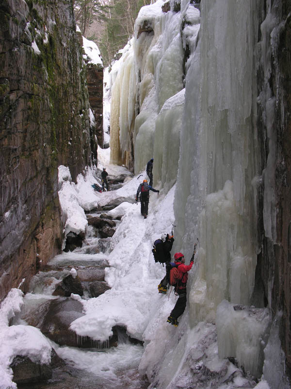
") The climbers in that picture are actually climbing sideways across the ice to get to a safe place to climb the ice columns. Note the running water below them. Extreme caution should be employed if venturing up through this section as the ice is undercut by the flowing water. If there are climbers it would probably be best to avoid attempting this as there may be falling ice as well. Good views into the gorge can be had from the platforms above and below this section.
The climbers in that picture are actually climbing sideways across the ice to get to a safe place to climb the ice columns. Note the running water below them. Extreme caution should be employed if venturing up through this section as the ice is undercut by the flowing water. If there are climbers it would probably be best to avoid attempting this as there may be falling ice as well. Good views into the gorge can be had from the platforms above and below this section.