
Amicus
Well-known member
- Joined
- Aug 28, 2005
- Messages
- 1,145
- Reaction score
- 112
Crotched Mtn. from the North - Ski Trails Living and Lost (8/14/10)
File under: Stupid Little Adventures
In the '70s, southern New Hampshire's Crotched Mtn. Ski Area occupied the NE slope of that Mtn., with a double chair nearly reaching the true summit (x2066). The NW slope hosted Bobcat, a less ambitious ski area with runs that topped out about 75% of the way up the NW ridge. By '80, Bobcat was for sale and the Crotched owners snapped it up, cutting two cross-area link trails to make a single bigger Crotched, but with the original area designated "Crotched East" and Bobcat "Crotched West."
In '88, in a fit of hubris, the Crotched owners decided to build 100 slope-area condos, and a year later the area went bankrupt. That consigned Crotched to the interesting dustbin of Lost Ski Areas, until 2003, when a new outfit bought, refurbished and reopened Crotched West only (old Bobcat) as "Crotched Mtn.," which continues to operate. The original Crotched seems likely to remain Lost. (NELSAP provided me most of the foregoing info.)
A swarm of hiking trails reach the summit from the SW, S and SE, but I wanted to try a northern approach. For one thing, I like hiking downhill ski trails, whether Living or Lost. The Living offer good footing, lots of sun and great views, with never a PUD. The Lost offer the romance of times gone by, especially if you love skiing. So, I parked in the base lodge lot for Crotched Mtn. Ski and Ride, where nothing was happening except the mowing of some of the slopes by some workers in what looked like a snow-cat, and headed up.
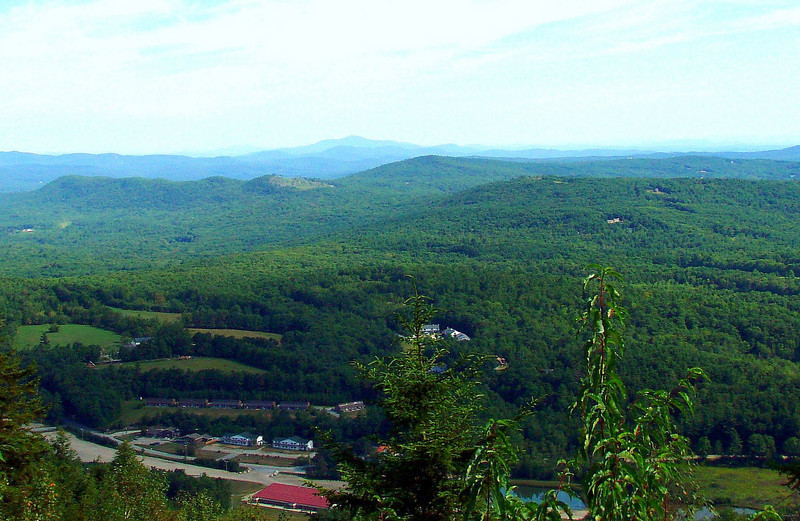
The Ski and Ride Trail map claims "Top Elevation - 2,066 Feet," but that is the elevation of the summit, roughly a half-mile to the south of the Ski and Ride's summit chair, which is at about 1,850 feet and offers fine views from W to E, with the north view centering on Kearsarge:
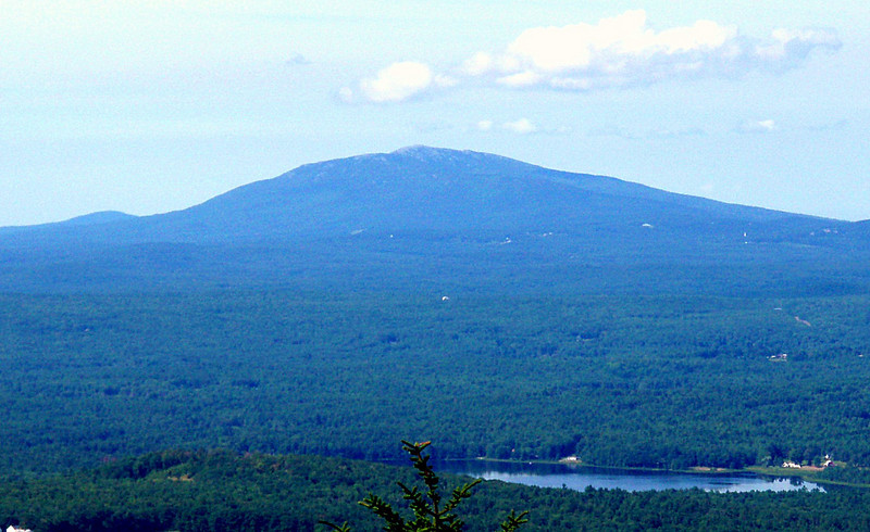
I had heard nothing about any trail from there to the summit, and Google Earth led me to assume that I might be bushwhacking that stretch. Instead, I found that a dirt road winds up from the west end of summit chair clearing, to a spot 100 vertical feet above the summit chair. At that point, a regular trail, blazed with orange paint, heads south to the summit, where Shannon's Trail joins it from the south. I took Shannon's Trail to the vista ledge I'd read about, 50 vertical feet below the summit, which gives a terrific view of Monadnock to the SW:
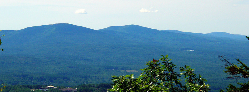
and North Pack, Pack Monadnock and the rest of the "Wapack Range" to the SE:
Returning to the summit, I found a rickety set of staircases on the north side of the fenced-in utility tower, which led me down to the clearing for the old Crotched East summit double chair, of which nothing remains except the concrete foundations. At least a dozen red-tailed hawks circled above me.
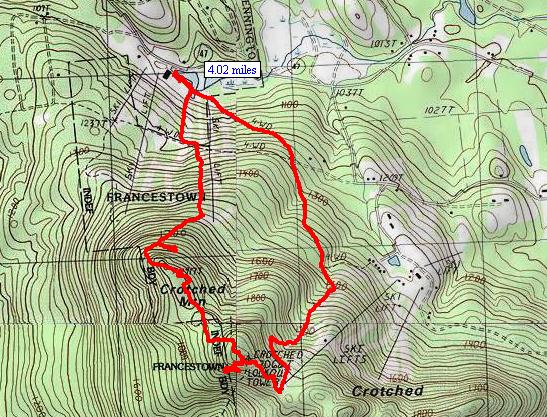
I was happy to discover that many of the old Crotched East trails are being maintained, I would guess for XC skiing, apparently by the condo association. (I passed a couple of their signs, prohibiting motorized vehicles.) I believe my route included sections of the old Sonny's Schuss, Willett's Run and Percy's Pass trails. I was particularly happy to discover that Percy's Pass was reasonably clear, as that was the linking trail that took me back to "Crotched West," exiting near the bottom of what is now the Big Dipper Trail and eliminating the road-walk I had expected. Here is my GPS track for this excellent 4-mile loop:
On to Sunapee
Since Crotched went more quickly than I had anticipated, I drove north to the Mount Sunapee ski area, which was packed, to my surprise. The League of N.H. Craftsmen was holding a huge fair and the crowds had turned out. I would have had to pay $10 to get into the fair but the parking and hiking were free. I had climbed to the summit from the south a few years ago, by the Andrew Brook and Lake Solitude Trails, but in keeping with the spirit of my day, I intended to ascend from the north by the ski trails.
Carelessly, I ascended one of the bunny trails on the west edge of the ski area, which dead-end 1,100 feet below the summit. By good luck, however, I followed a path into the woods from the top that quickly brought me to the Sunapee-Ragged-Kearsarge Greenway, which proved to be a very attractive trail to the west of the ski area, winding through a forest of mature spruce before reaching the summit plateau, 50 yards north of the big ski area building. I got my great views at the summit and on the way down, by those ski trails, including the NE view over Lake Sunapee:
This is a great southern NH parlay for hikers who like ski trails. The rest of my pix are here.
File under: Stupid Little Adventures
In the '70s, southern New Hampshire's Crotched Mtn. Ski Area occupied the NE slope of that Mtn., with a double chair nearly reaching the true summit (x2066). The NW slope hosted Bobcat, a less ambitious ski area with runs that topped out about 75% of the way up the NW ridge. By '80, Bobcat was for sale and the Crotched owners snapped it up, cutting two cross-area link trails to make a single bigger Crotched, but with the original area designated "Crotched East" and Bobcat "Crotched West."
In '88, in a fit of hubris, the Crotched owners decided to build 100 slope-area condos, and a year later the area went bankrupt. That consigned Crotched to the interesting dustbin of Lost Ski Areas, until 2003, when a new outfit bought, refurbished and reopened Crotched West only (old Bobcat) as "Crotched Mtn.," which continues to operate. The original Crotched seems likely to remain Lost. (NELSAP provided me most of the foregoing info.)
A swarm of hiking trails reach the summit from the SW, S and SE, but I wanted to try a northern approach. For one thing, I like hiking downhill ski trails, whether Living or Lost. The Living offer good footing, lots of sun and great views, with never a PUD. The Lost offer the romance of times gone by, especially if you love skiing. So, I parked in the base lodge lot for Crotched Mtn. Ski and Ride, where nothing was happening except the mowing of some of the slopes by some workers in what looked like a snow-cat, and headed up.
The Ski and Ride Trail map claims "Top Elevation - 2,066 Feet," but that is the elevation of the summit, roughly a half-mile to the south of the Ski and Ride's summit chair, which is at about 1,850 feet and offers fine views from W to E, with the north view centering on Kearsarge:
I had heard nothing about any trail from there to the summit, and Google Earth led me to assume that I might be bushwhacking that stretch. Instead, I found that a dirt road winds up from the west end of summit chair clearing, to a spot 100 vertical feet above the summit chair. At that point, a regular trail, blazed with orange paint, heads south to the summit, where Shannon's Trail joins it from the south. I took Shannon's Trail to the vista ledge I'd read about, 50 vertical feet below the summit, which gives a terrific view of Monadnock to the SW:
and North Pack, Pack Monadnock and the rest of the "Wapack Range" to the SE:
Returning to the summit, I found a rickety set of staircases on the north side of the fenced-in utility tower, which led me down to the clearing for the old Crotched East summit double chair, of which nothing remains except the concrete foundations. At least a dozen red-tailed hawks circled above me.
I was happy to discover that many of the old Crotched East trails are being maintained, I would guess for XC skiing, apparently by the condo association. (I passed a couple of their signs, prohibiting motorized vehicles.) I believe my route included sections of the old Sonny's Schuss, Willett's Run and Percy's Pass trails. I was particularly happy to discover that Percy's Pass was reasonably clear, as that was the linking trail that took me back to "Crotched West," exiting near the bottom of what is now the Big Dipper Trail and eliminating the road-walk I had expected. Here is my GPS track for this excellent 4-mile loop:
On to Sunapee
Since Crotched went more quickly than I had anticipated, I drove north to the Mount Sunapee ski area, which was packed, to my surprise. The League of N.H. Craftsmen was holding a huge fair and the crowds had turned out. I would have had to pay $10 to get into the fair but the parking and hiking were free. I had climbed to the summit from the south a few years ago, by the Andrew Brook and Lake Solitude Trails, but in keeping with the spirit of my day, I intended to ascend from the north by the ski trails.
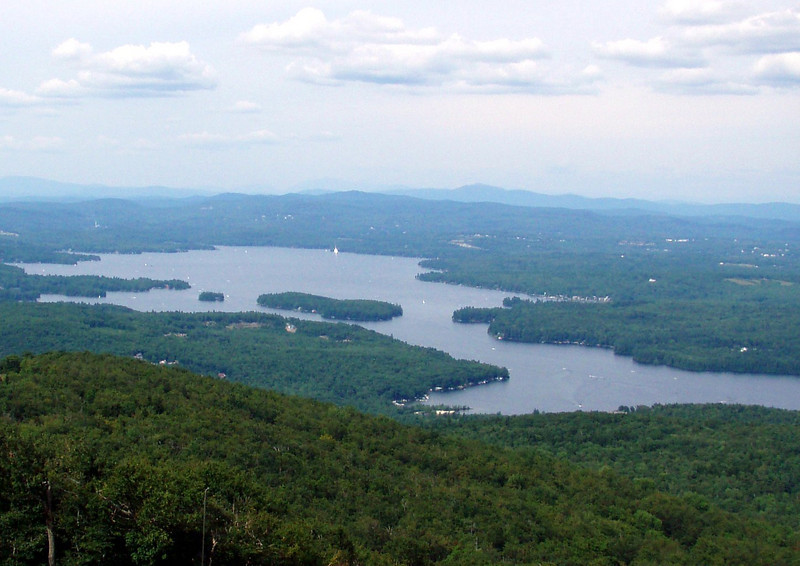
Carelessly, I ascended one of the bunny trails on the west edge of the ski area, which dead-end 1,100 feet below the summit. By good luck, however, I followed a path into the woods from the top that quickly brought me to the Sunapee-Ragged-Kearsarge Greenway, which proved to be a very attractive trail to the west of the ski area, winding through a forest of mature spruce before reaching the summit plateau, 50 yards north of the big ski area building. I got my great views at the summit and on the way down, by those ski trails, including the NE view over Lake Sunapee:
This is a great southern NH parlay for hikers who like ski trails. The rest of my pix are here.
Last edited:
") A GPS track adds a lot to a TR. Saves a lot of tedious descriptive writing left turns, right turns, etc etc
A GPS track adds a lot to a TR. Saves a lot of tedious descriptive writing left turns, right turns, etc etc