Map and compass tutorial

vftt.org

Help Support vftt.org:

This site may earn a commission from merchant affiliate links, including eBay, Amazon, and others.

hikerbrian

Active member
Joined
Apr 20, 2005
Messages
754
Reaction score
36
Location
Sharon, MA
Hi folks,

For years I've been touting the importance of map and compass skills as a critical life-preserving tool for navigating in the back country. Yet I recognize that many (most) folks don't possess even a basic understanding of how to use these two items together. To overcome the lack of knowledge, a friend and I started working on a short video over the summer that provides a tutorial on how to use these two items effectively. We're now looking for feedback. We're trying to keep the video short (less than 5 minutes) and sweet. The videos available on Youtube are generally long and wandering, but we want to work within most peoples' attention spans. The audio is really inconsistent (we've added content multiple times), and the ah, talent - if you can call it that - is severely lacking, but we'll fix all that once we're happy with content. Comments from seasoned M&C experts as well as those learning for the first time are enthusiastically welcomed. Remember, we want to keep it short, with critical points only. Video is here. THANKS!
 
Not bad for a very basic introductory first step. Good video quality. I've been teaching M&C for more than 25 years at the amateur and professional level. I'll send you a PM soon with more comments.

Keep 'em coming.
 
Last edited:
hikerbrian,

As I'm sure you will be inundated with feedback to improve your presentation, I just wish to offer kudos for what you have done here. Having been instructing this stuff for going on twenty years, I would say you've come upon a tremendously creative solution in attempting to communicate with those interested but at the new learning level - minimum time consumption through compact narrative and effective graphic format.

Long, drawn out explanations ('wandering' as you call it, how ironic eh?) on the hows and whys of M&C are a thing of the past. You have superbly adapted to the communication needs of the times.

May your initiative get others (who are so knowledgeable and capable) off their rear ends to spread the M&C gospel!
 
it really comes down to field practice - lots of it, becoming comfortable with the processes and correct navigation procedures, allowing yourself to make mistakes in a non-critical environment, learning from those mistakes, never to be made again.
 
Last edited:
A couple of years ago four of us old guys obtained a permit to backpack the "Long Range Traverse" in Newfoundland. At the Gros Morne park headquarters our group and another took the mandatory map and compass test, and even we thought our skills were adequate, I was the only one to pass the test. We were allowed to go based upon that. We also carried a Garmin MAP 60 csx, and since there are virtually no human trails on the ground up there in the Gros Morne Wilderness its use was not really of any value since due the the terrain, straight routes were generally impossible to to maintain. Every time I hear "map and compass" I think about just how difficult that process really can be.

During my 20 years as a ground pounder I never imagined how useful those interminable map and compass classes would be after so many years. I retired from Uncle Sam's Army in 1978.
 
Those are pretty good instructions.

Uncle Sam taught me how to use a map and compass and its a skill I havent forgotten. I have the pleasure of teaching my gf what I know and shes getting pretty good at recognizing terrain features, and translating it to what she sees on a map or vice versa. Of course that doesnt work so well in whiteouts, or at night, but we avoid hiking in those conditions whenever possible. Its easier staying found than try to find yourself after you are lost.
 
Its easier staying found than try to find yourself after you are lost.
Two things I tell my students all the time:

1) "You have to know where you are before you can determine where you are" - meaning you need to at least have a knowledge of your starting location, as well as keeping continuous knowledge of where you are as you travel before you can pinpoint your location.

2) "Change is the navigator's friend." - meaning change in landscape and terrain - seek out and recognize any change in terrain and match it to the map as you travel . Even a subtle change can reveal your location - pay attention.

Good going with your GF.
 
Last edited:
My observation over the years is solo practice is the quickest way to establish competency. A group effort is fine to get the basics down, but its way too easy for one person to end up in the lead.

The local "little" mountain near me, Pine Mountain, is a great practice location as it has varied terrain and has pretty good boundaries but is large enough area to make navigation interesting. With snow on the ground the going is good as its mostly hardwoods except for the summit. Its within walking distance of my house and I have spend several winter days over the years roaming around the slopes shooting bearings and following terrain features solo.
 
Thank you all for this feedback. I really appreciate it. The video has taken considerably longer to produce than I initially envisioned; but it's something I've wanted to put together for a long time.

HH1 and others, you got it exactly right wrt what I'm trying to accomplish - a short intro that shows people what is possible, hopefully gets them interested, and actually stands alone as a tutorial for what I consider to be the most important aspect of M&C navigation: going from map to compass to guide your direction of travel.

Nessmuk, I got your PM and took a good look at your write up. It is outstanding, and it's what I hope folks will seek out once they get a taste of what is possible with my video. The niche I'm trying to fill is in the <5 min attention span of most casual hikers. It doesn't take long to get the basics down. Though you're absolutely right: practice is critical.

In the next iteration, I hope to have links embedded in the video for 1) a longer (2 min) explanation of declination; 2) a 2 min video showing the process of choosing the correct direction at a trail junction; and 3) a 2 min video of choosing the correct way down from the top of a peak. I also hope to add links to longer discussions of M&C, including triangulation to determine location. But I think if I added all of these to the intro video, it would be 15 min and no one would make it past the first minute.

I remember the feeling when I first learned how to use a compass with a map. It felt like magic. "Wait, I can tell even with zero visibility that Peak X is EXACTLY in that direction?! And I know for certain THIS is the right direction down from this peak?! And I can use my compass to identify ALL of the peaks I can see on the horizon?!!! HOLY S***BALLS, this is AMAZING!!" I'd like to convey that magic to just a couple of other people.
 
There's no greater joy for an instructor in the field than to see a little bit of struggle in a student, then suddenly, "hey, this stuff really works", as the light bulb comes on.

Just wait until you get to the part where you explain and exercise measurement of UTM coordinates.
 
Last edited:
Concise and to the point - great job on this! I guess I would probably say that most or great majority of maps have North at the top but I would shy away from implying that it is always the case.
 
Hi folks,

Comments from seasoned M&C experts as well as those learning for the first time are enthusiastically welcomed. Remember, we want to keep it short, with critical points only. Video is here. THANKS!

Since you asked for tips to pass along to beginners, you may want to add the effect of close-by metallic items like belt buckles, hiking poles etc. and also explain the 50 foot rule.
 
watched the video yesterday and enjoyed it. Thanks. It's nice to see White Mountain location as part of the video (Franconia Ridge). :)

I've been part of a few orienteering events throughout my life, mostly in my early years to know how to use a map and compass but I feel subconscious when the subject pops up in on a trip in the field. I just don't use map and compass at all anymore to keep the skill up to date. For the record, I don't use GPS either. In my entire life I lost a trail less than 5 times (I can only remember losing it twice but I'm adding 3 more for a good measure) and when that happened it was remedied within 15 - 30 minutes. I do use maps all the time to plan and to verify where I am during my trip but the compass never comes out of the bag.


What I'm trying to say is that I keep telling myself to practice some fun orienteering every season but I rarely do. I would love to join a fun, non competitive event or organize a course for my backpacking friends. In the process I would refresh my skills. My only hesitation is that I don't want to join clubs and be pressured to attend regular events.
 
Last edited:
Nice job HikerBrian. I think your video will be very helpful. I'm no expert but I have spent a lot of time being lost in the woods and getting unlost.

@1:49, perhaps you should identify the "red arrow on the dial"?

Two things you said in the video confused me a little. Perhaps easily corrected with an explanation and animation overlay. In the review section:

@ 4:16 "Be sure the direction of travel arrow is pointed towards your destination" (perhaps add "you are traveling in this direction" with reinforce the direction of travel with an animated line)

@ 4:28 "Be sure the red arrow on the dial is pointed north ..." (perhaps add why this is matters or what would happen is south at the top)


As a refresher for an orienteering race a few weeks ago (first O race in a few years) I read this short 4 page tutorial. It's old and dated but the information is clear and very helpful. I especially liked the vocabulary he used and found it easy to follow along and remember. http://www.learn-orienteering.org/old/lesson1.html. Perhaps you could leverage some of that vocabulary?

Either way, Nice work!
 
Last edited:
I just don't use map and compass at all anymore to keep the skill up to date. For the record, I don't use GPS either.
You don't always need a compass to have directional cognition for travel in the woods. With knowledge of landscape and other natural clues there most often is plenty navigation directional information available without using a magnetic compass. I can't tell you how many times when, at the beginning of one of my classes, I ask for students' prior experience with M&C. Usually I hear something like: "I learned it a while ago, but I'm a little rusty now". Then when they pick up a compass they don't recall the first thing about using it much less put it to a map. I've had students want to walk in the direction of the red arrow regardless of where they really want to go.

I learned to hike the woods from my dad a very long time ago. He always seemed to know where he was going, being familiar with the territory, only rarely referring to a small lapel compass. Later I got a lot more serious about finding my way much more precisely with M&C. Back in the day when the Air Force actually trained and used aircraft flight navigators, that's how I was employed for several years, navigating anywhere worldwide. The concepts and mindset are much the same, in air or on land. Recreationally hiking, my wilderness destination goals are rarely 100% along marked trails. I took it upon myself to become an expert land navigator, and have been teaching wilderness guides and SAR teams for many years now.

In my entire life I lost a trail less than 5 times (I can only remember losing it twice but I'm adding 3 more for a good measure) and when that happened it was remedied within 15 - 30 minutes. I do use maps all the time to plan and to verify where I am during my trip but the compass never comes out of the bag.
The sad thing about (usually older men, often aging hunters) folks who are positive that they know certain terrain, often going to those the same places their entire lives, is those are the guys who we end up as subjects of my SAR team. A significant percentage of SAR incidents these days are just that. Not much you can do about the aging process and creeping mental confusion other than to keep exercising, keep practicing the skills, and being always open to learning.
 
Very nice! Clear, concise, and annotated with helpful graphics.

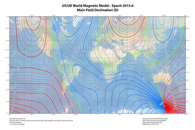
BTW, your target audience for this video is tacitly "eastern North Americans". Perhaps it should be overt because a large segment of the earth's population will be led astray if they add the declination adjustment.

 
Very nice! Clear, concise, and annotated with helpful graphics.

BTW, your target audience for this video is tacitly "eastern North Americans". Perhaps it should be overt because a large segment of the earth's population will be led astray if they add the declination adjustment.

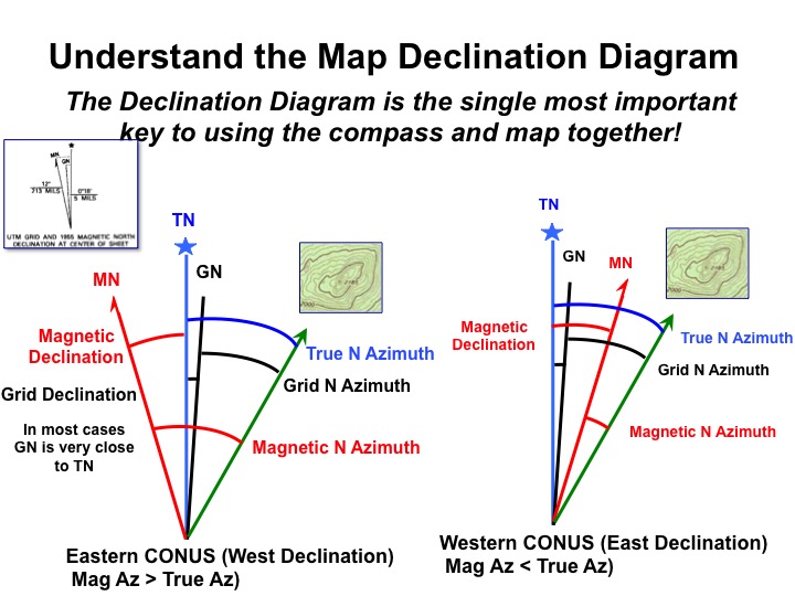
Here's how I present the Declination problem (when do you add, when do you subtract?) It sounds more complicated than it really is.

If going from map (true north reference) measurement to compass (magnetic north reference) measurement
1. Given an azimuth relative to True North (as would be measured by a protractor directly from the map)
2. Look at the declination diagram for your region (draw one if it is not apparent)
3. Imagine an object of interest and its azimuth in the first quadrant (makes no difference where the object actually is relative to you)
4. Ask yourself:From the diagram, is the magnetic azimuth angle to the object greater or smaller than the true azimuth angle to the object?
5. If the mag azimuth angle is greater, then you will add the declination to the given True N azimuth angle (if smaller then subtract)- this is what you set your compass to, then turn your body to "box the needle" to walk to the field destination.

If going from compass azimuth(magnetic north reference) measurement to map azimuth (true north reference) measurement
1. Given the magnetic azimuth of an observed object relative to Magnetic North (as would be measured in the field directly with a magnetic compass)
2. Look at the declination diagram for your region (draw one if it is not apparent)
3. Imagine an object of interest and its azimuth in the first quadrant (makes no difference where the object actually is relative to you)
4. Ask yourself: From the diagram, is the true azimuth angle to the object greater or smaller than the magnetic azimuth angle to the object?
5. If the true azimuth angle is smaller, then you will subtract the declination from the magnetic azimuth angle (if larger then add) - turn the bezel of your compass to this angle to use it as a true north protractor on the map.

(In most cases the Grid north lines pre-drawn on topo maps are usually within 2 degrees of TN, practically accurate enough for most to use as true TN reference - or you can manually mathematically adjust for Grid Dec in a similar manner)

Simplified: From the dec diagram: "Which angle is larger?" add or subtract appropriately.


Alternatively, you can draw magnetic north lines directly on the map as reference lines and never have to worry about adding or subtracting declination again.


KFaVtk6.jpg
 
Last edited:
The trick is to distill that into an easily digestible, and memorable, format that fits into Brian's planned 2-minute video!


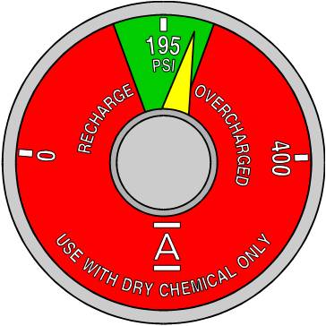
My own "memory trick" lies in how I interpret the little declination diagram. Think of it like an analog gauge (like on a fire extinguisher). The compass doesn't agree with the map (it can't speak "map"). The gauge tells you by how much (under or over).

PFE%20Gauge.jpg


  1. The True North line represents the "optimal" value. It's even has a little star that says so! :)
  2. The Magnetic North Arrow is like the gauge's needle. It shows how far off things are from "optimal".
  3. If the Mag arrow is on the left, it falls short of optimal. Compensate for this shortfall by adding declination (+).
  4. If Mag arrow is on the right, it exceeds optimal. Compensate for this excess by subtracting declination (-).

Naturally, this works exclusively for converting map to compass bearings. Map -> Compass. Real -> Imaginary.
If you want to go in the reverse direction, Compass -> Map, Imaginary -> Real, then you have to "reverse" the compensations. #3 becomes subtraction and #4 becomes addition.


Or you can buy a compass with declination adjustment, set it properly, and fuhgeddaboudit.
 
Last edited:
Or you can buy a compass with declination adjustment, set it properly, and fuhgeddaboudit.

^^^ This. ^^^

Just remember to reset it appropriately when you travel to an area with a different declination.
 
Top