It has been a while since I've written a trip report, mainly because it's been a while since I've done anything really new or unique, aside from bringing my dog. Over a year ago, I agreed to do the Arrow Slide some day with Whitney. Now that she has returned from her AT thru hike, we both had the time to do this hike. I wanted to include Northwest Hancock for the TW72 list, and Chris wanted to do the Cedar Brook Slide. This particular hike met the needs (wants) of all three of us and was a good opportunity to take bushwhacking up a level.
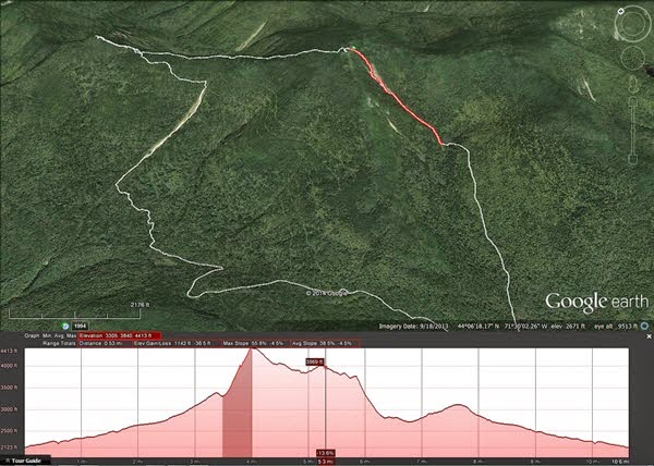
Entire Route (excluding the regular trails to the Hancock Loop)
We started out via Hancock Notch to Cedar Brook to Hancock Loop to the dry stream bed on the left branch (North Hancock branch). From there, we easily found the run-out of the Arrow Slide. The first half is over mostly stable boulders in a narrow channel. Ascending required thought and caution to not drop rocks on the person below you, but wasn't difficult nor did it offer any options. At the base of the arrow portion, there comes your first choice - stay to the left to avoid the wet and slimy ledge - even as bone dry as the usually wet trails were, the slide still had some minimal water running down it.
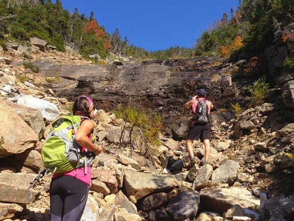
Wet Ledge Obstacle - go left
At this obstacle, we went left around it and along the left edge for a bit, before returning to the middle. At the next obstacle, we went left, but had to backtrack when it got too steep and slippery, and we went around it to the right this time. Above this, the going was easier to the left, and from there, we crossed to the right / higher side of the obvious split right below the top. We chose not to put on long sleeve and pants which probably was a bad decision. It was very hot, but the thickest sustained bit of dead spruce awaited us on the push to the trail. We stopped at the lookout for a while, looking a bit ragged to the other visitors. Putting on long sleeves and pants probably made us seem even stranger.
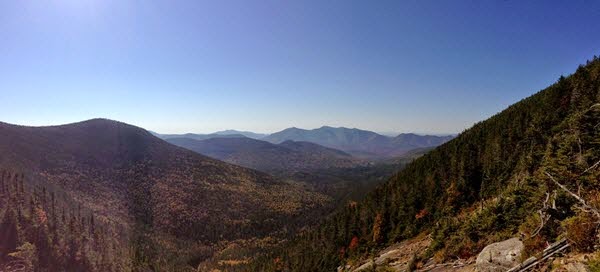
View of The Osceolas From Atop Arrow Slide
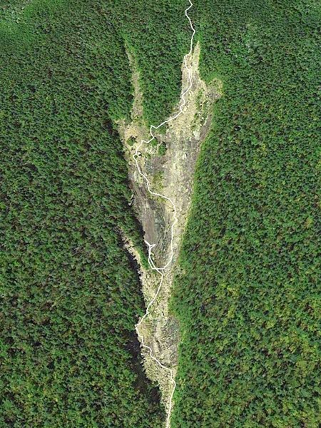
Route Up Arrow Slide
From the summit of North Hancock, we headed toward South Hancock, and after a couple dozen steps, turned left on a pretty obvious herd path. This path goes down and below the viewpoint and basically ends. From here, we set a bearing of 345M while trying to stay as close to the ridge as possible. The descent off North Hancock is not very ridge like, so the bearing was important, but once on the ridge, it's pretty easy to follow the top. The woods alternate between beautiful open stretches and short thick sections. Along the way, there are glimpses of Northwest Hancock to confirm one is still on the bearing. The summit cone is pretty obvious - put the compass away and head up. There is a false summit just before the real one, which has a view into the ravine that feeds Crystal Brook. There is a very steep and impressive slide across the ravine.
On the return trip from Northwest Hancock, we cheated to the west/southwest side in hopes of catching sight of the exit route - Cedar Brook Slide. This also served a dual purpose of finding and following two of the old haul roads that are so obvious from Bondcliff and on Google Earth. Upon reaching one of them, Chris and I looked at each other and immediately noted what we had found. We followed one at 3760 feet or so to the top of the slide. We sat here and and had a snack and planned our descent - spaced 20 feet apart across the width of the slide.
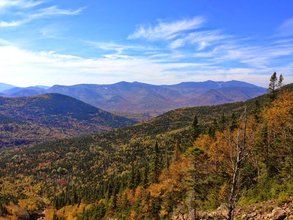
View Towards Franconia Ridge from Cedar Brook Slide
After a short, narrow section, the slide widens up and has a fantastic view from the Hitchcocks to Owl's Head and Whaleback through Franconia Ridge. This slide is mostly loose sand and rock - with a few big boulders. Extra caution is warranted here as it we moved several boulders rather easily - ones we wouldn't be able to move without a gravity and rubble assist. We took turns descending the two outer edges and down the trough in the middle. The edges are flatter with more rock, and the middle is all loose sand, pebbles, and rocks.
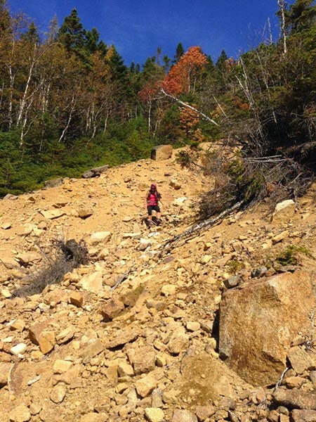
Descending a "Rocky Beach" Stretch
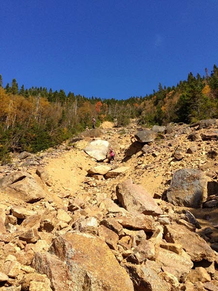
Trough-Like Descent
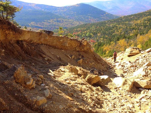
Nearing the Run Out
Nearing the bottom, a spring entered the slide and we had to content with some wet and slippery rocks, and shortly thereafter, blowdowns and other obstacles. It was time to bushwhack through the woods to find the Cedar Brook Trail. I took a bearing to hit it below the switchback and adjusted course to avoid most of the thick sections. We ended up in a boggy section with lots of moose poop and prints, and skirting that towards the direction of Cedar Brook meant walking through some thick spruce with a maze of blowsdowns. We came out at a nice campsite a few paces from the trail, where we dumped the long sleeves and pants and hiked back out via Cedar Brook Trail and the usual exit.
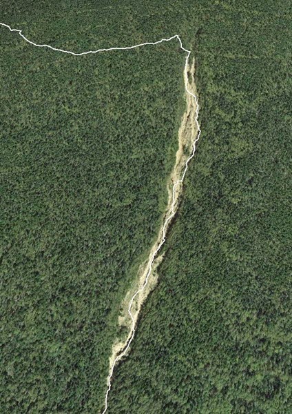
Route Down Cedar Brook Slide
Tim

Entire Route (excluding the regular trails to the Hancock Loop)
We started out via Hancock Notch to Cedar Brook to Hancock Loop to the dry stream bed on the left branch (North Hancock branch). From there, we easily found the run-out of the Arrow Slide. The first half is over mostly stable boulders in a narrow channel. Ascending required thought and caution to not drop rocks on the person below you, but wasn't difficult nor did it offer any options. At the base of the arrow portion, there comes your first choice - stay to the left to avoid the wet and slimy ledge - even as bone dry as the usually wet trails were, the slide still had some minimal water running down it.

Wet Ledge Obstacle - go left
At this obstacle, we went left around it and along the left edge for a bit, before returning to the middle. At the next obstacle, we went left, but had to backtrack when it got too steep and slippery, and we went around it to the right this time. Above this, the going was easier to the left, and from there, we crossed to the right / higher side of the obvious split right below the top. We chose not to put on long sleeve and pants which probably was a bad decision. It was very hot, but the thickest sustained bit of dead spruce awaited us on the push to the trail. We stopped at the lookout for a while, looking a bit ragged to the other visitors. Putting on long sleeves and pants probably made us seem even stranger.

View of The Osceolas From Atop Arrow Slide

Route Up Arrow Slide
From the summit of North Hancock, we headed toward South Hancock, and after a couple dozen steps, turned left on a pretty obvious herd path. This path goes down and below the viewpoint and basically ends. From here, we set a bearing of 345M while trying to stay as close to the ridge as possible. The descent off North Hancock is not very ridge like, so the bearing was important, but once on the ridge, it's pretty easy to follow the top. The woods alternate between beautiful open stretches and short thick sections. Along the way, there are glimpses of Northwest Hancock to confirm one is still on the bearing. The summit cone is pretty obvious - put the compass away and head up. There is a false summit just before the real one, which has a view into the ravine that feeds Crystal Brook. There is a very steep and impressive slide across the ravine.
On the return trip from Northwest Hancock, we cheated to the west/southwest side in hopes of catching sight of the exit route - Cedar Brook Slide. This also served a dual purpose of finding and following two of the old haul roads that are so obvious from Bondcliff and on Google Earth. Upon reaching one of them, Chris and I looked at each other and immediately noted what we had found. We followed one at 3760 feet or so to the top of the slide. We sat here and and had a snack and planned our descent - spaced 20 feet apart across the width of the slide.

View Towards Franconia Ridge from Cedar Brook Slide
After a short, narrow section, the slide widens up and has a fantastic view from the Hitchcocks to Owl's Head and Whaleback through Franconia Ridge. This slide is mostly loose sand and rock - with a few big boulders. Extra caution is warranted here as it we moved several boulders rather easily - ones we wouldn't be able to move without a gravity and rubble assist. We took turns descending the two outer edges and down the trough in the middle. The edges are flatter with more rock, and the middle is all loose sand, pebbles, and rocks.

Descending a "Rocky Beach" Stretch

Trough-Like Descent

Nearing the Run Out
Nearing the bottom, a spring entered the slide and we had to content with some wet and slippery rocks, and shortly thereafter, blowdowns and other obstacles. It was time to bushwhack through the woods to find the Cedar Brook Trail. I took a bearing to hit it below the switchback and adjusted course to avoid most of the thick sections. We ended up in a boggy section with lots of moose poop and prints, and skirting that towards the direction of Cedar Brook meant walking through some thick spruce with a maze of blowsdowns. We came out at a nice campsite a few paces from the trail, where we dumped the long sleeves and pants and hiked back out via Cedar Brook Trail and the usual exit.

Route Down Cedar Brook Slide
Tim
Last edited:
