Some Connecticut mountains - I love the Mt Riga area

vftt.org

Help Support vftt.org:

This site may earn a commission from merchant affiliate links, including eBay, Amazon, and others.

SpencerVT

Member
Joined
May 26, 2015
Messages
411
Reaction score
20
Location
Brattleboro, Vermont
I always really loved the Mount Washington area of Massachusetts and how the Taconics go down into the extreme northwest corner of Connecticut a little bit.
Additionally, the Mt Riga area of Connecticut has some fascinating history regarding the high elevation Iron Ore mining and settlement. If you ever get a chance to check out the very old cemetery high up off the Mt Riga road, it is quite an awesome New England place. I've been trying to climb all the peaks in those areas. Don't be fooled - some of these can pack a punch because the Mountain Laurel is a Venus flytrap for hikers which will tangle and ensnare even the best contortionists amongst us.

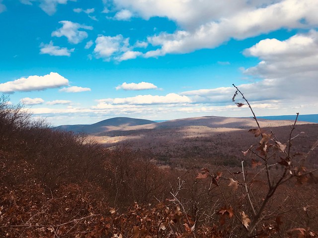
My wife and I bushwhacked Mount Ashley near the border of CT in Mass. A hard and steep bushwhack because of the mutant science fiction Mountain Laurel. The summit had tremendous and rewarding views:
44249355890_fbbe35223e_z.jpg

Afterwards, we climbed Mt Plantain, which was also lots of fun and we found a herd trail to the summit.

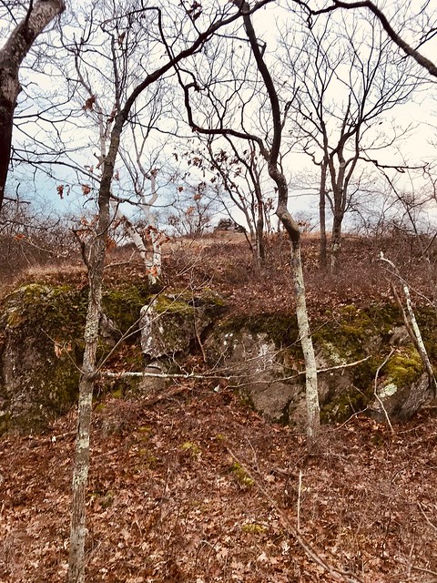
I also went down on a different day and climbed Lions Head and Bird Mountain. I approached Bird Mountain from the Lakeville Reservoir which was the same way I approached Thorpe Mountain last year. An easy bushwhack with minimal Mountain Laurel. As you can see there is an enormous cairn atop Bird Mountain, with great views in multiple directions. A fantastic peak.
44249354840_b259384fa4_z.jpg

44249355050_a56759e9e9_z.jpg
 
That whole area is loaded with Mountain Laurel. In the early summer, it blankets those mountains in white and pink, and is really quite astounding.
 
I love backpacking this area when it is monorail season in the North.

Have you seen the thread here on doing a loop of the AT and Taconic?

Did you need permission to visit that cemetary? I have been under the impression that most of the Mt Riga area was private property.
 
To the best of my knowledge, you do not need permission to visit the cemetery, you can drive up right to it. A lot of the mount Riga area is private, but there appears to be plenty of open land as well.
I will have to check out that loop thread!
 
Here's a hike in that general area I used to like; haven't done it in 7 years so who knows. I've heard the light-blue trail may have had its blazes obscured because the slope was too steep (it isn't).

Route from West Street (near Mt Ethel) to the Bash Bish Falls Parking Lot

A great walk idea mostly because of the wonderful views at the end, west beyond Cedar Mt. and the old Northrup Trail.

There is day parking nearby at the at the pond on West Streets just NE of Mt Ethel. There are parking spots at a State Library building even closer to the start of the walk, but no indication one way or the other if parking is permitted.

The route consists of these paths, in order: 1. the Northrup Trail, 2. the Pink Trail , 3. a very short mostly easy unblazed bushwhack connecting the Pink to the LiteBlue Trail, and 4. the Parking Lot Trail.

There are two minor (1/4 mile or less) gaps in the paths; I'll describe them in the following narrative.

The old un-blazed Northrup Trail starts out just like on the old maps, at 42°07'16.7", -73°28'33.4" on West Street, just opposite a metal gate abutted by wood fencing in both directions, and heads west. After about 3/4 of a mile of woods road walking it comes to a problem area at a knoll/foothill of Mt. Ethel. Lots of blowdowns or maybe logging in this messy area. Incidentally, around a hundred yards before this first knoll, a woods road branches off to the left (S) and down to a trickling stream and literally acres of fairly flat non-sanctioned sleeping opportunities. Should that first stream be dry or too meager to draw water from, there is a more robust stream further on (you'll hear it).

I just follow other un-blazed and un-named paths/game trails straight up and over the knoll and onward W/very slightly SW. There are other paths around more to the left (S), but some extensive scrub patches to deal with. I think the Northrup itself probably circles around to the right (N/NW) but I have not looked. I just take a heading to pick up the Pink Trail (blazed with pink tape; sometimes it's actually the Northrup, sometimes parallel to it) at around 42°07'11.8", -73°29'9.6" in about 1/4 mile, using the path traces and game trails, zigzagging to avoid scrub as required (very little). The natural flow of walking seems to pick up the Pink Trail just a little further on and a tiny bit uphill. [to be continued]
 
[continued from part 1]
Here you have a choice. The Northrup tends to stay up on the ridge to the right (N), while the pink-tape blazed trail parallels it slightly downslope to the its left (S). I'm more comfortable just following the Pink Trail west. It's more scenic because you can sometimes see through the trees to the South whereas the ridge top is too thickly wooded-in. Note that the pink tape is often 10-30 feet to the left or right of the actual path it's marking. I have no idea why. Maybe a Winter plot? Generally the woods are so open here you can just stay on a compass heading West and wander as you please. There are many path traces running E-W, though they fade in and out. If you stray too far downhill from the Pink, it's sometimes easy but sometimes gets thick.

The Pink has a brief problem near the broad central north Cedar peak area (just slightly NE of the actual Cedar high point . A mess; lots of scrub. But since this area is wooded and unremarkable anyway, I usually skip it, abandoning the Pink temporarily at 42°07'16.3", -73°29'33.6", and stay W/SW rather than continuing slightly north. An easy bushwhack of a few hundred yards through open woods picks up the Pink Trail again W/SW of Cedar at 42°07'15.5", -73°29'45.5". Actually I think much of this easy bushwhack is so easy because we're back on the old Northrup again. I'm also pretty sure I've detected the Northrup here heading down S from the Cedar Cedar high point, but it's badly infringed by scrub from the sides, punishing stiff branches. I've never followed it far; too many good alternatives.

If you really want to visit the north central Cedar peak(s), it's easy enough, continuing on the Pink, using the Northrup when you can find it, and trace paths which I think are game trails here, but you have scrub patches to work around that are more extensive than earlier in the walk. If you do these peaks, ignore the last couple of pink tapes descending the northernmost central peak to the NW, they go nowhere any good; instead keep left SW-ish and rejoin the Pink at the before-mentioned 42°07'15.5", -73°29'45.5". Incidentally there is frequently standing water (deep and pretty clear) about halfway (at 42°07'19.1", -73°29'41.0") between the northernmost Cedar peak and where the tape picks up, and there are several flat sleeping spots in this general area.

Whether you hit the Cedar peaks or skipped them, we are now west beyond Cedar and the Northrup, but nearing the best part of the walk.

Soon, at 42°07'16.6", -73°29'56.5", the Pink starts swinging to the N/NE (All the way to Cedar Creek? I have no idea. That would be great and I'm going to try setting off in that direction some day to check it out). Instead, abandon the Pink and head S. Almost immediately, at 42°07'16.0", -73°29'57.0", you have your first real bushwhacking, a barrier of really thick scrub. I mean rip off your hat, eyeglasses, and anything attached to your pack thick. But it's only 10-15 yards and WORTH it. You break out into a series of viewpoints among my favorites anywhere. Fine in Summer, GREAT just after leaf peak, when enough of the leaves have fallen off the downslope trees to fully open it up but you still see intense color for miles in an almost 180 degree arc. In winter, it's beyond description! [to be continued]
 
[continued from part 2]
Descend S and then SE, staying on the rock outcroppings. Tiny bits of scrub in between. The views are even better lower down because of the perspective and because the slope becomes sparsely treed. Look to the S (between leafy branches in Summer) and you'll see the Falls! Hear them too. Just remarkable, a secret treasure protected by the thick brush the way we've come in, and a section of somewhat steep trail-less rock-strewn slope down the way we're going out. At the lowest of the dramatic views there is a single tree you'll wish you could take a chainsaw to, to make it perfect, but still amazing.

When you're done enjoying, which will take a long time, diagonal down S/SE across the Sparse Slope; a little steep, but good footing on intermittent rocks. Soon you'll start picking up the LiteBlue blazed trail beginning at 42°07'11.4", -73°29'52.4". Blazes so faded they are starting to look white. This very old but still discernible trail takes you gently all the way down to the road ( Rt. 344) a quarter of a mile or so N of the BashBish parking lot. But just before you descend the last 20-30 yards to the road, the un-blazed Parking Lot trail turns slightly uphill left, then parallels 344, and takes you right out to the lot, a much nicer ending to a very nice walk.

If I can remember how, I'll attach a gpx track here. Text dump of it in next post if it takes.


Northrup Cedar BashBish map1.jpg
 
Last edited:
Format: DMS M/D/Y H:M:S -4.00 hrs Datum[073]: NAD27 CONUS


ID
Name
Comment
Date Time
Latitude
Longitude
Icon
Display Option
Altitude

R
1
Northrop Traverse


W
Northrop01
verified good
00:00.0
42°07'16.7"
-73°28'33.4"
Waypoint
NS


W
Northrop02
verified good
00:00.0
42°07'16.0"
-73°28'35.8"
Waypoint
NS


W
Northrop03
verified good
00:00.0
42°07'15.6"
-73°28'40.3"
Waypoint
NS


W
Northrop04
verified good
00:00.0
42°07'15.1"
-73°28'45.5"
Waypoint
NS


W
Northrop05
verified good
00:00.0
42°07'14.5"
-73°28'50.3"
Waypoint
NS


W
Northrop06
verified good?
00:00.0
42°07'13.6"
-73°28'51.7"
Waypoint
NS


W
P01

00:00.0
42°07'11.8"
-73°29'09.6"
Waypoint
NS
547.1

W
P02

00:00.0
42°07'11.8"
-73°29'10.6"
Waypoint
NS
545.9

W
P03

00:00.0
42°07'12.0"
-73°29'11.5"
Waypoint
NS
546.8

W
P04
Unknown Trail Intersect Go R N
00:00.0
42°07'12.1"
-73°29'12.2"
Waypoint
NS
558.1

W
P05

00:00.0
42°07'12.3"
-73°29'12.3"
Waypoint
NS
545.6

W
P06

00:00.0
42°07'12.3"
-73°29'12.8"
Waypoint
NS
545.3

W
P07

00:00.0
42°07'12.5"
-73°29'13.8"
Waypoint
NS
544.7

W
P08

00:00.0
42°07'13.4"
-73°29'17.9"
Waypoint
NS
551.1

W
P09

00:00.0
42°07'13.6"
-73°29'18.2"
Waypoint
NS
551.7

W
P10

00:00.0
42°07'13.8"
-73°29'19.4"
Waypoint
NS
556.6

W
P11

00:00.0
42°07'13.9"
-73°29'19.9"
Waypoint
NS
557.8

W
P12

00:00.0
42°07'14.0"
-73°29'20.8"
Waypoint
NS
560.2

W
P13

00:00.0
42°07'14.0"
-73°29'21.7"
Waypoint
NS
562.4

W
P14

00:00.0
42°07'14.0"
-73°29'22.7"
Waypoint
NS
560.2

W
P15

00:00.0
42°07'14.1"
-73°29'23.3"
Waypoint
NS
560.5

W
P16

00:00.0
42°07'13.8"
-73°29'25.7"
Waypoint
NS
560.2

W
P17

00:00.0
42°07'13.6"
-73°29'26.9"
Waypoint
NS
559.9

W
P18

00:00.0
42°07'15.2"
-73°29'30.4"
Waypoint
NS
568.5

W
P19

00:00.0
42°07'15.7"
-73°29'30.8"
Waypoint
NS
572.7

W
P20

00:00.0
42°07'16.4"
-73°29'32.8"
Waypoint
NS
571.2

W
P21

00:00.0
42°07'16.3"
-73°29'33.6"
Waypoint
NS
575.8

W
Northrop15
from map
00:00.0
42°07'16.2"
-73°29'33.9"
Waypoint
NS


W
Northrop16
from map
00:00.0
42°07'15.5"
-73°29'36.8"
Waypoint
NS


W
Northrop17
from map
00:00.0
42°07'15.2"
-73°29'40.3"
Waypoint
NS


W
P28
Picks up after gap
00:00.0
42°07'15.5"
-73°29'45.5"
Waypoint
NS
556

W
P29

00:00.0
42°07'16.4"
-73°29'47.6"
Waypoint
NS
551.1

W
P30

00:00.0
42°07'16.7"
-73°29'48.7"
Waypoint
NS
547.4

W
P31

00:00.0
42°07'17.2"
-73°29'49.9"
Waypoint
NS
540.4

W
P32

00:00.0
42°07'17.4"
-73°29'50.4"
Waypoint
NS
541

W
P33

00:00.0
42°07'17.6"
-73°29'52.4"
Waypoint
NS
548.3

W
P34

00:00.0
42°07'17.7"
-73°29'52.9"
Waypoint
NS
543.8

W
P35

00:00.0
42°07'17.8"
-73°29'53.6"
Waypoint
NS
544.1

W
P36

00:00.0
42°07'17.6"
-73°29'54.2"
Waypoint
NS
542.2

W
P37

00:00.0
42°07'16.9"
-73°29'54.5"
Waypoint
NS
541

W
P38

00:00.0
42°07'16.6"
-73°29'55.1"
Waypoint
NS
540.4

W
P39

00:00.0
42°07'16.7"
-73°29'55.6"
Waypoint
NS
539.2

W
P40

00:00.0
42°07'16.7"
-73°29'56.3"
Waypoint
NS
537.1

W
P41
Leave Pink Go S Down
00:00.0
42°07'16.6"
-73°29'56.5"
Waypoint
NS
538.6

W
Breakthruscrub
Break through heavy scrub
00:00.0
42°07'16.0"
-73°29'57.0"
Waypoint
NS
533.4

W
High View
Stay on rocks SSE then S
00:00.0
42°07'15.5"
-73°29'57.5"
Waypoint
NS
530.5

W
Lower View
Can see Falls from here
00:00.0
42°07'14.9"
-73°29'57.0"
Waypoint
NS
524.5

W
View
From here,clear all way Down SE
00:00.0
42°07'14.0"
-73°29'57.2"
Waypoint
NS
520.9

W
AcrossSparSlp
Diagonal Down across the Sparse Slope
00:00.0
42°07'13.7"
-73°29'56.3"
Waypoint
NS
515.1

W
NorWP01

00:00.0
42°07'13.4"
-73°29'56.2"
Waypoint
NS
510.3

W
NorWP02

00:00.0
42°07'12.7"
-73°29'55.3"
Waypoint
NS
499

W
LiteBlue01

00:00.0
42°07'11.4"
-73°29'52.4"
Waypoint
NS
480.7

W
LiteBlue02

00:00.0
42°07'10.8"
-73°29'51.6"
Waypoint
NS
473.7

W
LiteBlue03

00:00.0
42°07'10.2"
-73°29'51.0"
Waypoint
NS
465.7

W
LiteBlue04

00:00.0
42°07'09.9"
-73°29'50.7"
Waypoint
NS
460.6

W
LiteBlue05

00:00.0
42°07'09.1"
-73°29'50.0"
Waypoint
NS
431

W
LiteBlue06

00:00.0
42°07'08.3"
-73°29'48.3"
Waypoint
NS
447.8

W
LiteBlue07

00:00.0
42°07'08.0"
-73°29'47.8"
Waypoint
NS
445.3

W
LiteBlue08Ltur
Left Turn
00:00.0
42°07'06.9"
-73°29'46.0"
Waypoint
NS
392.6

W
LiteBlue09

00:00.0
42°07'06.8"
-73°29'45.5"
Waypoint
NS
420.9

W
LiteBlue10

00:00.0
42°07'06.7"
-73°29'44.9"
Waypoint
NS
419.1

W
LiteBlue11

00:00.0
42°07'05.8"
-73°29'43.2"
Waypoint
NS
414.8

W
LiteBlue12

00:00.0
42°07'05.2"
-73°29'41.6"
Waypoint
NS
413.6

W
LiteBlue13

00:00.0
42°07'05.0"
-73°29'40.5"
Waypoint
NS
406.9

W
LiteBlue14

00:00.0
42°07'04.5"
-73°29'38.9"
Waypoint
NS
401.7

W
LiteBlue15

00:00.0
42°07'04.2"
-73°29'38.7"
Waypoint
NS
409

W
LiteBlue16

00:00.0
42°07'03.5"
-73°29'37.8"
Waypoint
NS
401.1

W
LiteBlue17

00:00.0
42°07'03.6"
-73°29'37.5"
Waypoint
NS
400.2

W
LiteBlue18

00:00.0
42°07'03.5"
-73°29'37.4"
Waypoint
NS
400.5

W
LiteBlue19

00:00.0
42°07'03.4"
-73°29'36.8"
Waypoint
NS
399.3

W
LiteBlue20

00:00.0
42°07'02.8"
-73°29'34.7"
Waypoint
NS
392

W
LiteBlue21

00:00.0
42°07'02.6"
-73°29'33.8"
Waypoint
NS
391.4

W
LiteBlue22

00:00.0
42°07'01.7"
-73°29'32.6"
Waypoint
NS
384

W
PL01

54:02.0
42°07'01.1"
-73°29'31.7"
Waypoint
NS
381.3

W
PL02

52:34.0
42°07'00.6"
-73°29'31.1"
Waypoint
NS
382.7

W
PL03

51:28.0
42°07'00.7"
-73°29'30.1"
Waypoint
NS
385.4

W
PLStream1

01:50.0
42°07'00.5"
-73°29'29.7"
Waypoint
NS
388.3

W
PL04

50:03.0
42°06'59.6"
-73°29'29.3"
Waypoint
NS
391.1

W
PL05

49:10.0
42°06'58.7"
-73°29'28.9"
Waypoint
NS
395.2

W
PLStream2

04:23.0
42°06'57.7"
-73°29'29.1"
Waypoint
NS
396.2

W
PL06

47:32.0
42°06'56.1"
-73°29'29.5"
Waypoint
NS
398.3

W
PL07

45:46.0
42°06'54.9"
-73°29'31.1"
Waypoint
NS
395
 
Top