The North Country

vftt.org

Help Support vftt.org:

This site may earn a commission from merchant affiliate links, including eBay, Amazon, and others.

askus3

New member
Joined
Sep 8, 2003
Messages
678
Reaction score
37
Location
Warwick, NY ( 3 miles by crow from Wildcat Shelter
I have climbed the New Hampshire 4,000 footers now I am looking to hike up in New Hampshire's North Country. I have read the AMC White mountain guidebook and looked over the Cohos Trail guide. I want to spend a week hiking up there and I have a basic itinerary:

Day 1: Maidstone State Park (travel to, set up camp, and hike around)
Day 2: Dixville Notch Area
Day 3: Percy Peaks & Sugarloaf
Day 4: Rogers Ledge from South Pond
Day 5: Monadnock in VT & Magalloway (if time permits - 4th CT Lake)
Day 6: Randolph & Crescent Mountains (just outside Gorham)
Day 7: Martha's Mile

If anyone has photos, links to hike reports of experiences in these areas, or suggestions of what to see or maybe skip if you have one day to spend in the Balsams/Dixville Notch area, please reply. It looks like an interesting area worth exploring. I am dayhiking this area using Maidstone Park as my base except towards the end when I will be driving to Gorham and having a base auto camp at Moose Brook. The trip will take place in summer, but if you have winter photos or experiences, I will be interested in that also.
 
You've got a terrific week of hiking laid out here, A. I'd prioritize according to weather: save a clear day for the Percy Peaks, which in my view is the 5-star hike on your list. For your Day 5 hikes, think about substituting some of the hikes around Lake Willoughby VT, e.g., Pisgah and Hor, which get you high up over the lake quickly for dramatic views. (Get the Day Hiker's Guide to VT for trail info.) You'll be seeing the Willoughby "notch" on and off from your other hikes, and you've probably already seen it from Lafayette, and I always like to go to the places that I see from other mountains. If it weren't for your one VT hike, I wouldn't base at Maidstone but in NH at Milan State Park, which is more central to everything else and you probably would not have to move at all. There are many superb hikes in the Randolph area. You might want to pick up the 2005 edition of RMC paths. The area is unusual for having some new trails, e.g., Four Soldiers Path. I don't have anything I can link to directly but I can put up some pics of a most unusual view from Randolph. I'll root it out. Other stuff will come to mind but that's it for now.
 
Ditto on a great list of hikes. Percy Peaks top the list; if you can go in blueberry season, even better. Magalloway has good views of the N. Country, and if you get as far north as the trail to the 4th Lake (a nice walk), drive a little farther north and see or hike Megantic Mt in Quebec, a nice mt and a different cultural experience. You can see Katahdin and Washington from its east summit (the one with the quaint chapel). ..on a really clear day.
 
Waumbek: Thank you for your response and some very valuable points and suggestions. However, I will save Vermont for another trip so I am ruling out the Lake Willoughby hikes for another year. Also, I am working on my "52 Peaks with a View" list, so I can't cut Magalloway from this trip. However, I can remove Monadnock from my list and substitute it with 4th CT Lake and even Megantic if not too far (AVK4316: How far north of Canadian border is Megantic?).

I already did the Ice Gulch and was very impressed with the Randolph Hill area, so i thought further exploration would be worth doing. I am curious how good the views are from Randolph, Crescent & Lookout Ledge. I figure this would give a new perspective of the northern Presidentials, especially Jefferson. Thank you for the link to the Randolph Mountain Club, I have an old edition of their map (which is far superior to the AMC map), so I will probably plunk down $20 for their guidebook.

As for my camping base, Maidstone has a lake with loons (endangered in Vermont), sounds quite appealing and it is about ten miles closer to Dixville Notch, 7 miles closer to Groveton (entrance to Nash Stream) and significantly closer for trek north up US 3, only the hike to Devils Hopyard & Rogers Ledge has Milan Hill state park as a better base. Also when i travel to Gorham it is closer. But I had a thread on camping options in this area and just felt Maidstone sounded overall better located. I strongly considered a couple of private camps that Bob & Geri mentioned but the state park sounds more attractive. It does seem strange to be camping in VT but do all my hiking in NH. But did you know that in the 1946 AMC White Mountain Guide Book, Mt. Monadnock (the peak across the CT River from Colebrook, NH) was the only hike in Vermont listed in it! I also thought it appeared kind of nice from a report Bob & Geri filed on their website (waiting for a confirmation from them). I hope you can still climb the fire tower.

Another reason for two camping bases is that i neglected to mention that i am also climbing Adams (via Kings Ravine) and Jefferson from Bowman (doing a circular using the Castle trail), but these hikes are repeats for me and I really have no questions about the routes as i am doing them again since on previous occaisions I had poor weather. So I purposely failed to mention them.

I know because of the steepness to make sure I save Percy Peaks for a dry, sunny day. All my trips are subject to juggling the hikes due to weather and other considerations, so definitely will take you up on that suggestion.

Lastly, I downloaded the Balsams map and plotted out an 18 mile circular route in the area. I just wondered if someone would tell me what (say three) locations are musts in the area to see, so I make sure I include them on that day's trek. My trek includes Huntington Cascades, Table Rock, Dixville Peak, The Balsams Resort, Mud Pond & Sanguinary Mt. But this hike can be altered based on VFTT members opinions.

So VFTTers, keep your posts coming in so i can make this North Country trip most pleasurable and successful. Thanks.
 
Megantic mt is probably about 10 mi north of the frontier...
drive to Chartierville, then bear right to Notre Dame des Bois, then follow signs for the observatory. I usually drive to the top, then hike down a trail for as long as i have time, and hike back up to the car. It's an enchanting part of Quebec: broad open vistas, rugged little mts on the southern horizon, and poutine for a post-hike snack. You could drive back directly into Vermont and stop at the place you can walk betwee nh and vt without crossing the river.
 
4th Lake is a good rainy-day breather hike. A bit of a haul, though -- I seem to remember it took about 40 minutes to drive from downtown Colebrook to the Canadian border. Nice if you like the scenery but a ways away from things. Good to combine with moose-watching early in the morning or late evening. I've always wanted to go canoeing on 3rd Lake. (alas, no canoe, no canoeing partner, can't swim... :rolleyes: ) It's one of the few public waters in the state where there will be no development on the shore. (unless you count the port-a-john) The "lake" at 4th Lake is actually kind of a boggy little pond, it doesn't really deserve lake status. (For example, you could theoretically drag a canoe up to 4th Lake -- and I do mean "up" -- but why?) I think it's smaller than Lakes of the Clouds, can't remember. (Little Lyford Pond in the Moosehead Lake region, and Mountain Pond in the WMNF northeast of Jackson, are both much larger than Fourth Connecticut Lake. :p )

askus3 said:
I am curious how good the views are from Randolph, Crescent & Lookout Ledge.
I hiked that loop about 2yrs ago. It was ok, worth doing once. If I lived in Randolph, I'd probably head up there a lot. Otherwise I don't plan on going back. Of the three features you mention, Lookout Ledge was the most interesting to me, because it was, well, ledgy & you didn't have to peer through trees to see something. (vs. Randolph & Crescent which are mostly wooded peaks w/ a few partial openings.)

edit: I'm also curious about people's experience in the Dixville Notch area.
 
askus3 said:
I hope you can still climb the fire tower.
They put a lot of money into repairs last year, it was one of the more popular Trails Day projects

My trek includes Huntington Cascades, Table Rock, Dixville Peak, The Balsams Resort, Mud Pond & Sanguinary Mt.
Table Rock is very impressive, a short hike but requires better weather than Percy for safety

Dixville Peak may appear on the Y-list some day

The shoulder of Sanguinary near the notch is a less impressive version of Table Rock, the summit is wooded & the trail doesn't go to it

You can drive to the Balsams & see it from the road :)

The other 2 can be skipped if you are low on time
 
Request for detail

Roy, you said:

"Table Rock is very impressive, a short hike but requires better weather than Percy for safety."

Percy is pretty scary in the wet while I don't recall anything bothersome about Table Rock. Enlighten me if you would please.
 
Bill,

Let us not get into an argument over which hike I should not do if the the weather forecast is bleak. I have a zero day built into the trip, so it is no big deal if it rains. I will not do either hike if the forecast is dismal. However, I am hoping for beautiful sunny skies with a temperature around 70 for end of August. If it is dismal, maybe I'll canoe on one of the CT Lakes.
 
bill bowden said:
Percy is pretty scary in the wet while I don't recall anything bothersome about Table Rock. Enlighten me if you would please.
That's just my opinion, but the AMC WMG seems to agree:

* According to the WMG, Percy from the col is 500' in .5 miles while Table Rock from the E is 600' in .3 miles, roughly twice as steep

* The summit of North (and South) Percy is flat while Table Rock is even more extreme than the Bondcliff photo on the cover

* The WMG says Percy could be dangerous when wet or icy while Table Rock E should not be descended at all

Sure you can take the W trail and not go out on the rock, but why bother?

Table Rock http://www.topozone.com/map.asp?lat=44.86222&lon=-71.30389

Percy Peaks http://www.topozone.com/map.asp?lat=44.66278&lon=-71.43611
 
cohos trail, north country hiking

That looks like an awesome set of hikes and are along the lines I would choose. The only suggestion I would make is to splice together a few hikes and stay overnight at Baldhead shelter. This would be basically following the Cohos trail.

Dixville Notch --> Table Rock --> Dixville Mountain --> Baldhead shelter --> Gadwah Notch --> Sugarloaf --> Nash Stream --> Percy Campsite --> Percy Mountain. IMHO, this is the best part of the northern Cohos trail.

Owl's Head/Martha's mile is very nice too. Cherry Pond is a great place for scenic photos. It can be wet though.

The 4th Conn lake is a nice hike and is interesting as the headwaters to the Conn river and a US border trail, but otherwise it somewhat non-descript (at least to me!).

You can find my CT journal entries and a few photos of the area at

http://trailjournals.com/location.cfm?trailname=3270
 
North Country

Roy, thank you for clarification. I am now better educated, or at least better informed. Tim, the photos are most impressive.
 
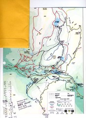
OK. I started this thread. So I continue to fine tune my trip and it is shaping up into one heckuva venture. The hike I really want critiqued now is this one of the Dixville Notch area. See the map and tell me if this is doable. I saw a post on this website by Dennis C. indicating that the trail along Sanguinary is closed. But it was posted back on June 1, 2005, so I am concerned. Does anyone know anything about its status? See this thread. Arghman shows the Balsams area map overlaid with my route in the next post on the next page. Click on the map two times to get a blown up image that makes it clear what my attempted route currently is. I am sorry that it is a little blurred and a bit hard on the eyes but it does show my proposed route. The starting point will be the Flume Brook Picnic Area east of the Balsams. Also, is my mileage figure of approx. 18 miles accurate? I based my figures on the mileages of the trails on the original Balsams map on the web, which includes trail mileages. Does anyone know if I am close to accurate on these mileages?

BTW. The yellow envelope was a fake out of Adobe Photoshop to tease it into thinking it is a color document otherwise I get a black & white text art document when copying.
 
Last edited:
last word is that SST open

re:I saw a post on this website by Dennis C. indicating that the trail along Sanguinary is closed

K.R. Nilsen sent this update to the CT list in Aug 2005:

CLOSED SIGNS ON THE SST TAKEN DOWN
The Sanguinary Summit Trail is open once again. And now the closed signs
that we had put up have been taken down. On the northern reaches of the
ridge, the new logging road cuts in for a quarter mile. There are new
yellow-topped grade posts standing along the way and blazing has been
repainted so all you have to do is follow the yellow and you’ll get where
you want to go.
 

Latest posts

Top