Mudrat
Member
Disclaimer
Details
Duration:15 hours; 8:00 am – 11:00 pm
Benchmarks: Bushwhack begins at cirque drainage: 10:30 a.m., Slide Bottom: 3:00 p.m., Summit: 5:45
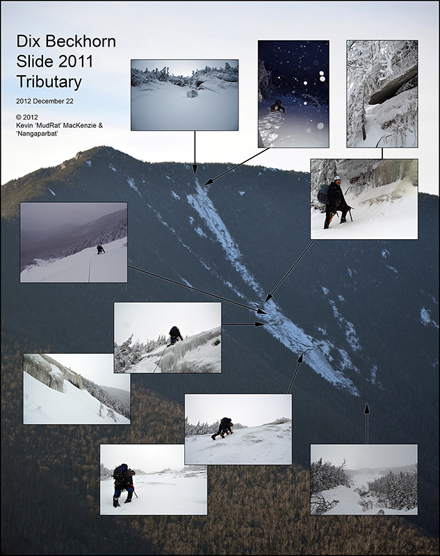
Route: N. Fork Boquet herd path - Dix East Face drainage - Beckhorn Slide (Irene 2011 Tributary) - Summit - Trail to Round Pond
Total Mileage/Vertical Ascent: Approximately 11 mi. / 4200'
Trail Conditions: 2" packed - 24" snow with deeper drifts.
Temperature: 30's - teens
Partner: Nangaparbat
Diet: 2 eggs, protein drink, a dozen or so starburst, piece banana break, 2 powerbars, 2 e-gel packs, 3 liter of water
Clothing: Capilene, Columbia Titanium snow pants, Rain jacket (shell), primaloft jacket while climbing, wicking top, BD sabretooth crampons, Koflach Degre boots, OR Absolute Zero mitts/Burton mitts.
Pack Weight: about 30-35 lbs.
PICTURES
Background photo taken from Spotted Mtn. in November of 2012.
Intro
Greg Karl and 'Mastergrasshopper' climbed the new track of the Beckhorn Slide in October of 2011. I knew it was steep from their account. Their approach was a bit more creative than ours, however. We planned to follow the primary drainage westward, counting the streams entering from each to keep our bearings.
NP and I had been discussing the climb in winter for several months. He'd been watching the conditions since November to see if the ice was 'in'. I finally had a break from work, so we took the first opportunity to make the climb. The mild winter weather would be a bonus for the long approach. In hindsight, I can hardly imagine doing this in historic winter weather. We knew it would be a long day, but didn't fully grasp how grueling it would be. It may not look like winter below about 1000' in elevation, but it's full-on winter above about 3000'.
Approach
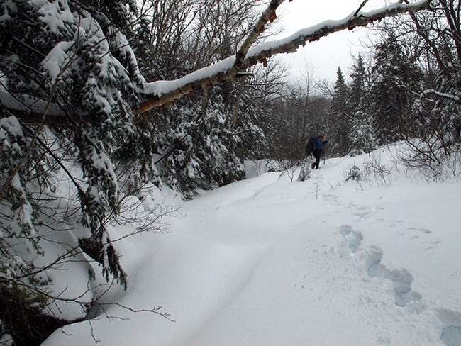
NP awoke at 4:00 a.m. and drove to the Round Pond Trailhead where we met. We then left a car and drove to the North Fork Boquet parking area. We began hiking at 8:00 a.m. The stream in my yard was running high the night before so I expected the river to be up slightly. This could and would affect the crossing. Warmer temps kept the river from freezing over and each of the rocks forming the route to the other side was capped with a bit of crusty snow and ice. A 5 foot gap channeling the main flow necessitated a little creativity. I should have know the day would be 'interesting' when I had to leap across to a large flat rock. I landed on my belly with knees bent so my feet didn't get wet. I think I heard NP snickering behind me. He was hold a log that I'd pulled partway across the river and handed the end to me. We set it in place as a bridge for him to use in lieu of a leap. As he said, "A fall in the river would end the day." The trail was broken for the next segment, roughly three miles to the confluence with Dix' Eastern Cirque drainage.
The confluence with the Boquet is strewn with boulders and obvious, but a bit deceptive in that it parallels the South Fork Boquet before veering off to the right. The route along the main branch then climbs roughly west for a couple miles to the base of the slide. This all sounds easy, but various streams enter from both sides as well as the maze of drainages closer to the slide.
Due to the several inches of snow covered by a thin crust we decided to follow along the top of the right-hand side rather than in the stream. It's a beautiful area with a the wide stream flowing some 100 feet below the level of our route atop its banks. Open hardwoods including beach and striped maple made the gentle climb delightful. As I said, there wasn't much snow on the ground but punching through the crust became wearisome over time so we switched leads every 10 minutes or so. Up and to our right, open rock sat like so many sentinels overlooking the gateway to Dix.
It took well over an hour to reach the first stream that entered the drainage from the NW. Like below, it paralleled the primary flow before breaking off to the right. Beyond, the terrain became a bit more tiresome, steeper with more glacial erratics and obstacles. Pine trees became more abundant along with the depth of the snow, now 8-10 inches in depth. This should have been a sign of things to come...
NP noted our slow rate of progress and I silently considered how much longer it might take at our pace. It was now snowing which hindered line-of-sight navigation. Only the ridge to our left, over which sat Grace, was visible. Every step took us into more conifers, each encased by skirt of snow. We were post-holing to a depth of about mid-shin by this point. NP relieved me when needed and visa-versa. Such was our progress for hours on end...a difficult winter bushwhack however atypical the weather has been.
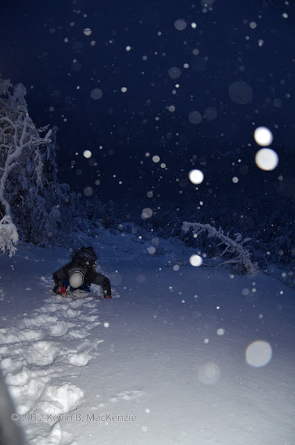
NP rattled off the time once again...about 2 p.m. We were within 1/2 mile of the base and we knew the trek would only get more arduous. The drainage stream became more recessed with significantly steeper banks and the trees grew more tightly together the closer we got. On NP's suggestion, we tried climbing via the drainage. This was a good call and the area harbored some slab under the snow. We were fighting 18"-20" of snow and plunging deeper on occasion. We were also in an area of intertwining stream beds, some leading to smaller slides to either side. A few hundred feet up the wrong one I caught another glimpse of the Beckhorn (we'd seen it earlier). It was close at hand as the crow flies...some 500 linear feet away. The view disappeared after a few steps, but we knew how to change our direction.
An area with less snow in the drainage below the slide.
I led us back into the woods and over to a narrow boulder-ridden drainage. Plunging to my waist once or twice, I became exhausted and muttered that we needed the protection and sure footing of the forest even if it was tightly knit. This worked for a bit before entering yet another drainage. I kept breaking trail while NP put on some gortex pants. Stopping to catch my breath, I waited and contemplating our choices. We needed to be of one mind to keep safe. Realistically, how tired were each of us? Did we need to retreat? Only 400' stood between our object...followed by a climb of over 700 vertical feet. "Summit fever" can't dictate a decision this far into the day. Had I been solo, I'd have turned back and followed my tracks out in the dark, but I drew confidence from NP. He re-enforced what I believed - the fastest way to a path was upward. A few minutes later, we exited the forest at the bottom of the Beckhorn Slide...7 hours after leaving the car and 4 hours after leaving the herd path to Grace. It was 3:00 p.m., in the 20's, snowing and gusting from the east.
Beckhorn Slide (2011 Tributary)
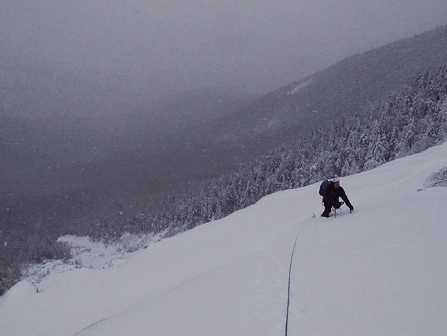
It took about 30 minutes to rest, eat and ready our gear: crampons, harnesses, ice screws, rope etc. Some would likely not be necessary, but it all needed to be at the ready. NP groaned while assessing the snow on the slide. We'd stay near the left-hand edge since the possibility of an avalanche was of concern. The first pitch is less steep than the upper one and vacillated between crusty snow and ice. Crampons caught on the underlying ice well in some sections while others amounted to "trail breaking" on an incline. Icy bulges and ledges clothed in icicles loomed above. NP led the way and I felt my strength return with the thrill of the climb. The numerous slides riddling the cirque surrounded us behind a gray blanket of snow and gusting spindrift.
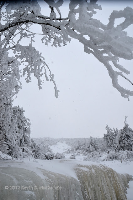
NP readied the rope once we reached the ledges. I followed and comfortably ascended the tiers; it looked like the rope wouldn't be needed. We were now standing on a wide snowfield below the line leading directly to the Beckhorn and had to traverse over to the 2011 tributary. Again NP led. Instead of following his tracks, I walked slightly higher on a parallel track..."whump...". The snow settled and I felt a chill run up my spine. Nothing further occurred, but my awareness was certainly heightened. Soon after, we were standing among a bit of slide debris below the 2011 tributary. Relaxing slightly, I enjoyed the views; the slide track below, the east ridge slides, the nearby ledges and ice laden trees.
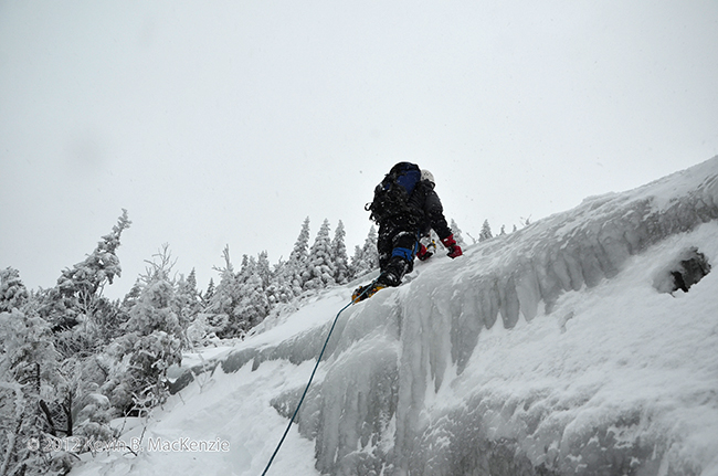
NP climbing the central ledges.
Details
Duration:15 hours; 8:00 am – 11:00 pm
Benchmarks: Bushwhack begins at cirque drainage: 10:30 a.m., Slide Bottom: 3:00 p.m., Summit: 5:45
Route: N. Fork Boquet herd path - Dix East Face drainage - Beckhorn Slide (Irene 2011 Tributary) - Summit - Trail to Round Pond
Total Mileage/Vertical Ascent: Approximately 11 mi. / 4200'
Trail Conditions: 2" packed - 24" snow with deeper drifts.
Temperature: 30's - teens
Partner: Nangaparbat
Diet: 2 eggs, protein drink, a dozen or so starburst, piece banana break, 2 powerbars, 2 e-gel packs, 3 liter of water
Clothing: Capilene, Columbia Titanium snow pants, Rain jacket (shell), primaloft jacket while climbing, wicking top, BD sabretooth crampons, Koflach Degre boots, OR Absolute Zero mitts/Burton mitts.
Pack Weight: about 30-35 lbs.
PICTURES
Background photo taken from Spotted Mtn. in November of 2012.
Intro
Greg Karl and 'Mastergrasshopper' climbed the new track of the Beckhorn Slide in October of 2011. I knew it was steep from their account. Their approach was a bit more creative than ours, however. We planned to follow the primary drainage westward, counting the streams entering from each to keep our bearings.
NP and I had been discussing the climb in winter for several months. He'd been watching the conditions since November to see if the ice was 'in'. I finally had a break from work, so we took the first opportunity to make the climb. The mild winter weather would be a bonus for the long approach. In hindsight, I can hardly imagine doing this in historic winter weather. We knew it would be a long day, but didn't fully grasp how grueling it would be. It may not look like winter below about 1000' in elevation, but it's full-on winter above about 3000'.
Approach
NP awoke at 4:00 a.m. and drove to the Round Pond Trailhead where we met. We then left a car and drove to the North Fork Boquet parking area. We began hiking at 8:00 a.m. The stream in my yard was running high the night before so I expected the river to be up slightly. This could and would affect the crossing. Warmer temps kept the river from freezing over and each of the rocks forming the route to the other side was capped with a bit of crusty snow and ice. A 5 foot gap channeling the main flow necessitated a little creativity. I should have know the day would be 'interesting' when I had to leap across to a large flat rock. I landed on my belly with knees bent so my feet didn't get wet. I think I heard NP snickering behind me. He was hold a log that I'd pulled partway across the river and handed the end to me. We set it in place as a bridge for him to use in lieu of a leap. As he said, "A fall in the river would end the day." The trail was broken for the next segment, roughly three miles to the confluence with Dix' Eastern Cirque drainage.
The confluence with the Boquet is strewn with boulders and obvious, but a bit deceptive in that it parallels the South Fork Boquet before veering off to the right. The route along the main branch then climbs roughly west for a couple miles to the base of the slide. This all sounds easy, but various streams enter from both sides as well as the maze of drainages closer to the slide.
Due to the several inches of snow covered by a thin crust we decided to follow along the top of the right-hand side rather than in the stream. It's a beautiful area with a the wide stream flowing some 100 feet below the level of our route atop its banks. Open hardwoods including beach and striped maple made the gentle climb delightful. As I said, there wasn't much snow on the ground but punching through the crust became wearisome over time so we switched leads every 10 minutes or so. Up and to our right, open rock sat like so many sentinels overlooking the gateway to Dix.
It took well over an hour to reach the first stream that entered the drainage from the NW. Like below, it paralleled the primary flow before breaking off to the right. Beyond, the terrain became a bit more tiresome, steeper with more glacial erratics and obstacles. Pine trees became more abundant along with the depth of the snow, now 8-10 inches in depth. This should have been a sign of things to come...
NP noted our slow rate of progress and I silently considered how much longer it might take at our pace. It was now snowing which hindered line-of-sight navigation. Only the ridge to our left, over which sat Grace, was visible. Every step took us into more conifers, each encased by skirt of snow. We were post-holing to a depth of about mid-shin by this point. NP relieved me when needed and visa-versa. Such was our progress for hours on end...a difficult winter bushwhack however atypical the weather has been.
NP rattled off the time once again...about 2 p.m. We were within 1/2 mile of the base and we knew the trek would only get more arduous. The drainage stream became more recessed with significantly steeper banks and the trees grew more tightly together the closer we got. On NP's suggestion, we tried climbing via the drainage. This was a good call and the area harbored some slab under the snow. We were fighting 18"-20" of snow and plunging deeper on occasion. We were also in an area of intertwining stream beds, some leading to smaller slides to either side. A few hundred feet up the wrong one I caught another glimpse of the Beckhorn (we'd seen it earlier). It was close at hand as the crow flies...some 500 linear feet away. The view disappeared after a few steps, but we knew how to change our direction.
An area with less snow in the drainage below the slide.
I led us back into the woods and over to a narrow boulder-ridden drainage. Plunging to my waist once or twice, I became exhausted and muttered that we needed the protection and sure footing of the forest even if it was tightly knit. This worked for a bit before entering yet another drainage. I kept breaking trail while NP put on some gortex pants. Stopping to catch my breath, I waited and contemplating our choices. We needed to be of one mind to keep safe. Realistically, how tired were each of us? Did we need to retreat? Only 400' stood between our object...followed by a climb of over 700 vertical feet. "Summit fever" can't dictate a decision this far into the day. Had I been solo, I'd have turned back and followed my tracks out in the dark, but I drew confidence from NP. He re-enforced what I believed - the fastest way to a path was upward. A few minutes later, we exited the forest at the bottom of the Beckhorn Slide...7 hours after leaving the car and 4 hours after leaving the herd path to Grace. It was 3:00 p.m., in the 20's, snowing and gusting from the east.
Beckhorn Slide (2011 Tributary)
It took about 30 minutes to rest, eat and ready our gear: crampons, harnesses, ice screws, rope etc. Some would likely not be necessary, but it all needed to be at the ready. NP groaned while assessing the snow on the slide. We'd stay near the left-hand edge since the possibility of an avalanche was of concern. The first pitch is less steep than the upper one and vacillated between crusty snow and ice. Crampons caught on the underlying ice well in some sections while others amounted to "trail breaking" on an incline. Icy bulges and ledges clothed in icicles loomed above. NP led the way and I felt my strength return with the thrill of the climb. The numerous slides riddling the cirque surrounded us behind a gray blanket of snow and gusting spindrift.
NP readied the rope once we reached the ledges. I followed and comfortably ascended the tiers; it looked like the rope wouldn't be needed. We were now standing on a wide snowfield below the line leading directly to the Beckhorn and had to traverse over to the 2011 tributary. Again NP led. Instead of following his tracks, I walked slightly higher on a parallel track..."whump...". The snow settled and I felt a chill run up my spine. Nothing further occurred, but my awareness was certainly heightened. Soon after, we were standing among a bit of slide debris below the 2011 tributary. Relaxing slightly, I enjoyed the views; the slide track below, the east ridge slides, the nearby ledges and ice laden trees.
NP climbing the central ledges.