1HappyHiker
Well-known member
OK . . . call it an obsession, or a fixation, or a fascination, or whatever! But, I’ve been on this personal mission to find a good viewpoint of “The Captain”. I had other plans for Friday (28-Aug) that didn’t materialize and so I took the opportunity to continue my quest.
Since it was already approaching noon, I had to quickly check GoogleEarth, gather some elevation data, etc, and print off some maps. Then, I loaded up my mountain bike and headed off to the trailhead at the end of Sawyer River Road. From the trailhead, I rode my bike to the end of the forest road that heads off in a northwesterly direction toward “The Captain”. Once at the end of the road, I ditched my bike in the woods and headed off on-foot along a bootleg trail which I’m told is used by rock climbers to access “The Captain”. I followed the bootleg trail for about 45 minutes and then bushwhacked for about another 45 minutes to a small ledge located at about 2600 ft elevation on the northern wall of the ravine where “The Captain” resides.
Although there might still be even better spots to view and photograph “The Captain”, I’m satisfied with the results of today’s adventure. And so, this particular quest ends (at least for now!
 ).
).
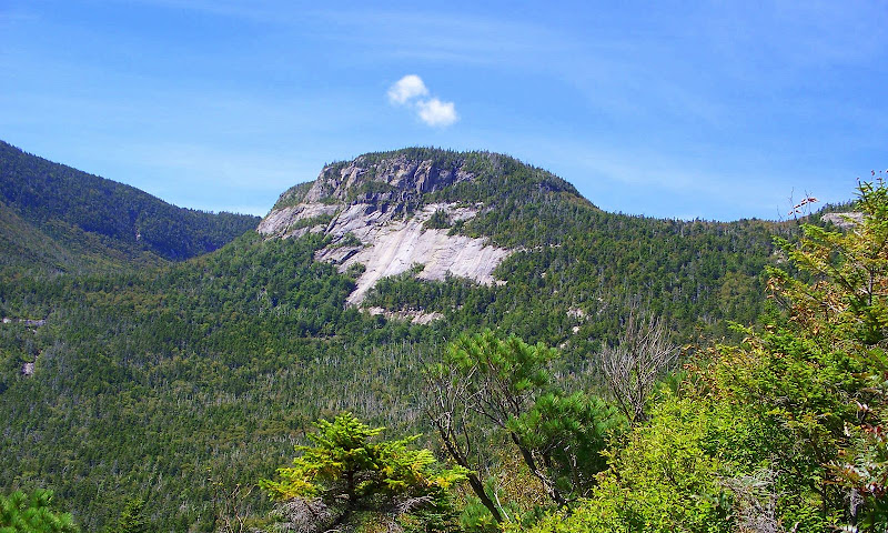
The photo below shows the view of “The Captain” that I was able to capture. I’m truly not fishing for praise for the image I captured.
My intent is merely to share it with you since there are so few photos that are posted of this particular spot in the Whites.

1HappyHiker
Since it was already approaching noon, I had to quickly check GoogleEarth, gather some elevation data, etc, and print off some maps. Then, I loaded up my mountain bike and headed off to the trailhead at the end of Sawyer River Road. From the trailhead, I rode my bike to the end of the forest road that heads off in a northwesterly direction toward “The Captain”. Once at the end of the road, I ditched my bike in the woods and headed off on-foot along a bootleg trail which I’m told is used by rock climbers to access “The Captain”. I followed the bootleg trail for about 45 minutes and then bushwhacked for about another 45 minutes to a small ledge located at about 2600 ft elevation on the northern wall of the ravine where “The Captain” resides.
Although there might still be even better spots to view and photograph “The Captain”, I’m satisfied with the results of today’s adventure. And so, this particular quest ends (at least for now!
The photo below shows the view of “The Captain” that I was able to capture. I’m truly not fishing for praise for the image I captured.
My intent is merely to share it with you since there are so few photos that are posted of this particular spot in the Whites.

1HappyHiker
Last edited:


![Grand Canyon, North and South Rims [Grand Canyon National Park] (National Geographic Trails Illustrated Map)](https://m.media-amazon.com/images/I/419Y-ycyVUL._SL500_.jpg)


![Yellowstone National Park [Map Pack Bundle] (National Geographic Trails Illustrated Map)](https://m.media-amazon.com/images/I/51kGuJ72qjL._SL500_.jpg)


![Grand Teton Day Hikes and National Park Map [Map Pack Bundle] (National Geographic Trails Illustrated Map)](https://m.media-amazon.com/images/I/41DB0jvRnbL._SL500_.jpg)


