On Sunday, I made my 7th trip to Vermont in 10 months to collect Abraham and Ellen. These were the last two peaks in VT for the NE67/NEHH.
I would have preferred doing the gap-to-gap traverse, but the car spot is not trivial, so I settled for and out-and-back from Lincoln Gap (11.6 miles, 3750', 6:30.) I wanted to avoid the Columbus Day onslaught in the Whites, although I met plenty of people today, and parking was tight in Lincoln Gap by the time I was heading home. The drive to/from Lincoln Gap was a bit longer since 107 is still listed as closed. Instead, I took 89 to exit 9 and followed 100B south to 100 to Lincoln Gap Road. It was a beautiful day for a hike, and for a drive as well. I must admit I was jealous of all the cyclists I saw while I was in my car, and "that part" of me thought that climbing Lincoln Gap on a bike would be a challenge*.
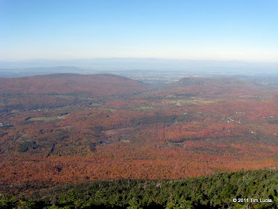
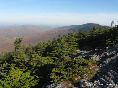
Due west: Champlain & Adirondacks, Northwest to Ellen & Stark
The stretch of The Long Trail from Lincoln Gap to the Battell shelter is a nice wooded walk, with an easy grade. I passed through "The Carpenters", two huge boulders, and a campsite with a wood fire on the way up. As you might expect, there were plenty of people out this weekend, and I met a few of the early risers on their way down. The shelter itself had a decent crew enjoying breakfast, and was vacated when I returned in the afternoon. Beyond the shelter, the trail gets steeper, and rockier, and the last few hundred yards are on slabs and rocks with nice views to the south. Upon reaching the summit, there was a cool breeze, and a dozen people enjoying the views - the foliage was spectacular. Although a bit hazy, I could make out the Adirondacks (of which I know little, but I remember Whiteface from Camel's Hump and Mansfield and I could find it easily today) and the Whites, including Franconia Ridge and Moosilauke (80 miles to the east.)
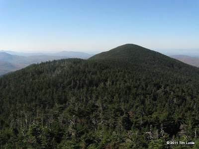
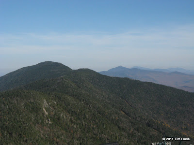
From Lincoln Peak: Little Abe in front of Abraham, Castlerock Peak and Ellen
From Abraham, I headed north along the "Monroe Skyline", crossing a bunch of smaller peaks, each with its own name, and summit sign. Lincoln Peak has a nice observation platform which is accessible from the ski lift. Nobody was home in the morning, but on the way back the lift was bring up droves of people. Continuing through the woods, there are a few view points overlooking some very steep drops, until reaching the Castlerock Peak where there is a small summit building for the skiers. It was unlocked, but empty save a few picnic tables. The Long Trail continues along the ski trails for a bit before re-entering the woods at Holt's Hollow (water here.)
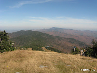
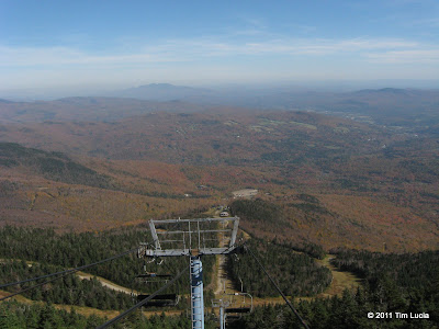
From Ellen/Sugarbush: Camel's Hump and Mansfield, looking down the lift line
The terrain continues to undulate, with mud patches in the sags, and decent views (mostly to the east) here and there. You can see enough to either side to realize you are on a ridge. Cutt's Peak is next, which is a very minor sub-summit of Ellen, and has some nice views from its rocky slabs. Ellen's true summit is viewless, and is marked by a cairn with a stick which, presumably, used to hold a summit sign. Continue on for another 50 yards or so and you come out at the top of Sugarbush North which has excellent views for 270 degrees, blocked only by Ellen itself. Having done Jay peak last, and spending this much time around the ski lifts, I am starting to look forward to ski season.
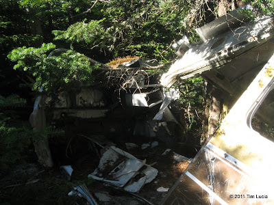
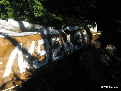
Plane wreck on Abraham
I went back the way I came, although by now there were many more people around, mainly on Lincoln Peak (having taken the lift), and Abraham itself (having day-hiked.) I guess Ellen is not a worth destination unless you are peak-bagging. I did make the very short detour to the plane wreck (documented in here, if you're curious). On Abraham itself, there were easily 100 people and 20 dogs. I did find a somewhat quiet spot part way down the west side to eat a sandwich and enjoy some final views.
All photos
Tim
* for the other cycling nuts, see: http://www.northeastcycling.com/Gap_Climbs.html:

I would have preferred doing the gap-to-gap traverse, but the car spot is not trivial, so I settled for and out-and-back from Lincoln Gap (11.6 miles, 3750', 6:30.) I wanted to avoid the Columbus Day onslaught in the Whites, although I met plenty of people today, and parking was tight in Lincoln Gap by the time I was heading home. The drive to/from Lincoln Gap was a bit longer since 107 is still listed as closed. Instead, I took 89 to exit 9 and followed 100B south to 100 to Lincoln Gap Road. It was a beautiful day for a hike, and for a drive as well. I must admit I was jealous of all the cyclists I saw while I was in my car, and "that part" of me thought that climbing Lincoln Gap on a bike would be a challenge*.


Due west: Champlain & Adirondacks, Northwest to Ellen & Stark
The stretch of The Long Trail from Lincoln Gap to the Battell shelter is a nice wooded walk, with an easy grade. I passed through "The Carpenters", two huge boulders, and a campsite with a wood fire on the way up. As you might expect, there were plenty of people out this weekend, and I met a few of the early risers on their way down. The shelter itself had a decent crew enjoying breakfast, and was vacated when I returned in the afternoon. Beyond the shelter, the trail gets steeper, and rockier, and the last few hundred yards are on slabs and rocks with nice views to the south. Upon reaching the summit, there was a cool breeze, and a dozen people enjoying the views - the foliage was spectacular. Although a bit hazy, I could make out the Adirondacks (of which I know little, but I remember Whiteface from Camel's Hump and Mansfield and I could find it easily today) and the Whites, including Franconia Ridge and Moosilauke (80 miles to the east.)


From Lincoln Peak: Little Abe in front of Abraham, Castlerock Peak and Ellen
From Abraham, I headed north along the "Monroe Skyline", crossing a bunch of smaller peaks, each with its own name, and summit sign. Lincoln Peak has a nice observation platform which is accessible from the ski lift. Nobody was home in the morning, but on the way back the lift was bring up droves of people. Continuing through the woods, there are a few view points overlooking some very steep drops, until reaching the Castlerock Peak where there is a small summit building for the skiers. It was unlocked, but empty save a few picnic tables. The Long Trail continues along the ski trails for a bit before re-entering the woods at Holt's Hollow (water here.)


From Ellen/Sugarbush: Camel's Hump and Mansfield, looking down the lift line
The terrain continues to undulate, with mud patches in the sags, and decent views (mostly to the east) here and there. You can see enough to either side to realize you are on a ridge. Cutt's Peak is next, which is a very minor sub-summit of Ellen, and has some nice views from its rocky slabs. Ellen's true summit is viewless, and is marked by a cairn with a stick which, presumably, used to hold a summit sign. Continue on for another 50 yards or so and you come out at the top of Sugarbush North which has excellent views for 270 degrees, blocked only by Ellen itself. Having done Jay peak last, and spending this much time around the ski lifts, I am starting to look forward to ski season.


Plane wreck on Abraham
I went back the way I came, although by now there were many more people around, mainly on Lincoln Peak (having taken the lift), and Abraham itself (having day-hiked.) I guess Ellen is not a worth destination unless you are peak-bagging. I did make the very short detour to the plane wreck (documented in here, if you're curious). On Abraham itself, there were easily 100 people and 20 dogs. I did find a somewhat quiet spot part way down the west side to eat a sandwich and enjoy some final views.
All photos
Tim
* for the other cycling nuts, see: http://www.northeastcycling.com/Gap_Climbs.html:
Lincoln gap from the east has sustained 20% grades, max’ing at 24%. It is perhaps the hardest climb in all of New England.

Last edited:
