Another hidden pond?

vftt.org

Help Support vftt.org:

This site may earn a commission from merchant affiliate links, including eBay, Amazon, and others.

Hillwalker

Super Moderator
Staff member
Joined
Feb 2, 2005
Messages
861
Reaction score
121
Location
44.55066, -70.32336
After posting the thread about the circumnavigation of the Captain, I started thinking about a little pond that I had wanted to visit, but never found time.
Has any one ever been to this one? It seems to be tucked into a fold of land dropping down from Bondcliff towards Whitewall Brook. Dimensions approximately 1000 ft by 180 feet. Depth? Trout?
 

Attachments

  • Zealand little hidden pond.JPG
    Zealand little hidden pond.JPG
    116 KB
  • Zealand Pond hidden B.JPG
    Zealand Pond hidden B.JPG
    104.8 KB
I was there in June of 2022. Can't say anything as to fishing, but it's probably 10-12' deep max. Came in from below, as I'd been out on the far reaches of the rail grade beyond Camp 23. Stayed just west of the outlet brook, and didn't find bad woods. Glimpses of Whitewall from the shoreline on the west side of the pond, and an interesting vernal pool between there and Zeacliff Trail.
 

Attachments

  • PXL_20220605_160652882.jpg
    PXL_20220605_160652882.jpg
    332.5 KB
I've never been, but it caught my interest in October 2024 when I was hiking through the notch on the AT. I've always known it was there prior to October, but with the fall color providing more contrast, I could see a long break in the tree line where the pond sits.
I'd been out on the far reaches of the rail grade beyond Camp 23. Stayed just west of the outlet brook, and didn't find bad woods.
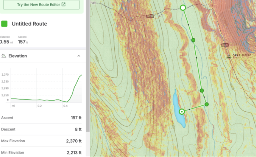
I plotted this rough course out in October following the old rail grade, is this roughly the way you got up there? I have been planning to give it go sometime this year.

408d1dd1bc9c29edd0d1cd6ea95d8f4c.png
 
is this roughly the way you got up there?

I came in from the south, crossing over the North Fork below its confluence with Whitewall Brook. The outlet is on the south end, and the brook isn't shown on the maps, but the contours should give you an idea where it is. I hugged the west side of the pond, and stayed on contour due north to hit Zeacliff Trail. Haven't poked around for the old west side rail grade coming down from the vicinity of Zealand Hut.
 
I was there in June of 2022. Can't say anything as to fishing, but it's probably 10-12' deep max. Came in from below, as I'd been out on the far reaches of the rail grade beyond Camp 23. Stayed just west of the outlet brook, and didn't find bad woods. Glimpses of Whitewall from the shoreline on the west side of the pond, and an interesting vernal pool between there and Zeacliff Trail.

That's a really nice photo, bro. I love the lines.
 
My cartography notes for that pond mentioned a possible reference in the Echo, so I looked it up. From the White Mountain Echo, August 23rd, 1879

"The scenery along the route is simply grand. The Notch, formed by the two mountains I have mentioned before, is superb. Mount Hastings, from the base to the summit, is a mile and a quarter high, and Mount Thompson is at least, if not more, than two miles. Mount Hastings runs the whole length of the Notch, while Mountain Thompson ends about a mile from the southern outlet at a beautiful sheet of water, known to few but Thompson, right at the foot of the mountain, and which I have named Lake Thompson, in honor of the old man himself. This lake is about 1200 feet long by 200 feet broad."

Mount Thompson is now called Zeacliff. From Appalachia
https://digitalcommons.dartmouth.edu/cgi/viewcontent.cgi?article=1368&context=appalachia

Mount Hastings is now called Whitewall.
 
I believe that the long bench is mapped as a lateral moraine on the Crawford 7.5’ quadrangle surficial geologic map, but need to check. When I was younger, I had plans to obtain a sediment core from the pond for radiocarbon dating to determine a minimum age estimate for the “moraine,” but sadly that did not happen.
 

Latest posts

Top