Chocorua loop?

vftt.org

Help Support vftt.org:

This site may earn a commission from merchant affiliate links, including eBay, Amazon, and others.

hikes-with-him

New member
Joined
Feb 5, 2009
Messages
479
Reaction score
51
Location
Small Town in Maine
Hi there...

Hoping to do Chocorua on Saturday...should be a georgeous day...

Thinking Up Piper trail and down...um...the other side (can't remember the trail names but I think one is Liberty...) back to the pipe trail for a loop.

Seems the piper trail is fine for up...but, what about the others to go down? haven't heard/read anything since the storm.

Thanks.
 
I can report that the Piper trail is in good condition. No real storm damage. Minor erosion has been patched. I have heard from Chinooktrail that Liberty is in OK condition as well. Chocorua didn't have the damage seen in other areas of the whites.
 
Be aware that give the forecast and leaf conditions Chocurua is going to be full of hikers and particualry a lot of underequipped inexperienced hikers. You should start practicing "excuse me" and " can I go pass you" as you will be saying it on a frequent basis. Expect a line at the summit.

About the only way to mitigate the crowds is to go real early, preferably so you will summit by 10:30 AM. You will hit the crowds on the way down but it is usually easier to pass.
 
If you're up for a good deal more mileage as well as going up over the Sisters, but also avoiding a lot of the crowds and getting a lot of terrific open views on the way up, I'd highly recommend Piper Trail, to Nickerson Ledge Trail, to Carter Ledge Trail, to Middle Sister Trail, to Piper Trail, to the summit, to Liberty Trail, past the cabin to Hammond Trail, to Weetamoo Trail, back to Piper Trail to the trailhead.

I'm sorry I don't have a book or maps here at work to give you any estimated time or mileage, but I think it's around 9 to 9-1/2 miles. Our group did it in 7:30 at a mellow pace including hanging out on the summit for a while.

Topo, 3-D, view.

It's a terrific loop that I'd never done before being brought on it last year and now is my favorite route for Chocorua.
 
Has anyone ever done a Bolles/Bee Line/Champney Falls loop? I would guess the trails lightly traveled on the west side. The views, probably not as good as the sisters/ledges. Champney Falls is one of my favorite trails in the whites though. Maybe I'll check it out on my own.

If you get to the summit early and the conditions are right, you can see the Atlantic around 9-10am this time of year if I'm not mistaken. I caught it last year around this time and it was spectacular!

And Michael, I'm going to have Peter Gabriel in my head all day now... :eek:
 
Has anyone ever done a Bolles/Bee Line/Champney Falls loop? I would guess the trails lightly traveled on the west side. The views, probably not as good as the sisters/ledges. Champney Falls is one of my favorite trails in the whites though. Maybe I'll check it out on my own.

I hiked that loop on a warm day in July three or four years ago - up Champney and down by Brook, Bee Line and Bolles. I hiked up Champney with a group that goes up there every year, and I took the alternate route down just because I had never hiked "new" Bee Line or Bolles. (I wanted to redline all the trails that go anywhere near Chocorua, which I've since completed.)

The original Bee Line, which I hiked a couple of times in the early '70s, was aptly named. It left from the summit and went straight down over boulders in a bee-line. That upper portion was abandoned - in the '80s? - and to get to the upper end of the present "Bee Line" you have to descend the Brook Trail for over half a mile. It no longer deserves its name, but is a very attractive woods walk to the Bolles Tr.

Bolles has more ups and downs than you would think from looking at the small-scale AMC map, so keep that in mind. It is primarily a snowmobile trail and had some wet sections when I hiked. It also lacks the ledge views you get from loops on the east side that include Carter L. and/or some or all the Sisters. That said, I had it to myself on a sunny Saturday in July and it had a certain rustic charm - some sections passed through meadows that seemed 19th Century.
 
And Michael, I'm going to have Peter Gabriel in my head all day now... :eek:

My devious plan has come to fruition! Now to retreat to my secret hideaway under the summit of Chocorua...
 
GREAT INFO!!! Thanks!

Actually, that loop was what we were looking at doing...now, we know it's a good one!

And, as for time...he he...we are early birds. We usually get UP by 2 am to get to the trailhead by 6 am...looks like about 5 miles to the summit...puts us there around 10 - 1030ish! We usually have a pretty quite trip up...and meet ALL the crowds on the way down.

THANKS for the info :)
 
One comment on the Champney, Beeline and Bolles loop. Check out the contrours on the map. When you come to the intersection of Beeline with Bolles, you are on the south side of the watershed and have to hike back up to the top of the watershed to the north and then back down again to the Kanc. It is a nice loop but it is easy to forget the extra elevation at the end of the day after coming down Chocurua. I definitely expect you wont see a lot of traffic on it.
 
Be aware that give the forecast and leaf conditions Chocurua is going to be full of hikers and particualry a lot of underequipped inexperienced hikers. You should start practicing "excuse me" and " can I go pass you" as you will be saying it on a frequent basis. Expect a line at the summit.

It's nearing the time of year I always think about bringing some extra flashlights and selling them along the trail as darkness approaches before the under-equipped and inexperienced know where their daylight went.

I like coming out late but this way I could perhaps make a few bucks and not have to escort them out or worry about them (I can't help it, I'm a mom).
 
A few years ago I was on the Piper trail. Coming down in the afternoon I turned around TWO groups that had descended the wrong trail! One near the open ledges a few hundred yards south of the intersection, but one group was way down past the rock steps and switchbacks! Both had taken a wrong turn and come down Piper when they were looking for Champney Falls. Must have been a late night for them. :(

Also, that same day, at about 1-2 in the afternoon I came across a large group heading up. One of the adults said something like "we must be getting close to the top, right?". They were about 2 miles in. His grin faded a bit when I told him he was halfway.

Come to think of it, this was the same day I was almost attacked by a black lab on the trail. It was an odd day in the mountains, for sure.
 
I met a scout group (with Eagle scouts) at the bottom of Piper who should have been on Champney. From reading Appalachia, this seems to be a common occurrence.
 
I met a scout group (with Eagle scouts) at the bottom of Piper who should have been on Champney. From reading Appalachia, this seems to be a common occurrence.

Conversely, shortly after we got back to the Champney lot one summer Saturday a number of years ago, a newlywed couple arrived, looking puzzled at the changed appearance of the Piper lot. That must be a harder mistake to make, since you would have to ignore the signs for the C. Falls spur loop. On the other hand, newylweds should be cut more slack than Eagle Scouts.

We were going their way and gave them a lift.
 
Ok...sounds like a GREAT HIKE!!! And I'll watch for that sign when heading off the summit...we're doing that awesome sounding loop that SHOULD get us back to the piper trailhead.

Now...how to FIND that trailhead. The book isn't really clear. Is it RIGHT OFF Rte 16...or off of a side road off 16?

We'll be coming in at about 6am...so...may be a little dark and hard to find...

Thanks.
 
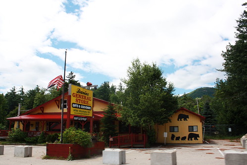
You will see this store on your left coming North on 16.

3884321493_9e6d0d191d.jpg


The trailhead is on your left IMMEDIATELY after the store. The road is called Piper Trail Road if I'm not mistaken. It's a dirt road about 100 yards long.
 
You will see this store on your left coming North on 16.

Or on your right, and the road is just before the store if you are coming FROM the North. It will be very obvious when you get there. The store is closed, so don't count on picking up anything you might need there.
 
The parking is down a small dirt road with a big honkin' brown hiker symbol sign. Be sure to not end up in a driveway. It's a good-sized lot, but will certainly fill up this weekend. Good thing you're early risers!

As for the hideaway, have you seen the Austin Powers films? :)
 
If you're up for a good deal more mileage as well as going up over the Sisters, but also avoiding a lot of the crowds and getting a lot of terrific open views on the way up, I'd highly recommend Piper Trail, to Nickerson Ledge Trail, to Carter Ledge Trail, to Middle Sister Trail, to Piper Trail, to the summit, to Liberty Trail, past the cabin to Hammond Trail, to Weetamoo Trail, back to Piper Trail to the trailhead.

I'm sorry I don't have a book or maps here at work to give you any estimated time or mileage, but I think it's around 9 to 9-1/2 miles. Our group did it in 7:30 at a mellow pace including hanging out on the summit for a while.

Topo, 3-D, view.

It's a terrific loop that I'd never done before being brought on it last year and now is my favorite route for Chocorua.


Those are some sweet maps. I love the 3D view. We are going for it this weekend after looking at your site. We have been wanting to do Chocorua since we moved here. Glad we found a way to do it to avoid the crowds and tag the Sisters. Thanks
 
Also easy to avoid the crowds by not going on a weekend. I've spent hundreds of hours working on Chocorua and spent days out there not meeting another soul (on the busiest trail).
 
Top