GAIA Acquired by Outside Magazine Organization

vftt.org

Help Support vftt.org:

This site may earn a commission from merchant affiliate links, including eBay, Amazon, and others.

ChrisB

Well-known member
Joined
Sep 4, 2003
Messages
1,512
Reaction score
67
Location
Not quite yet
Came as a surprise to me, but there you go.

I used Gaia almost exclusively on many recent hikes in the obscure Belknap region and was amazed at its accuracy and features. The crowdsourced Gaia topo has it all.

To me Gaia seems like a handheld-GPS-killer. Why you'd buy an expensive GPS with the inexpensive Gaia subscription plan available on a yearly basis? I hope Outside doesn't ruin Gaia by milking it for increased profits.
 
I have also begun to relay on Gaia as my primary GPS with the Garmin moved to a backup unit. I find the Gaia user interface far nicer than Garmin. I have had two separate issues Gaia since it was purchase by Outside. Both have been with Outside's request to enter a password though their system to access Gaia.

The first was shortly after Outside purchased Gaia. Arrived at the trail head, no cellular service and opened Gaia. No issues, location and downloaded mapping on Gaia working fine. At some point during the trail run the phone likely received a momentary cellular signal. After that I was locked out of Gaia with a screen that said I would need to sign into Outside with my Gaia password. With no reliably cellular signal to enter password the Garmin comes out to finish the outing.

The second was on the morning of December 28th. I attempted to use Gaia at home on my laptop to planned an afternoon hike that day. I was unable to log in and was prompted that my password was not correct. Request email link to reset password and did so. Still unable to login to Gaia and sent an email off to Outside asking about my login and resetting of my password issues. Oddly Gaia was still working on my phone. Chalked it up to entering the wrong password on laptop. Arrived at the trail head and Gaia on the phone is now asking to enter password for access. I was unable to get Gaia to open with any password. Garmin comes out of the backpack. After the hike and back home read an email from Outside that the server was down that morning and that was likely the cause of your password problems.
 
Not good news.

I really liked how Gaia comported itself as a business and organization. Seemed hip but user oriented. Now, who knows where they are headed.

Your problems seem like collateral damage from Outside Corp. IT dept taking over user access control from Gaia. Happens all the time after a merger unfortunately.

Gaia has a fiesty competitor in AllTrails and users won't hesitate to switch if issues continue to arise.
 
Last edited:
Gaia has a fiesty competitor in AllTrails and users won't hesitate to switch if issues continue to arise.

I have both CalTopo and Gaia subscriptions and had settled on Gaia for overland stuff but will be more than happy to switch back. The OSM layer on Gaia (gaia topo) has the same info as the OSM layer on any other platform. I'll be cancelling Gaia at the first issue I have, that kind of lockout **** happening in the woods is no bueno.
 
It's not like cell phones are inexpensive. Certainly can't rely on always having a a cell signal in many remote regions. Can't run a cell phone for the hundred or so hours on the Yukon 1000 mile canoe race. I can change the battteries daily on my Garmin. During SAR, we use hand held GPS units that easily transfer daily track search coverage data to ranger support computers at the end of the day. They are not going to be able to download track data from everyone's individual phone. I wont give up my Garmin handheld quite yet.
 
> It's not like cell phones are inexpensive.
Yet everyone has one. Not everyone has a hand-held GPS.

> Certainly can't rely on always having a a cell signal in many remote regions.
GAIA and other apps have an offline mode

> Can't run a cell phone for the hundred or so hours on the Yukon 1000 mile canoe race. I can change the battteries daily on my Garmin.
Cell phones can be plugged into an external, rechargeable, battery equipped with the ubiquitous USB port for charging other things as well.

> During SAR, we use hand held GPS units that easily transfer daily track search coverage data to ranger support computers at the end of the day.
The phone is surely no worse and potentially better in the presence of signal as it could display updating tracks in real time. Possibly the software on the ranger's support computer is not updated enough to handle the phone(s), so maybe that needs to be replaced.

> They are not going to be able to download track data from everyone's individual phone.
The phones can upload easily to a shared location (with signal) or over blue tooth or USB (just like the GPS)

> I wont give up my Garmin handheld quite yet.
I'll never carry a Garmin handheld again. Garmin software is terrible. The phone runs circles around it for usability.

Tim
 
What Tim Said.

At the outdoor store I work at a guy came in interested in a Garmin GPS we have on display.

As I helped him my first question was.... "Have you tried using any of the free phone-based navigation apps such as Gaia or AllTrails?"

He had not. I suggested he try one of those first and return if he was still interested in a Garmin.

By and large phones have replaced cameras for general hiking use. Dedicated GPS units are next.

And if you are using a dedicated GPS unit in your car, try Apple's iPhone navigation app. You won't look back.
 
Last edited:
Not everyone has one or wants to be tied to an initially expensive device on an expensive monthly pay plan (individually or within a team organization) . Purchase a handheld once and you are done with the expense. Existing one time purchase (or free) software works very well if you practice how to use it.

A handheld GPS has an offline mode by definition. It always works in offline mode.
What cell phone can operate in map display mode for 24 or more hours while racing without taking time out to connect with external power?

So you think every SAR member as well as state and law enforcement SAR officials should replace the system that everyone understands what they have and that works well now. At the end of the SAR day, no one downloads their tracks to Incident Command with a "shared signal" or blue tooth. Not likely IC is going to universally invest $$$ in new systems or software when what is used now works very well.

I was on a recent SAR incident in a high probability search area for a lost hunter when a couple of state troopers showed up to join me. While contemplating a potential found clue I had just led them to, a radio call came in from a ranger that the subject had been located (down) a short distance (3/4 mile) away from us. He relayed the GPS coordinates to us over the radio, which I manually plotted on my "old school" paper topo map and also entered the coordinates in my Garmin handheld GPS. The troopers also copied the coordinates and pulled out their phones but neither had any clue how to operate them as a map or to insert coordinates to travel toward. They were quite obviously untrained in the use of equipment they were given. So they asked me and I used my relliable Garmin with direction and distance verified with paper topo map and hand held compass to guide them overland to the site. Later, back at the IC, I gave my Garmin to the recording officer who downloaded everything on it (my assigned search block, my track, my saved found potential clue locations) for the record, using standardized universally compatible download and mapping software.
 
What cell phone can operate in map display mode for 24 or more hours while racing without taking time out to connect with external power?


You'd be surprised, apparently. Phones running in offline mode are very efficient. There are ways to connect to external sources that take precisely zero time at all, if needed. You don't even need cables anymore. The Garmin requires a computer, which the phone has made largely unnecessary for many. I haven't had a home machine for years.
 
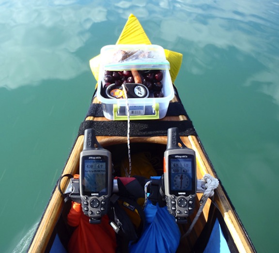
So you say I could replace both of the navigation Garmins mounted in front of me during a race, one displaying a map function, the other a compass function, with two cell phones and never have to be dismounted for charging their batteries wirelessly without cables for at least 24 hours? The entire 1000 mile well studied Yukon race route with each island and turnpoint is presented right there for me to efficiently observe and navigate.

LBQgUyu.jpg


And you say I have no need for a computer ever again? How do I create, write, program, and test such things as an Excel spreadsheet on a tiny phone by using my thumbs on tiny keys that performs well over 3000 complex trigonometric and other function calculations that my pit crew uses to track and predict my current and future locations during races? The hundreds of waypoints created by observing reasonable sized images of race routes on a computer screen are easily loaded into a Garmin. As I have done for 40 years, I use my computer for many other similar program and display tasks, including for developing and displaying presentations and graphics for my professional engineering career work as well as civilian training instructor of skills for DHS, SAR, BSA, and other organizations. I can't imagine how I or anyone else would ever do the same tasks on a telephone. Others may have found a real and useable computer to be obsolete, but not this one.

You probably know better, but I would imagine that working with photoshop graphics without a computer would be pretty difficult to do effectively on a phone.
 
Last edited:
I guess I am hard on cell phones and have friends who are hard on cell phones. My Apple friends speculate that Apple intentionally makes them weak in order to have owners justify frequent replacements. When I buy phone's, the software may be the greatest thing since sliced bread, but GPS units I have messed with appear to be built to a far more rugged standard. Folks give me crap about my mil spec cell phone which resides in an Otter Box with snap on cover and generally is buried in my pack in a low vulnerability pocket. Mil spec phones are rarely offered by cell providers, so my guess is the typical cell user is not going to get a rugged phone and I just do not see a lot of folks with clumsy Otter Boxes on their phones except folks working construction. Therefore, my contention is that folks are getting dependent on somewhat fragile technology.
 
So you say I could replace both of the navigation Garmins mounted in front of me during a race, one displaying a map function, the other a compass function, with two cell phones and never have to be dismounted for charging their batteries wirelessly without cables for at least 24 hours? The entire 1000 mile well studied Yukon race route with each island and turnpoint is presented right there for me to efficiently observe and navigate.

Yes. I do it on overland trips regularly. GAIA on one screen and usually my media display on the other.


That's an expensive compass.
 
Last edited:
I guess I am hard on cell phones and have friends who are hard on cell phones. My Apple friends speculate that Apple intentionally makes them weak in order to have owners justify frequent replacements. When I buy phone's, the software may be the greatest thing since sliced bread, but GPS units I have messed with appear to be built to a far more rugged standard. Folks give me crap about my mil spec cell phone which resides in an Otter Box with snap on cover and generally is buried in my pack in a low vulnerability pocket. Mil spec phones are rarely offered by cell providers, so my guess is the typical cell user is not going to get a rugged phone and I just do not see a lot of folks with clumsy Otter Boxes on their phones except folks working construction. Therefore, my contention is that folks are getting dependent on somewhat fragile technology.

I've carried the same crappy LG phone in an Otter Box (not the snap cover type) on hiking and tenkara trips for the past 4 years. It has spent a lot of time bouncing around boulders and underwater and is only being replaced because it's not 5G. YMMV.
 
Yes. I do it on overland trips regularly. GAIA on one screen and usually my media display on the other.

That's an expensive compass.

One concern I'd have with replacing the Garmins is waterproofness. Can a Garmin survive immersion in water if you flip over? Most cellphones with any type of charging port cannot. I waded into a trout stream with an iPhone in my back pocket and it was dead for a year. I did restart eventually.

Gaia does provide a compass display at the top of the map window. When enabled it draws more battery power however.
 
Smartphones have a lot of advantages - large screens, many sophisticated mapping apps, more power under the hood, wireless connectivity where avaialable. It may be quite tempting to use them as primary navigation tool and I think for a lot of people this works just fine almost all the time.

Personally, I still stick to my handheld gps on longer hikes and here are my reasons for it:
  1. I want my cell phone to be my backup device that I will fall back if I damage or loose my gps
  2. my gps is a lot more rugged that my phone
  3. batteries on cell phones are mostly non-replaceable these days, so if you deplete the charge you need to rely on external battery pack which may be a pain especially in bad weather
  4. software glitches discovered while already on trail may be hard to resolve (it happened to me on a backpacking trip once). Same is true for handheld gps units but their software undergoes fewer changes and I find it generally to be more stable.
  5. touch screen operation in cold weather is unpleasant at best and may not work well in heavy rain, but I guess that depends on a phone model.
 
Yes. I do it on overland trips regularly. GAIA on one screen and usually my media display on the other.


That's an expensive compass.
Please, do not insult me. It is not used as a compass at all. That is a misnomer of how that function is used in a handheld GPS. It is a direction finder, preprogrammed to take me from preplanned point to point on a complex fast current river that has many potential alternate routes to choose from. Only one route is selected as the shortest and/or fastest. Both the map and "compass" functions are preprogrammed by carefully studying maps, my previous year's race experience on that river, and using a real computer (oh the horror of it) to calculate direction/distance between points and then to insert the most efficient route to follow in the GPS during a race. I concede to using these electronic devices for the purpose of efficiently completing the race in first place, as I have done more than once. Not shown in the photo is a book of printed maps with my planned route on them, as is required for me to carry according to YUkon race rules. If the electronics should fail, I can still navigate to finish or to safety with them and the real compass carried in my pocket.

For the past 5 years I have been employed by my state's Division of Homeland Security to teach land navigation techniques to state and local law enforcement officers, Fire, EMTs and SAR teams. You may call me a dinosaur, but no one in those classes is allowed to use a phone based (or any) GPS during the basic field training exercises. Beyond that I have done the same for licensed wilderness guides, adult BSA trek leader guides, and SAR individuals for 25 years. I do include a brief unit on GPS devices, but will not teach or certify field GPS to anyone who has not already sufficiently demonstrated to me their proficiency navigating with paper topo maps and a traditional real compass.
 
Last edited:
* Phone fits in pocket. Battery stays warm. GPS does not fit in pocket. Battery gets cold. GPS shuts off. Advantage - Phone
* GPS, 1.6"x2.2" 160 x 240 pixels. iPhone XR 6.1" (Diag) 1792x828 pixels. Advantage - Phone
* GPS is a GPS. Phone is a GPS, Camera, Communication device, weather station, etc. Advantage - Phone
* GPS floats. Phone does not. Advantage - GPS
* Touch... when wet, the phone definitely is more difficult to operate. However, the GPS is always difficult to operate, using some complex series of buttons as arrows. Gonna give it to the phone on average.
* Both are waterproof enough for hiking use and maybe dropping in a stream - Tie
* If carrying paper map, compass, knowledge to use them, then GPS + Phone + Map is triple redundancy, so which one is least useful??? GPS.
* GPS - maps you loaded a long time ago (using the real computer). Phone - Many layers of maps, some updated in real time, with real tracks showing detours, closures, etc. No brainer - Phone.
* GPS - 1Gb card, 20 tracks, 500 points max each. Phone... 128Gb, unlimited tracks, unlimited points... I don't know, but I'll give this one to the phone.
* I've essentially given up on non-usb-rechargeable batteries. I just won't buy any device that is not usb-rechargeable. GPS uses batteries. Phone is usb-rechargeable AND it can charge other devices... phone wins again.
* Phone can stream live video to my wheelchair bound aunt. GPS can’t.
* Find my phone - wife / kids always know where I am (or was last in range of signal) - GPS... nope
* Newbie/lost/confused hiker... can give them any web site with location and they have map. Or I can give them a screen shot off my phone, where I can also draw on the screen shot to aid them. GPS... nope
* Phone uploads tracks to GAIA and/or Strava and/or ... automatically. GPS... maybe (needs the phone! or a cable and a laptop.)

You do you. I'll do me. HYOH.

Tim
p.s. I have two Garmin GPSes sitting in a box if you want them :)
 
Last edited:
Funny how now gps users are the troglodytes :)

I carry gps, paper map, and cellphone. Use gps almost exclusively...with paper map as a psychological crutch. GPS is used in one way only: To get me from one preloaded waypoint to another (and back.) (Tiny maps on gps or phone screen are of little to no value to me.) I assume that gps is simpler and more robust than cellphone, and have never been disappointed in that judgement. All the rest of the functionality of the gps and especially the phone seems arcane and/or pointless.
 
Funny how now gps users are the troglodytes :)

That's been true forever in just about any space. First it was the 8 track, then VHS and cassette tape, and records, and now CDs and DVDs... Cars, bicycles, skis, ..., 2-stroke, 4-stroke, battery, ... gas/diesel, electric... you name it...

The mobile phone has revolutionized my business and many, many others. In my case, it has also replaced specialized, purpose-built devices. The main advantage being that everyone has one so the market is that big.

Tim
 
* Phone fits in pocket. Battery stays warm. GPS does not fit in pocket. Battery gets cold. GPS shuts off. Advantage - Phone
* GPS, 1.6"x2.2" 160 x 240 pixels. iPhone XR 6.1" (Diag) 1792x828 pixels. Advantage - Phone
* GPS is a GPS. Phone is a GPS, Camera, Communication device, weather station, etc. Advantage - Phone
* GPS floats. Phone does not. Advantage - GPS
* Touch... when wet, the phone definitely is more difficult to operate. However, the GPS is always difficult to operate, using some complex series of buttons as arrows. Gonna give it to the phone on average.
* Both are waterproof enough for hiking use and maybe dropping in a stream - Tie
* If carrying paper map, compass, knowledge to use them, then GPS + Phone + Map is triple redundancy, so which one is least useful??? GPS.
* GPS - maps you loaded a long time ago (using the real computer). Phone - Many layers of maps, some updated in real time, with real tracks showing detours, closures, etc. No brainer - Phone.
* GPS - 1Gb card, 20 tracks, 500 points max each. Phone... 128Gb, unlimited tracks, unlimited points... I don't know, but I'll give this one to the phone.
* I've essentially given up on non-usb-rechargeable batteries. I just won't buy any device that is not usb-rechargeable. GPS uses batteries. Phone is usb-rechargeable AND it can charge other devices... phone wins again.
* Phone can stream live video to my wheelchair bound aunt. GPS can’t.
* Find my phone - wife / kids always know where I am (or was last in range of signal) - GPS... nope
* Newbie/lost/confused hiker... can give them any web site with location and they have map. Or I can give them a screen shot off my phone, where I can also draw on the screen shot to aid them. GPS... nope
* Phone uploads tracks to GAIA and/or Strava and/or ... automatically. GPS... maybe (needs the phone! or a cable and a laptop.)

You do you. I'll do me. HYOH.

Tim
p.s. I have two Garmin GPSes sitting in a box if you want them :)

This is a great comparison and I agree 100%. I've been a laggard moving to the phone for navigation but now that I have changed over my GPS unit has been in a draw. Ease of use is such a huge, huge advantage for a phone that can't be understated. Multiple functions on one device is super convenient and a weight savings.

Battery life I think has ceased to be a comparative factor now with the advances in phone technology, with Android phones at least. (I have several friends with iPhones whose battery doesn't last anywhere near as long as my Samsung). I routinely go out for 8-10 hours hikes in airplane mode with both Gaia running as well as my Zoleo device, and of course taking pictures, and I'll usually still have 60-70% of my battery back at the car. Last Spring I did a 4 day, 3 night hike (not with Gaia to be fair) and using battery save mode and turning my phone off at night I still had 30% of my battery when my wife picked me up on Day 4. I've done long, Winter day hikes with my Garmin GPS where it died after 11-12 hours starting with a full charge. I don't even think this is a conversation anymore.

To be fair to Nessmuk too though I think his use case is a lot more extreme than the average user and the stakes are far higher (SAR rescues, etc) and I think I'd be going with a dedicated GPS in the circumstances he describes. I can see where durability, stronger antenna signals, etc. and the ability to program very detailed tracks with audible prompts, etc. may outweigh ease of use and convenience, especially once you are over the learning curve with the GPS unit and really understand the device. I'm sure somebody out there is working on, or has already developed apps for his use case that would be absolutely magical on a tablet. There are rugged use tablets and laptops out there capable of handling just about any conditions if you want to spend the money.
 
Last edited:
Top