Hawthorne Falls (old Gale River Trail)?

vftt.org

Help Support vftt.org:

This site may earn a commission from merchant affiliate links, including eBay, Amazon, and others.

Waumbek

New member
Joined
Oct 27, 2004
Messages
1,890
Reaction score
209
Location
Avatar: "World's Windiest Place" Stamp (5/27/06)
If I understand this correctly, the Gale River Trail used to begin near Rt. 3, pass Hawthorne Falls just below the ridge, and come out on the ridge about 1 mile east of the Garfield summit. The Galehead Trail diverged east from the Gale River Trail at about 2200' and reached the ridge in about a mile, a 1/2 mile west of the hut.

What remains now is the old Gale River Trail to the point where the Galehead Trail diverged plus the Galehead Trail, all of which is now called the Gale River Trail. My question is how overgrown the "abandoned" section of the Gale River Trail that passed Hawthorne Falls is. I raise the question because this section of an article in today's Union Leader concerning undiscovered places and places to be rediscovered in NH mentions the beautiful 90-foot Hawthorne Falls:

[start quote]If New Hampshire has a Holy Grail awaiting discovery, some would argue that it is a piece of plunder carried by nine Rogers' Rangers, who legend says got lost on the rugged slopes of Mount Washington in 1759, during the French and Indian War.
"There's the story of the silver chalice that Rogers' Rangers hid on Mount Washington, in Castle or Cascade Ravine," said Dave Govatski, recently retired from a career with the U.S. Forest Service.
The story goes that it was a silver statue of the Virgin Mary and the Christ Child taken from a Jesuit mission in St. Francis, Quebec.
If it has ever been discovered, no one has ever made that claim. Still, people look for it.
"I've looked for it," Govatski said.
But there are other treasures in the mountains, he said, if not waiting discovery, then at least rediscovery.
"There are a lot of falls that need to be rediscovered," he said. "There are places where there are old trails."
Hawthorne Falls, on Mount Garfield, is an example.
"It's a beautiful 90-foot waterfall that few people see," he said, because the trail to get there has been abandoned.
Old maps are a wealth of information and the University of New Hampshire has a collection of New England maps online (http://docs.unh.edu/nhtopos/nhtopos.htm).
"There are people who love to hike old trails," he said. "They'll use old AMC guidebooks and old maps."
And there are little discoveries to be made along the way. In his tramps, Govatski has found old trail signs and abandoned camps. On a hike earlier this year to the Zealand area, he discovered a can of grease from an old engine shop for the Zealand Valley Railroad.
A sad truth about these small relics is that there are those who will take items from where they have remained for years and years and sell them. [end quote]

Is there still a discernible trail to the falls?
 
I know someone who visited Hawthorne Falls a couple of years ago and recall him remarking that although it wasn't the toughest bushwhack out there, there wasn't much left in the way of usable trail remnants.
 
This topic has been discussed at least twice in the last year, try a search

I think Hawthorne Falls is in the "Waterfalls of NH" book which hardly makes it undiscovered
 
I'll be venturing there this autumn, really looking forward to it. I'll post a trip report with pictures.

If anyone knows what species of trees are at the falls, that would be a great help to plan when I go, hoping to catch some some turning leaves. :)

Waumbek, thanks for the great link.
 
forestnome said:
I'll be venturing there this autumn, really looking forward to it. I'll post a trip report with pictures.

Great! I'll look forward to the report. There is a brief section on Hawthorne in the waterfalls book RoySwkr mentions. That book was publisjed back in 1990, and I haven't checked to see if there's a more recent edition. But I got a PM from someone who has been there very recently, and perhaps you will too.
 
This is a reply to an old thread, but I am interested in Hawthorne Falls, as well, having hiked Garfield on Friday and reading about the falls in The 4000-Footers of the White Mountains as I prepared for the hike. I'm giving thought to a bushwhack up to the Falls and the Garfield Ridge trail from there, then over to Galehead and the Twins. Would do this next year in warm weather. Sounds like a fun trip - anyone else interested in taking this on?
 
I bushwhacked very close to the falls not long after Hurricane Irene pass through. The terrain around the falls is NASTY. It is very steep with huge slabs of rock & ledge calving off and laden with thick moss which hides deep cravass all topped off with many many spruce blowdowns. You can't tell which way is up when you're in there. I did this solo. I suddenly struck with realization that if I broke a leg in one of these holes no one would ever find me so I bailed on finding the falls.

Next question was should I leave the way I came in or press on towards the ridge? My GPS told me it was 0.5 or 1.0 mile to ridge. I figured I'd go for the ridge. How bad can it be? It took me 2.0 hours to get to the GRT. The terrain was crappy the whole way. Thick spruce and uneven terrain and plenty of holes to fall into. Not as bad as by the falls, but still pretty slow going. Of course you might find a perfectly lovely route when and if you do it. that's what makes bush whacking so much fun!

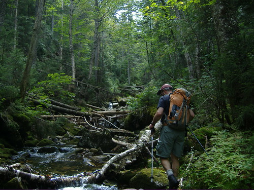
I did follow remnants of trail/logging road for portion of way to the falls area, but after that nothing.
 
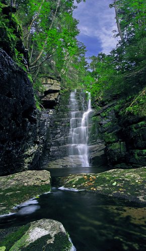
I've been to Hawthorne Falls about 6 times now - it's a frequent side-trip while working on the Gale River trail. First up, Hawthorne Falls is about 40 feet tall, not 90... but no less beautiful because of that shorter actual figure. There is an old path/herd path that is easy to follow for a quarter-mile off-trail to a big rock slab and waterfall. Beer bottles at this location show it is not very "hidden". From there, it is a good trek of a bit under 2 miles uphill to Hawthorne. The terrain is rugged, and the method of least resistance is to head straight up the brook bed. Of course, during high water when the falls are the best looking, this becomes more difficult.

The biggest charm that I find from Hawthorne Falls is the multitude of beautiful cascades on the way up. Some nice ledges along that route.

384974_2590432403178_753227851_n.jpg
 
That's a beautiful pic, NeoAkela, thank you for sharing it. Do you find the trip to be onerous, as has been suggested, or more in the tough-but-manageable range? Do you go there-and-back from the Gale River trail, or do you continue on up to the GRT? And do you mind being asked about your time frames on the trip? Have you done it in wet weather and dry? Have I reached 20 questions yet? :D
 
Last edited:
I'd call it "tough but manageable", but everyone's opinions on off-trail excursions differ. Not bad at all on a warm day during a long dry spell, but fairly impassible during icy early spring runoff. I was turned back one snowy February day, and one wet day in May. I've never come down from the ridge as I'd heard it was rather rough (as Jazzbo confirmed); always up and back from the GRT. I've been meaning to someday go up GRT and loop down via the Hawthorne ravine, but haven't done it yet.

Trip time is quicker with the relocation of the trail - it cuts out a bit of the bushwhack. Going at a good pace on a good day, I can reach the falls in about 2 hours, but it's usually a bit longer. I've tried bushwhacking on both sides of the bank... both have their share of open woods and steep, thick, blowdown infested terrain. No matter which side you walk, you often are forced back down to the brook. Perhaps approaching from high above and not dropping down until you are parallel to the falls would be easier, but I haven't tried that yet. There are some ledgy, cliffy bits on both sides high up, so that might be an issue if dropping down from further up.
 
I am very interested in this bushwhack and will surely attempt it sometime in June. I have been doing a-lot of research on posts on the subject and reviewed a bunch of old maps online. I printed it all out and put it in a folder for safe keeping till the spring. I think I will order a 1/24,000 map of Franconia area to look closer at the stream locations and general terrain and contours for the area. Thanks all for the great information.
 
My experience mirrors NeoAkela & Jazzbo's. It's manageable to get to the Falls, though patches of thicker stuff lurk about. At the beginning your hopes may rise as there are bits and pieces of old path. They quickly fade. From the rock slab/waterfall we stuck to the brook for a good ways before heading up the left bank and into the woods somewhere around here:
5008684927_69c74d605a.jpg


You have to be somewhat careful not to overshoot the Falls. We came down back to the brook just above and crossed over to the right bank and descended through some of the nastiness Jazzbo mentions. From the Falls to the ridge is definitely tougher--after several sessions of therapy I can now vaguely recall walking on balance-beam blowdowns, the ground unseeable, while simultaneously pushing through dense new growth--but the reward is putting yourself in prime position to bag some 3,000 footers.
 
Last edited:
Nice photo, TEO. Thanks for more input. I think Sunshine Chris's approach is sensible - get lots of good data and plan thoroughly. An engaging project to take on. Come to think of it, might be good to take this on in late October, with leaves down but with minimal cold-weather impact, picking the right day for that, of course.
 
I had planned to go there this year but never made it. Found it on Google Earth. Had not heard of it prior.

From G. E.
29173787.jpg
 

Attachments

  • 29173787.jpg
    29173787.jpg
    54.3 KB
Cool! That's another of my photos than Dean Goss put on Google Earth. From my 2009 trip:

http://www.vftt.org/forums/showthread.php?32093-Hawthorne-Falls-Success-09-02-09

This thread inspired me a bit, so when a co-worker asked about going on a small hike somewhere today, I picked Gale River and Hawthorne falls. The bushwhack to the big rock slab was fairly easy... afterward, we used microspikes to follow the brook up. For the most part, it was decent going. The slabs were thick with ice, but most were manageable. Where it got too steep, we crunched up through the trees. By the time we got to Hawthorne itself, we had broken through a few times and were soaked up to the knees, but it was a warm 30 degrees with no wind, so it wasn't bad. The ice allowed me to walk right up to the base of the falls, which is impossible in the summertime. Really impressive! Started at 10 AM, Falls by 1 PM, back to the car at 3:15. Lots of stops for photos on the way.

533501_4950403600983_748847778_n.jpg
 
Last edited:
Cool! That's another of my photos than Dean Goss put on Google Earth. From my 2009 trip:

http://www.vftt.org/forums/showthread.php?32093-Hawthorne-Falls-Success-09-02-09

This thread inspired me a bit, so when a co-worker asked about going on a small hike somewhere today, I picked Gale River and Hawthorne falls. The bushwhack to the big rock slab was fairly easy... afterward, we used microspikes to follow the brook up. For the most part, it was decent going. The slabs were thick with ice, but most were manageable. Where it got too steep, we crunched up through the trees. By the time we got to Hawthorne itself, we had broken through a few times and were soaked up to the knees, but it was a warm 30 degrees with no wind, so it wasn't bad. The ice allowed me to walk right up to the base of the falls, which is impossible in the summertime. Really impressive! Started at 10 AM, Falls by 1 PM, back to the car at 3:15. Lots of stops for photos on the way.

That is awesome! I have some similar photos of Race Brook Falls in Sheffield, MA. B/c of data switchovers, I don't know if I still have them locally, but they are here in my Panoramia stream and on the next page: http://www.panoramio.com/user/5078936?comment_page=1&photo_page=70. That romp in the snow was one of my favorite days hiking yet - I love frozen waterfalls and pics of them. I may just give the Galehead/Hawthorne Falls in winter thing a go. Thank you, NeoAir.
 
Thanks for the inspiration, JustJoe. I've put them on my to-do list. I've often listened to them from the new trail, but have not yet seem them.
 
Top