help on old road to summit of Killington

vftt.org

Help Support vftt.org:

This site may earn a commission from merchant affiliate links, including eBay, Amazon, and others.

Jason Berard

Well-known member
Joined
Oct 28, 2006
Messages
1,321
Reaction score
212
Location
N. Thetford, VT Avatar: Cabot, winter 2011
I wondering if anyone has been on this this trail/road up Killington. It seems to be sandwiched between the Bucklin trail, and the trail/road that is further south, and heads more towards Little Killington and Mendon. I was thinking it might make part of a nice loop over Killington and Mendon. If anyone has any helpful info, they could PM me if they don't want to post the info here. Thanks!
 
The lower part of this old road is clearly the old carriage road that is now part of the Catamount Trail as well as being the traditional route up to Mendon. However, it does leave that route near this junctionand heads up much more directly than even the northern branch seen on the recent topo maps.

I'm not sure of anything following that line these days, though I'll bet if there is, it's a ski trail in the winter.

The top of this old road appears to line right up with the LT/AT/spur junction at Cooper Lodge, so one could try to follow it top-down or bottom-up.
 
Jason Berard said:
I wondering if anyone has been on this this trail/road up Killington. It seems to be sandwiched between the Bucklin trail, and the trail/road that is further south, and heads more towards Little Killington and Mendon. I was thinking it might make part of a nice loop over Killington and Mendon. If anyone has any helpful info, they could PM me if they don't want to post the info here. Thanks!
The Buclin Trail follows an old road in its lower miles. It may be the same. I've been all the way up the Mendon Road and the Buclin Trail and I have seen no sign of anything else. There's an old route of the AT that you can find remnants of down hill from Cooper Lodge.

The trees and ground cover grow fast in that area. I couldn't even find the old AT route along the ridge from Killington to Pico and I searched through the forest around Rams Head for some time.

Your Road seems to follow the ridge line whereas Buclin and Mendon both go up drainages (almost). It even ends at a little black square which might be Cooper Lodge. Have fun. Bring an emergency radio locator :D
 
thanks guys. I do agree that its the same as the Catamount Trail at the bottom.I tried to find a more recent topo map that still had this road on it, but could only find the most recent one which doesn't show the road, and the one the link points to which is from 1893. It seems like it might be fun to try and follow.....with the trails on either side, there would be bail out options if it was too dense, or simply no longer there. I wonder if this road was used to haul materials up to construct Cooper Lodge...
 
Last edited:
Cooper was built in 1939, so if that's the case then that road was there a long time prior, and a building there as well.
 
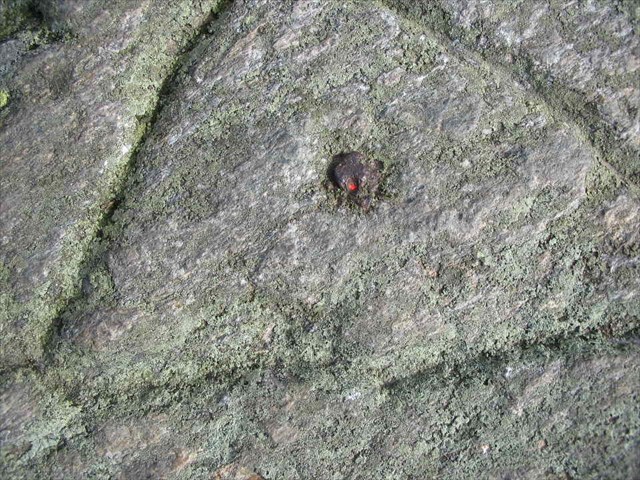
I was on Killington last week and with a surveyor friend we recovered the summit survey mark (an iron bolt within a chiseled triangle). I reported the recovery to the NGS and noticed this on the datasheet:

OD1332 STATION RECOVERY (1897)
OD1332
OD1332'RECOVERY NOTE BY COAST AND GEODETIC SURVEY 1897 (ATM)
OD1332'THE BOLT AND TRIANGLE MARKING STATION AND WITNESS MARKS
OD1332'OF 1879, WERE RECOVERED.
OD1332'
OD1332'TO REACH KILLINGTON PEAK FROM RUTLAND, TAKE STAGE 14 MILES
OD1332'TO KILLINGTON PEAK HOTEL, WHICH IS ONLY 300 FEET BELOW THE
OD1332'STATION.
OD1332
OD1332 STATION RECOVERY (1907)
OD1332
OD1332'RECOVERY NOTE BY COAST AND GEODETIC SURVEY 1907 (WHB)
OD1332'HOTEL ON KILLINGTON IS ABANDONED. FAIR ROAD FROM RUTLAND
OD1332'TO FOOT OF PEAK. STEEP AND ROUGH ROAD FROM HOTEL TO SUMMIT
OD1332'ROCK.
OD1332
OD1332 STATION RECOVERY (1935)
OD1332
OD1332'RECOVERY NOTE BY VERMONT GEODETIC SURVEY 1935
OD1332
OD1332'A STONE HUT IS ON THE W SIDE ABOUT 1/8 MILE BELOW
OD1332'THE TOP, BUT THE KILLINGTON PEAK HOTEL NO LONGER EXISTS.
So this tells me the black dot may have been the old Hotel which was abandoned by 1907 and gone by 1935. It also says Cooper Lodge may have been there by 1935, if that is the stone hut referred to.

For those interested, this is the station mark:

178edaed-3e28-4957-9494-7e5aabb10314.jpg


Next time you're up there, look for it. The red dot is from the "laser plumb" from my friend's surveyor's equipment. Here's my log for that recover on the Geocaching site: Killington Log

Funny how disparate things come together.
 
Last edited:
Some arduous Googling revealed:
By 1859 newspapers printed accounts of people hiking to Killington’s top. A year later, a simple cabin was constructed below the summit for summer usage. Soon a carriage road stretched to the crest and visitation continued to increase, necessitating better facilities. To meet this need, the Killington House opened in 1880 a hundred yards below the peak.
Changes in transportation technology started a decline in business and by 1910, the landmark closed, eventually succumbing to weather, vandalism and fire.
Another site says
Coopers Cabin (sic), on the Long Trail stands on this same spot today.
So there ya go!
 
Late last month, I hiked to Killington from Shrewsbury Peak. So I was on the Long Trail from south of Little Killington to Cooper Lodge.

I was looking for the top of that carriage road since that was the way I'd come up once before after visiting Mendon. It is a lot more noticeable than I remembered and there was a small cairn on the side of the LT at the top of it. I did not notice anything else that looked remotely trailish or old roadish any where else before that and I was looking since I wasn't sure how far it was, having never been on that section before. It did look like the carriage road might have continued further uphill past the LT once upon a time.

So if this trail that you're looking for isn't the carriage road continuation you'll have to be better than me at spotting old trails (which might not that hard to be :D )
 
Cool MJ! Did you see the entry from Oscar wilde in the guest book!?

I sent an email to the GMC and got a response back the same day! :cool: :eek: It seems there are references to this road in Forest and Crag, and a book called Green Mountain Adventures by Will and Jane Curtis, which I gather is an account of James P. Taylor and the early days of the Long Trail.
 
Last edited:
SteveHiker said:
Late last month, I hiked to Killington from Shrewsbury Peak. So I was on the Long Trail from south of Little Killington to Cooper Lodge.

I was looking for the top of that carriage road since that was the way I'd come up once before after visiting Mendon. It is a lot more noticeable than I remembered and there was a small cairn on the side of the LT at the top of it. I did not notice anything else that looked remotely trailish or old roadish any where else before that and I was looking since I wasn't sure how far it was, having never been on that section before. It did look like the carriage road might have continued further uphill past the LT once upon a time.

So if this trail that you're looking for isn't the carriage road continuation you'll have to be better than me at spotting old trails (which might not that hard to be :D )
HI Steve. I think what you saw is the top of the Mendon road. If you whack Mendon from the usual route, you go up the road and make 3 (I think) crossings of the stream then do the whack (search for trip reports to Mendon. Here's mine). Then if you return to the road from Mendon to where you started the whack, and keep going up the road, it will deteriorate into a single track and eventually you'll get to the place you described. I rebuilt that cairn a while back and I know there are others who did also. Jason's road is further north and evidently went right up to where Cooper Lodge is. There's a bunch of stuff there like cross country ski trails, the top of the Buclin Trail and an old unused part of the AT. Hopefully if folks find it they'll report back here.

Shrewsbury is a nice peak isn't it? Did you see that leanto a little ways off the trail. And the old chimney near the trail head. I love those old abandoned things.
 
Last edited:
I got this reply from the GMC last night:
Following the old carriage road up might be difficult, though less so than if the trees hadn't mostly lost their leaves. I last did it maybe eight years ago. It's perfectly clear till the main traveled road begins to descend to cross the brook. That's the first descent I can think of since the trailhead at Brewers Corners. At that point, ascend left instead. Last time I did it, the next quarter mile or so was choked with blackberry bushes up to six feet tall. There are also several left turns, and it's hard to tell which is correct. If you miss the road, you can always just follow the ridge uphill and range back and forth across it till you find the old road. Leave plenty of time, because the top half mile is not only deeply eroded but also probably blocked with fallen trees. The old hotel site is about level with and perhaps 60' east of the Cooper Lodge spring. With all the leaves off, you may be able to discern the outline of the foundation and find a few bricks still. Also at the same level, farther east, is the top end of the wide old Juggernaut Trail. Good luck, and let me know what you find if you go.

So the first chance I get in November.....thats where I'm headed! :D
 
Juggernaut? That doesn't seem right.

Take a look at this Google Map view. It's centered on the summit. The small rectangle to the northwest is Cooper Lodge. What I believe is the Juggernaut Trail heads from the south side of the summit off the bottom of the map, a long distance from the lodge, and aren't there two possible springs, one north of the Lodge, one west down the Bucklin Trail, neither anywhere near Juggernaut?

Speaking of Cooper Lodge:
Name: Little Killington Shelter Construction
Description: Construct new Killington Shelter on LT/AT to replace Cooper Lodge Shelter.
Scoping Date: 2008
Decision Date: 2008
Status: Project delayed and under review.
Ref
 
MichaelJ said:
Juggernaut? That doesn't seem right.

Take a look at this Google Map view. It's centered on the summit. The small rectangle to the northwest is Cooper Lodge. What I believe is the Juggernaut Trail heads from the south side of the summit off the bottom of the map, a long distance from the lodge, and aren't there two possible springs, one north of the Lodge, one west down the Bucklin Trail, neither anywhere near Juggernaut?
Hmmm

I'm not sure of the xc trail names but there is a huge sign down hill from Cooper Lodge where the Buclin trail comes up that tells skiers not to go down that way (apparently it has happened) so something goes over that way. Also if you zoom in your Google maps aerial view another click you can see the outline of some trail going from the top corner of the xc trail that heads along the ridge to Pico going down to Cooper Lodge.
 
Ayup, this sign. But that's alongside Great Northern after coming down from the Gondola, across the tops of Rime and Reason.

I think this is the location that everyone means, but that calling it Juggernaut is wrong.
 
Top