AHIKER
New member
On 8/12/15 I left my car at Lincoln Woods visitors center and took the AMC shuttle to Zealand Trail head. At 12:45 I started hking south on "Z" trail to Ethan Pond Trail
then started down Thoreau Falls Trail. After having looked at the photos on this web site one would have thought that the Thoreau Falls trail was a railroad bed where
it was like hiking through a tunnel!! Big surprise. Only the lst 1/3 of the south end of the trail was like that. Anyway, I originally thought I would stop at the "soon to be removed" bridge
over the East branch of the Pemi but when I got there (about 9.5 miles) I decided to try to make it to the campsites on the East Side Trail. So, I continued south on the
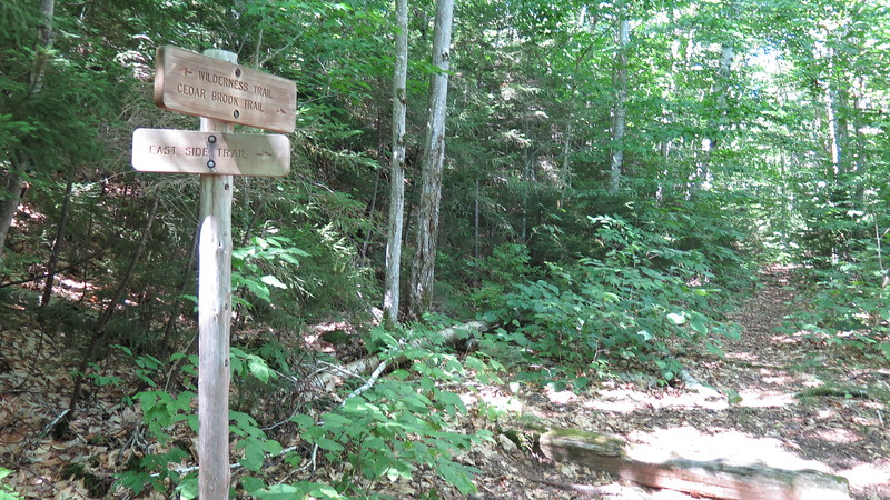
Wilderness trail till I reached the Cedar Brook Trail that goes over towards the Hancocks. My map ("White Mountains waterproof Trail MAp from MAp Adventures) shows
the East Side Trail meeting at this junction. It also shows the East Side Trail going south and heading a very short distance over to the East Branch of the Pemi and continuing
south along the river. So, I walked down to the river and that is where it all went wrong!!! NO EAST SIDE TRAIL to be found. I spent a long time searching. I did find a short
trail going south a few hundred feet to a fire ring but no east side trail!!! By this time I was totally exhausted and started bushwacking along the river. At one point I walked
away from the river uphill further into the woods and still no trail!!! No place to pitch tent either!!! Finally after about .2 miles I saw a sand bar (mostly baseball sized rocks)
on the river and realized that I had to stop there. I spent the night there concerned with what I as going to do the next day. Finally, I looked at the map again and considered
the old Bond Cliff trail which I was familiar with and realized that my best alternative was to ford the river and bushwack up to the Bond Cliff Trail. The ford wasn't too bad at
only 3 feet or so at deepest part. The bush wack was something else though. downed trees and logs everywhere. I'd be 4' off the ground on a tree one minute and trying
to fight my way through the deep brush the next! Fortunately I KNEW that the trail was up there and finally reached it. All I could think of as all this was going on was
that if anything happened to me that they would NEVER find my body!!! Once I got on the Bond Cliff trail it was a 5 mile easy walk back to Lincoln Woods.
So, my RANT is that if they are going to have trails marked on maps and included in the guide books they should make sure that they can be found and what happened to
me should not happen to anyone else in the future.
I am 76 years old and in pretty good shape for my age but I was certainly taxed to the limits of my endurance on this one. You might ask why I did not simply return
back the way I came. Well, that was an option but I could not have made it the "Z" trailhead for the 9:20am shuttle back to Lincoln woods.
Finally, we all know that HINDSIGHT is always 20/20 and I do expect that there will be folks reading this that will offer suggestions on what I should have done or not done.
The reality, however, is that when the boots are on the ground, we are very tired and frustrated we do not always do what may seem obvious to those who have not been in
this situation.
I do welcome suggestions on what might be done to bring attention to the right people about the location of that trail at its north end? I still cannot figure out why I could not find it??
In case anyone is interested and thinks that this is just a "City Dweller" who got in over his head, I want you to know that I have been a long distance hiker since 1968 and have hiked the whole
AT, 200 plus miles of the Colorado Trail and the Long Trail 2 times as well as all the 4000 footers in New England and some in NY. This is to say that I can find my way around in the woods
and in the 45 some years I have only gotten confused once and that was when I turned left rather than right on the AT after leaving a lean-to just south of Bear Mountain in NY!!! I remember it to
this day!! Other than that I have always been able to find and stay on the trail and never needed a compass (I had one on this trip as well as a small air horn and whistle).
One last word. I have decided that at my age it is just to dangerous for me to hike solo on a trip like this so will stay on more busy trails in the future. Thanks to all for letting me share this
experience with you.
Happy Trails from Rindge, NH
Gordon "Renaissance Man" Ripley
Last edited:


![Grand Teton Day Hikes and National Park Map [Map Pack Bundle] (National Geographic Trails Illustrated Map)](https://m.media-amazon.com/images/I/41DB0jvRnbL._SL500_.jpg)


![Yellowstone National Park [Map Pack Bundle] (National Geographic Trails Illustrated Map)](https://m.media-amazon.com/images/I/51kGuJ72qjL._SL500_.jpg)


![Grand Canyon, North and South Rims [Grand Canyon National Park] (National Geographic Trails Illustrated Map)](https://m.media-amazon.com/images/I/419Y-ycyVUL._SL500_.jpg)

