SpencerVT
Member
My wife and I crashed at the Blue Ridge Motel Friday night intending to hike Weyman Mountain Saturday. This hotel was inexpensive and decent enough, but it was seriously like walking into a time capsule. All of a sudden we were back in 1964, which is the year everything in the hotel seemed to be from. I kept looking around to see if the Supremes were playing live or something!
Anyhow, we saw that the weather was going to be a huge departure from the intense humidity we've been having lately and only be around 73 degrees and overcast. So we decided to change plans on head for McDonnel mountain instead.
McDonnel is one of the most remote, hostile and difficult peaks in all of the Adirondacks. There is no easy straight forward way to get there. Renee and I headed up the Allen Brook herd trail and then got off at 3700' to whack around the cusp of Allen and cut over to the slopes of McDonnel.
The weather was perfect and the flies weren't too bad. Whacking around the cusp of Allen was steep and pretty thick. Once we got around the cusp the terrain pushed us downward towards the basin between Allen and Redfield aka, what I like to now call "no man's land."
The basin area between Allen and Redfield is an apocalyptic nightmare of hurricane-like devastation. It was like the aftermath of a tornado,
only with rainforest thickness re-growth. Most of the time, I had no idea what I was walking on. I could not see the ground. it was just a chaotic disarray of blowdown, logs, stumps, branches, rocks and God knows what else. Logs were constantly breaking beneath me causing me to fall. It was treacherous and slow going. It took us like 2 hours to travel 1/2 mile. When we arrived at the base of McDonnel where it starts to gain elevation again, the forest mercifully opened up and became fairly open matchstick forest all the way to just below the very summit of McDonnel - not bad at all! And we made good time heading up. The very summit of McDonnel had tons of blowdown, which made finding the highest point difficult. There was absolutely no sign of humanity anywhere or having ever been there. I wonder how many people have ever climbed this peak? By all evidence it seems extremely seldom visited.
We decided instead of going back over the steep cusp of Allen to the Allen herd trail, that was would head down to the skylight brook and then take the brook back to where it would eventually meet the trail. Boy was this a mistake. The area between Allen and Redfield all the way down almost to the skylight brook was a snarled rainforest-thick conifer-hell obstacle course that chewed us up, and eventually after another 2 hours, spit us out on the skylight brook. I was so sweaty and dirty that I jumped into the skylight brook and went for a swim, which was super cold and felt amazing.
A LONG day and a very tough bushwhack, but I was happy to visit such a remote barely visited Adirondack peak.
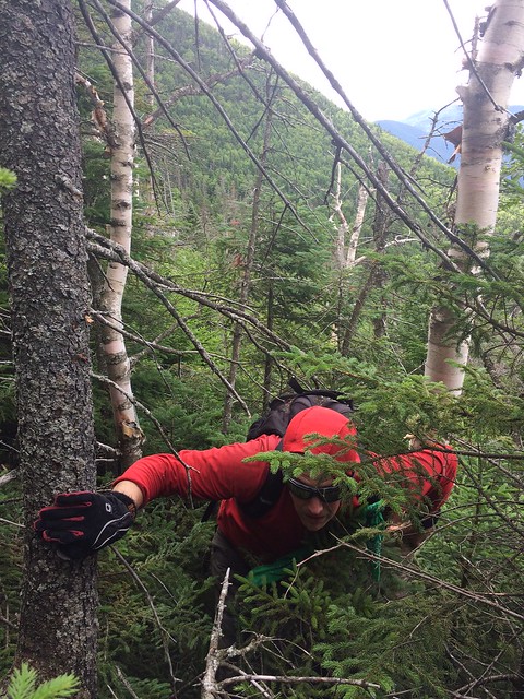
Me bushwhacking around the steep cusp of Allen on the way to McDonnel
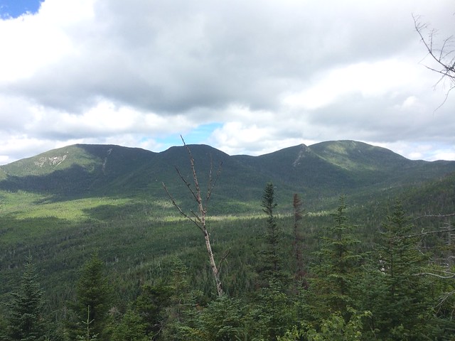
View towards Redfield and Skylight from side of Allen.
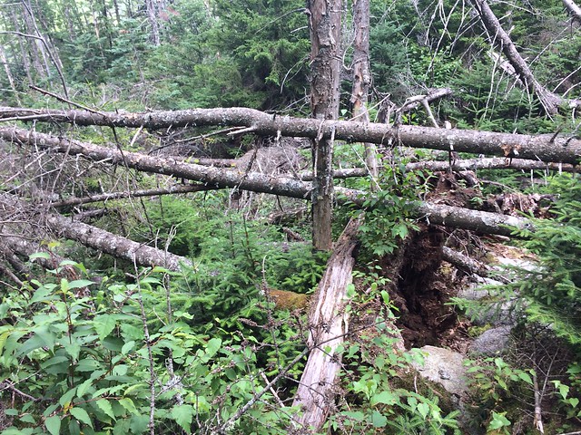
This basin area between Allen and Redfield will shred your clothes!!
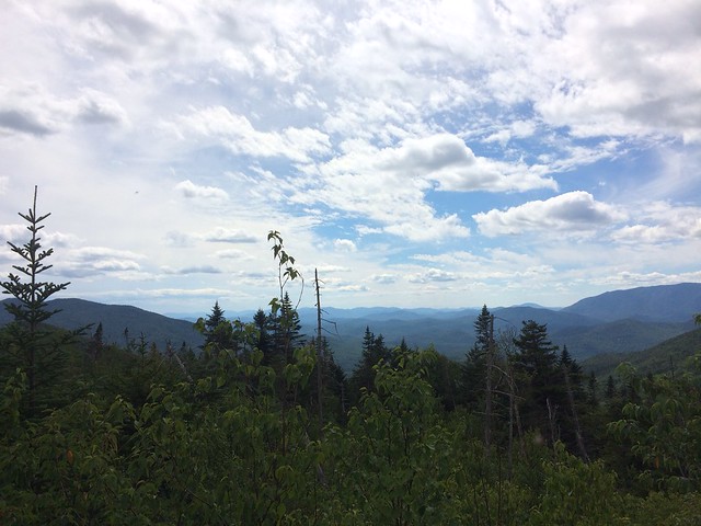
Great view coming off McDonnel looking south.
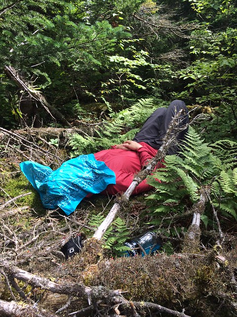
My wife resting at the summit of McDonnel no doubt thinking to herself "what in the hell was that?!!" in reference to the conifer blowdown mayhem of the forest route we took to get to McDonnel.
Anyhow, we saw that the weather was going to be a huge departure from the intense humidity we've been having lately and only be around 73 degrees and overcast. So we decided to change plans on head for McDonnel mountain instead.
McDonnel is one of the most remote, hostile and difficult peaks in all of the Adirondacks. There is no easy straight forward way to get there. Renee and I headed up the Allen Brook herd trail and then got off at 3700' to whack around the cusp of Allen and cut over to the slopes of McDonnel.
The weather was perfect and the flies weren't too bad. Whacking around the cusp of Allen was steep and pretty thick. Once we got around the cusp the terrain pushed us downward towards the basin between Allen and Redfield aka, what I like to now call "no man's land."
The basin area between Allen and Redfield is an apocalyptic nightmare of hurricane-like devastation. It was like the aftermath of a tornado,
only with rainforest thickness re-growth. Most of the time, I had no idea what I was walking on. I could not see the ground. it was just a chaotic disarray of blowdown, logs, stumps, branches, rocks and God knows what else. Logs were constantly breaking beneath me causing me to fall. It was treacherous and slow going. It took us like 2 hours to travel 1/2 mile. When we arrived at the base of McDonnel where it starts to gain elevation again, the forest mercifully opened up and became fairly open matchstick forest all the way to just below the very summit of McDonnel - not bad at all! And we made good time heading up. The very summit of McDonnel had tons of blowdown, which made finding the highest point difficult. There was absolutely no sign of humanity anywhere or having ever been there. I wonder how many people have ever climbed this peak? By all evidence it seems extremely seldom visited.
We decided instead of going back over the steep cusp of Allen to the Allen herd trail, that was would head down to the skylight brook and then take the brook back to where it would eventually meet the trail. Boy was this a mistake. The area between Allen and Redfield all the way down almost to the skylight brook was a snarled rainforest-thick conifer-hell obstacle course that chewed us up, and eventually after another 2 hours, spit us out on the skylight brook. I was so sweaty and dirty that I jumped into the skylight brook and went for a swim, which was super cold and felt amazing.
A LONG day and a very tough bushwhack, but I was happy to visit such a remote barely visited Adirondack peak.

Me bushwhacking around the steep cusp of Allen on the way to McDonnel

View towards Redfield and Skylight from side of Allen.

This basin area between Allen and Redfield will shred your clothes!!

Great view coming off McDonnel looking south.

My wife resting at the summit of McDonnel no doubt thinking to herself "what in the hell was that?!!" in reference to the conifer blowdown mayhem of the forest route we took to get to McDonnel.
Last edited:

