Well, it was time for a return to Seattle to make sure Doug was still in good climbing shape. Lucky for me, he had a plan already in place before I even got there. I had been wanting to get on the North Face of Mt. Hood for some time, but this year it was not in the cards for May with the large snowfall the mountains received. Even luckier for me, the Cascades are a spectacular Plan B.
A mudslide had occurred about a month back and closed off a portion of the road that led to the trailhead access road, so we added mountain bikes to our gear list before departing Seattle at 6 a.m. We drove as far as we could, parked and walked up the now, dry mudslide to the other end. Then it was time for some pedalling. The slide had added about 4 miles to our approach. 1 mile on paved road and the rest on the dirt forest road. Biking with a pack filled up climbing gear was a sure interesting and exhausting way to start the trip!


Once at the trailhead, we had a 6 or 7 mile hike into the Stuart Range and where we'd be camping for the night. The summit was in the clouds that evening, but the weather was decent and tomorrow's forecast was promising bluebird.

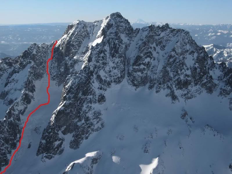
We camped down a small enbankment in some great smelling pine trees and away from the wind. We were at about 5,400' so we knew there was a big day ahead of us and turned in early. We woke up a bit later then we wanted to (by about 3 hours) so we decided on the Ice Cliff Glacier route. It was less technical and maybe a bit shorter in length. The sun was rising as we ate a quick meal, packed up and headed out. The forecast was spot on and we were greeted with warm temps and sunshine.

Once we were up and over the old glacial moraine and terminus from years ago, we reached the start of the glacier, as it is now, and I was impressed at the ice cliffs signalling its start.

We climbed to the left of the cliffs up some steep snow and wound our way around some crevasses and other beautiful glacial features.


Once over the micro-bergshrund, we were dumped in front of a steep snow couloir with very large cornices guarding its top. The temperatures were getting too warm and we were aware of the possibility of those cornices to come down. There was constant reminder of this from the never-ending flurry of ice and snow pellets raining down the couloir. We travelled solo and light to ascend quickly.


We found a good spot to top out and it was an incredible moment as I climbed up on the summit ridge. There wasn't much that needed to be said there and not much I can write here, but it was so much fun and I am still smiling from it.

We had some great views, as Mt. Stuart is the highest mountain in the range, as well as one of the highest in the Cascades. Mt. Rainier, Mt. Adams and Glacier Peak could be seen as well as hundreds of jagged peaks.

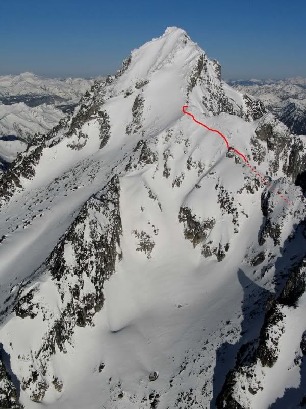
When we started up towards the summit, we began to get concerned about the potential for avalanche activity. Add to the warmth making the snow sticky and slippery at the same time, we decided it was best to head down. Going one at a time, we traversed across and down the summit ridge to our descent route on the Sherpa Glacier.

The Sherpa Glacier was steep once we reached it and we had to down climb it for what seemed like hours.. but finally the glacier relented a bit and we were able to walk down to camp. We climbed a total of 3,300-3,500 feet to the summit ridge and back down the same in about 7 hours. So we reached the tent at 1 p.m., hung around and relaxed and then headed out. Once at the mountain bikes, it was an awesome 4 miles of cruising downhill and we reached the car by 7 p.m. and then it was over to Leavenworth for some german food and, of course, beers.
There's some more photos, both mine and Dougs, HERE
The next day we did some rock climbing out in the desert in Vantage. It was gorgeous and awesome to spend the day in an entirely different environment. Photos are HERE
A mudslide had occurred about a month back and closed off a portion of the road that led to the trailhead access road, so we added mountain bikes to our gear list before departing Seattle at 6 a.m. We drove as far as we could, parked and walked up the now, dry mudslide to the other end. Then it was time for some pedalling. The slide had added about 4 miles to our approach. 1 mile on paved road and the rest on the dirt forest road. Biking with a pack filled up climbing gear was a sure interesting and exhausting way to start the trip!


Once at the trailhead, we had a 6 or 7 mile hike into the Stuart Range and where we'd be camping for the night. The summit was in the clouds that evening, but the weather was decent and tomorrow's forecast was promising bluebird.

At the base of the mountain, scoping out a tentsite.
We camped down a small enbankment in some great smelling pine trees and away from the wind. We were at about 5,400' so we knew there was a big day ahead of us and turned in early. We woke up a bit later then we wanted to (by about 3 hours) so we decided on the Ice Cliff Glacier route. It was less technical and maybe a bit shorter in length. The sun was rising as we ate a quick meal, packed up and headed out. The forecast was spot on and we were greeted with warm temps and sunshine.

Once we were up and over the old glacial moraine and terminus from years ago, we reached the start of the glacier, as it is now, and I was impressed at the ice cliffs signalling its start.

We climbed to the left of the cliffs up some steep snow and wound our way around some crevasses and other beautiful glacial features.


Once over the micro-bergshrund, we were dumped in front of a steep snow couloir with very large cornices guarding its top. The temperatures were getting too warm and we were aware of the possibility of those cornices to come down. There was constant reminder of this from the never-ending flurry of ice and snow pellets raining down the couloir. We travelled solo and light to ascend quickly.


Approaching the steep couloir and looking back at our tracks.
We found a good spot to top out and it was an incredible moment as I climbed up on the summit ridge. There wasn't much that needed to be said there and not much I can write here, but it was so much fun and I am still smiling from it.

We had some great views, as Mt. Stuart is the highest mountain in the range, as well as one of the highest in the Cascades. Mt. Rainier, Mt. Adams and Glacier Peak could be seen as well as hundreds of jagged peaks.

Mt. Rainier (right) and Mt. Adams (left).
When we started up towards the summit, we began to get concerned about the potential for avalanche activity. Add to the warmth making the snow sticky and slippery at the same time, we decided it was best to head down. Going one at a time, we traversed across and down the summit ridge to our descent route on the Sherpa Glacier.

The Sherpa Glacier was steep once we reached it and we had to down climb it for what seemed like hours.. but finally the glacier relented a bit and we were able to walk down to camp. We climbed a total of 3,300-3,500 feet to the summit ridge and back down the same in about 7 hours. So we reached the tent at 1 p.m., hung around and relaxed and then headed out. Once at the mountain bikes, it was an awesome 4 miles of cruising downhill and we reached the car by 7 p.m. and then it was over to Leavenworth for some german food and, of course, beers.
There's some more photos, both mine and Dougs, HERE
The next day we did some rock climbing out in the desert in Vantage. It was gorgeous and awesome to spend the day in an entirely different environment. Photos are HERE
Last edited:


