una_dogger
Well-known member
Stats:
Mt Tremont 3371, gain 2600'
Mt Tremont Trail, out and back: 5.6 miles
Y Alpine, 74/100
Finally got around to hiking Mt Tremont today, after having it on my bucket list for about two years now! Taking it nice and easy and the use of hiking poles made this a comfortable hike and we were in and out in five hours, with plenty of time for pictures and a very leisurely summit break.
The Mt Tremont trail enters the woods on the south side of Rt 302 and begins by following a gentle old logging road. Within a short walk, it reaches a beautiful babbling brook that it follows for some time. The brook travels through a deep ravine, and pristine hemlock and beech forests frame either side. There are many cascades and flumes. This is a very special trail and I was very glad we chose to hike here today.
At the top of the ravine, the trail crosses the brook, and climbs (we counted!) 28 switchbacks to the summit of Tremont. The trail is narrow, well maintained, and very easy under foot; soft and mossy with ivy and clintonia growing right up to its sides. I don't think Mt Tremont sees much traffic, and we only saw three others today. At one point, the trail seems to cross the rubble of an old slide. There is also the remains of an extensive blow down area on the climb. Limited views of the Presidentials and the Davis Path can be seen along this section.
The grade steepens significantly for the final ~ third mile to the summit. The forest here is very mossy, and its reminiscent of Mt Nancy just down the road a stretch. I saw a wood toad hop across the trail near the summit and wondered "how the heck did he/she get up here?". Nature is always inspiring.
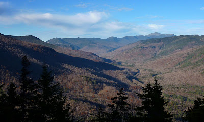
When we reached the summit, we were rewarded with *amazing* views into the Sawyer River Wilderness and the surrounding mountains, from Chocorua to the far East, Square Ledge, Passaconnaway, Whiteface with its northern slide in the Downs Brook Valley clearly visible from this angle, across the Tripyramids, Oseolas, twisty bits of the Kancamangus, the Hitchcocks, Hancocks, Carrigan, Vose Spur, an amazing perspective of Carrigain Notch. In the foreground, Green Cliff stands like an island within the expansive Sawyer River Wilderness with its many ponds and moose wallows. A truly White Mountain Wilderness Experience and one of the finer views I've enjoyed in some time. I can imagine what it must have been like back in the day when the Sawyer River Rd and Livermore Rd were a more prominent feature of this landscape.
A trip to Owl Cliff and across the Sawyer River Wilderness is definatley in my plans for my return visit to Mt Tremont. The trail off the backside of Tremont drops a staggering 800 feet to Owl Cliff, and from where we stood, it looked straight down.
I highly recommend this hike. The woods, the flumes, cascades and brook, the hemlock forest, the well constructed switchbacks, the mossy upper reaches of the trail, and the amazing views make Tremont a new favorite of mine. And Terra concludes that its very dog friendly, with many streams for drinking and pools for dipping.
A short detour east on 302 took us to the perfect summer apres hike refreshment, iced coffee and a cider slushee from the White Mntn Cider Company in Bartlett. Two thumbs up!!!
A few choice pics:
Cascades

Footpath

Mossy

Peaceful

Nearing the top

Us

Carrigain Notch

Green Cliff Drama

More Summit Drama

Dipper

Mt Tremont 3371, gain 2600'
Mt Tremont Trail, out and back: 5.6 miles
Y Alpine, 74/100
Finally got around to hiking Mt Tremont today, after having it on my bucket list for about two years now! Taking it nice and easy and the use of hiking poles made this a comfortable hike and we were in and out in five hours, with plenty of time for pictures and a very leisurely summit break.
The Mt Tremont trail enters the woods on the south side of Rt 302 and begins by following a gentle old logging road. Within a short walk, it reaches a beautiful babbling brook that it follows for some time. The brook travels through a deep ravine, and pristine hemlock and beech forests frame either side. There are many cascades and flumes. This is a very special trail and I was very glad we chose to hike here today.
At the top of the ravine, the trail crosses the brook, and climbs (we counted!) 28 switchbacks to the summit of Tremont. The trail is narrow, well maintained, and very easy under foot; soft and mossy with ivy and clintonia growing right up to its sides. I don't think Mt Tremont sees much traffic, and we only saw three others today. At one point, the trail seems to cross the rubble of an old slide. There is also the remains of an extensive blow down area on the climb. Limited views of the Presidentials and the Davis Path can be seen along this section.
The grade steepens significantly for the final ~ third mile to the summit. The forest here is very mossy, and its reminiscent of Mt Nancy just down the road a stretch. I saw a wood toad hop across the trail near the summit and wondered "how the heck did he/she get up here?". Nature is always inspiring.
When we reached the summit, we were rewarded with *amazing* views into the Sawyer River Wilderness and the surrounding mountains, from Chocorua to the far East, Square Ledge, Passaconnaway, Whiteface with its northern slide in the Downs Brook Valley clearly visible from this angle, across the Tripyramids, Oseolas, twisty bits of the Kancamangus, the Hitchcocks, Hancocks, Carrigan, Vose Spur, an amazing perspective of Carrigain Notch. In the foreground, Green Cliff stands like an island within the expansive Sawyer River Wilderness with its many ponds and moose wallows. A truly White Mountain Wilderness Experience and one of the finer views I've enjoyed in some time. I can imagine what it must have been like back in the day when the Sawyer River Rd and Livermore Rd were a more prominent feature of this landscape.
A trip to Owl Cliff and across the Sawyer River Wilderness is definatley in my plans for my return visit to Mt Tremont. The trail off the backside of Tremont drops a staggering 800 feet to Owl Cliff, and from where we stood, it looked straight down.
I highly recommend this hike. The woods, the flumes, cascades and brook, the hemlock forest, the well constructed switchbacks, the mossy upper reaches of the trail, and the amazing views make Tremont a new favorite of mine. And Terra concludes that its very dog friendly, with many streams for drinking and pools for dipping.
A short detour east on 302 took us to the perfect summer apres hike refreshment, iced coffee and a cider slushee from the White Mntn Cider Company in Bartlett. Two thumbs up!!!
A few choice pics:
Cascades
Footpath
Mossy
Peaceful
Nearing the top
Us
Carrigain Notch
Green Cliff Drama
More Summit Drama
Dipper
")


![Yellowstone National Park [Map Pack Bundle] (National Geographic Trails Illustrated Map)](https://m.media-amazon.com/images/I/51kGuJ72qjL._SL500_.jpg)


![Grand Canyon, North and South Rims [Grand Canyon National Park] (National Geographic Trails Illustrated Map)](https://m.media-amazon.com/images/I/419Y-ycyVUL._SL500_.jpg)


![Grand Teton Day Hikes and National Park Map [Map Pack Bundle] (National Geographic Trails Illustrated Map)](https://m.media-amazon.com/images/I/41DB0jvRnbL._SL500_.jpg)