New Hampshire Stone Wall Project

vftt.org

Help Support vftt.org:

This site may earn a commission from merchant affiliate links, including eBay, Amazon, and others.
If you're just looking for LiDAR "imagery", go to Granit View, then:

Click on View Layers
Check the Elevation box
Check the Regional Elevation box
Check the Regional LiDAR box
Choose the Hillshade or Shaded Relief boxes
 
Salty

I was wondering what happened to the Swipe feature so I contacted someone who informed me Stone Wall Mapper site has been moved to NH DES server and will be managed by them in future. He responded as follows:

We moved the stone wall mapper to a different organization today, sorry you missed the notification. But if you update your link to this: https://nhdes.maps.arcgis.com/apps/webappviewer/index.html?id=f4d57ec1a6b8414190ca0662456dffb0 it should not require any sign-in.

Granite View still has LIDAR, but not Stone Wall Mapper.

FYI I inquired about the Swipe feature and how I wished I could swipe back and forth between Topo and LIDAR he responded as follows:

In regards to the the split screen, I'm not sure I know to what you are referring. Is it the Swipe Widget? If yes, then it is an ArcGIS Online tool that we have enabled for the Stone Wall Mapper and may not be available in other LiDAR viewers. For example, swiping is not available in our GRANITView mapper because it is based on different software.

As a result of the site migration yesterday, we are no longer the group who maintains it. That chore has transferred to the NH Department of Environmental Services. But the USA Topo service should be visible to you, as long as the map scale is not too large (i.e. zoomed in, the maximum view scale is 1:18,056). Most map services have zoom scales and once a defined scale is exceeded, the image no longer shows. I am able to view the USA Topo layer and swipe the hillshade (the topo is not swipeable because it is a base layer).
 
Last edited:
Ooooo. This makes me so happy. Thanks for the new link. I find it to be a great hiking research tool.
 
I inquired with my contact at UNH an additional question of interest to explorers of WMNF

Sorry to bother you again. Is there any plans to LiDAR White Mt National Forest region? LiDAR data would provide many benefits to users of the national forest. I explore area around Tripoli Road and noticed LiDAR cuts off south of Mount Osceola ridge line. I was able to verify I my GPS track indeed followed part of route of old road to former fire tower on Mount Osceola and could detect possible route it took. LiDAR shows old skidder roads which could be re-purposed as hiking trails. LiDAR could also be valuable to Search and Rescue operations.

To which DJ responded

Yes, that area has been acquired and will become available sometime in the near future. We are awaiting the data from the USGS (the government shutdown delayed things a lot). Maybe we will have it in the late spring (although it was supposed to be delivered last December...).
 
There is a series of articles in today's Conway Daily Sun about stone walls and the "sheep boom". https://bloximages.newyork1.vip.tow...-11e7-97a4-6be1adaf4869/5cccba26ac269.pdf.pdf. Definitely worth checking it out.

One of the articles on page 4 states the missing block in Eastern NH from Conway to Berlin is accessible as of this week.

I just went on the stone wall project and this area is still missing but perhaps someone with more experience with the site can find it.
 
Last edited:
I was on Stonewall Mapper last night and LIDAR imagery wasn't available. I think they must be working on the database. I profited from recently from mapper in that I was able to find logging road beforehand in area I was visiting. I went off in direction and sure enough there was the old road and I knew where it would end up. I was looking for cellar holes of abandoned farms up around Guinea Hill in Sandwich. I failed to find them on the ground but after uploading my GPS track I was able to see how I missed them and now can go back and know right where to find them. Pretty cool stuff!!!
 
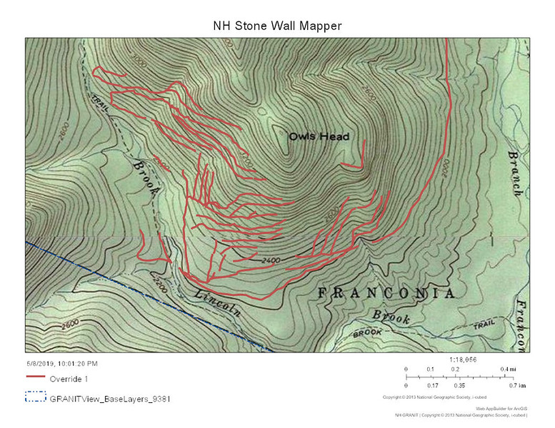
White Mt National Forest is now in Stone Wall Mapper. I played around with it last night. I was right about another time suck hole. JR Henry's logging RR and skidder trails show up quite nicely. although NE and NW shading seem to have some limitations. I was studying areas around Owlshead and Franconia Brook. Here is a sample. Too bad one can't save one's work somehow. it is kind of a pain to do all that work and then have it disappear. I managed to trace out skidder trails and change map layer to topographic and produce a JPG of topo map with traced trails. Very extensive skidder trail networks.

Owls%20Head%20Topo%20South%20skidders-L.jpg
 
Works for me now thru the stone wall mapper, doesn't seem to work directly through granit.

Definitely a time suck but a potentially major resource for off trail navigation.
 
Thank you Jazzbo for catching this so soon after the release! No time suck for me (at the moment), I'm at work and it's lunchtime. :) I went looking around some spots I've been to previously as well as locations I've been wanting to look into, and I'm ecstatic at what I'm seeing. Besides the RR beds, it's pretty obvious (at least where I'm looking) what the main haul roads were. I'm assuming the data through GRANIT won't be too far behind, I'm pretty excited to get a hold of the raw georeferenced data.
 
Wanna see something neat? On the satellite view (not lidar) there is a ghostly image of a jetliner and its contrails just north of the bridge at the south end of the Rocky Branch Trail!
 
Looks like the state is now fully covered with lidar DEM, with the basemap at https://granitview.unh.edu/html5viewer/index.html?viewer=granit_view , but this does not show at http://lidar.unh.edu/map/ .
So, good news, and I'll have to update my bookmark.

I misspoke...at that site,"statewide hillshade" is statewide complete (and very useful). But "regional hillshade" and "regional shaded relief" is statewide incomplete, and the regional "digital elevation" is also incomplete, blurry and not useful.
 
I misspoke...at that site,"statewide hillshade" is statewide complete (and very useful). But "regional hillshade" and "regional shaded relief" is statewide incomplete, and the regional "digital elevation" is also incomplete, blurry and not useful.

Seems to be some confusion about who is hosting the site. Management of site was transferred to NHDES - not UNH which I think is associated with GRANIT. Of course text on website refers to GRANIT which I suppose is UNH, but actual site is now hosted by NH DES. One problem with Stonewalls Mapper is no way to record other features of landscape i.e. skidder trails and RR beds which are as much of historical artifact as are the stonewalls. All are relics of today's landscape built by hard working people who struggled to survive by blood sweat and tears and made NH what it is today.
 
This time for real:

Database Update: Umbagog LIDAR collection
Date/Time(s): May 23, 2019
Event Type: GRANIT News
URL: http://lidar.unh.edu
The long-awaited Umbagog LIDAR data is now available. Please visit the GRANIT LiDAR data distribution site (see URL above) for more information.
 
I was able to confirm Larry Garland's number of 3995' for Tecumseh (not doubting Larry by any stretch, just checking that my methods aren't mussed up), and Guyot indeed lacks the prominence at the Bond col. Trying to find time to check some other things (Sandwich Dome, Lincoln prominence and S. Hancock prominence).
 
And then there were 46...

First off, I screwed up the Guyot calculation. It's goofy looking terrain, and I must have picked the wrong col.

So here's the data for what I was interested in. This is basically searching elevation data with a mouse, so I wouldn't call it definitive, but I'm guessing (unless I picked a wrong spot) to be accurate within a foot.

Tecumseh: 3994.6'

Bondcliff: 4262.8'
Bondcliff-Bond col: 4042.7'
Prominence: 220.1'

West Bond: 4517.5
West Bond-Bond col: 4301.8
Prominence: 215.7'

south Guyot: 4564.1'
north Guyot: 4581.4'
Guyot-Bond col: 4344.4'
Guyot-S. Twin col: 4361.9'
Prominence: 219.5'

Sandwich: 3960.6'

Lincoln: 5078.5'
Lincoln-Lafayette col: 4899.5'
Prominence: 179'

south S. Hancock: 4257.4'
north S. Hancock: 4246.6'
S. Hancock-N. Hancock col 4078.3'
Prominence: 179.1'

Soooo, add Guyot, remove Tecumseh, and as most have suspected/known for some time, also remove Lincoln and S. Hancock.

If you want to be accurate and such. :)
 
Top