Old White Mountain Map! (1882)

vftt.org

Help Support vftt.org:

This site may earn a commission from merchant affiliate links, including eBay, Amazon, and others.

Jason Berard

Well-known member
Joined
Oct 28, 2006
Messages
1,321
Reaction score
212
Location
N. Thetford, VT Avatar: Cabot, winter 2011
A friend of mine was given a copy of Pickering's "Walking Guide to the Mt. Washington Range" which is a pretty cool read! A friend of his picked it up at a yard sale for 50 cents! :eek: :cool:

Anyway, here are a couple pics of the maps....

2507629600099656796S600x600Q85.jpg


2734906480099656796S600x600Q85.jpg


2576928990099656796S600x600Q85.jpg


I'll post some passages from the book a little later on, but I thought you'd all like to see this. Some of the names are different.....and Pickering notes the declination as 13 degrees.....

full album here
 
I'll pay him $5 right now for it. :D Come on he can't beat that with a stick. That's a hell of a profit.

Man what a score. I love old maps.

Lucky guy. I'm green with envy.

Keith
 
Jason Berard said:
Pickering notes the declination as 13 degrees.....
Magnetic declination does change over time, as the north magnetic pole moves. 13 degrees over a century ago wouldn't surprise me.
 
I knew that, but that seemed like a big swing to me.....
I imagine he knew what he was doing, though....

There are some interesting points of interest in the legend....

Henry Hunter's monument....Lizzie Bourne's monument......Mike's house....

I'm gonna enjoy studying this for a while before I give it back. :)

Steve Smith told me that this is the one White Mountain Guide Book he doesn't have....I guess its quite rare.
 
Last edited:
I like the line that represents the Upper Boundary of High Scrub and Trees. Jason, what are the boundaries N,S,E, &W, are they roads, trails, or anything else? That I can't tell from the map.
Thanks for posting!
 
jniehof said:
Magnetic declination does change over time, as the north magnetic pole moves
we stopped by the Ranger Station before climbing Mount Baker in WA a few years ago, looking for decent maps of the Easton Glacier approach

while we were there, Doug asked the Ranger what the local magnetic declination was

the Ranger paused, then told us that she'd call someone to "determine what today's declination is"

we looked at each other, wondering if the Ranger knew what magnetic declination is ?

after a few phone calls, one where the Ranger said, "well, find out what it means, because we have people waiting here" ... she finally walked over and admitted that she did not know what declination was

we explained it ... then she asked how often magnetic declination changes ... we figured not much more than a couple degress over 100 years ?
 
Last edited:
I once found this great "private" collection of old 1700s and up maps of north america, many of new england. Anybody knows what I'm talking about ? It required you to install some software but I don't remember what the website is :mad:
 
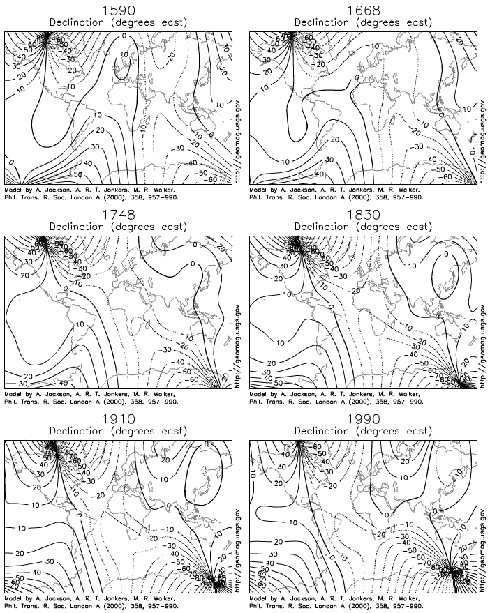
Awesome model Marc! It changes alot more than I would have expected.

Arm, That's too funny (and sad) that someone in a ranger station did not know about declination. You would think they would remember it a little from high school, even grade school let alone any special training they get!
 
Anyone know where you can buy such a map, for decorative purposes? Doesn't have to be an original. I'd love to frame a White Mt. map....
 
marchowes said:

Definitely preety kool Marc. It's interesting if you watch the 0 degree line over the Atlantic during the period fro 1600 to 1700. Very rapid change in contrast to the next 200 yesrs. Did Colunmbus have a compass; because if he did it's amazing he did not go in circles.
 
Dave Bear said:
too funny (and sad) that someone in a ranger station did not know about declination
it's surprising how many people who work in National Parks and outdoors areas rarely hike or explore the amazing places they spend their lives in

you ask them for advice on checking out fun outdoors stuff, and many times you get the same answer, "Sorry, I don't know, I've only been working here for 35 years."

it was a rare treat to meet an elderly Ranger in Glacier National Park years ago, who worked in the reservations office ... he spoke with such enthusiasm when he talked about each area visitors would ask him about, as if each trail, peak, waterfall, scenic area, was the best thing that ever happened to him

BSP is one park where Rangers actually get out and explore the park ... Rob Tice gave us good advice on anchors (that he planted on ice climbing routes near Chimney Pond) we could rap off ... Brendan could talk your ear off about bushwhacking near Russell Pond (drawing maps with trees for landmarks) or off-the-beaten-track ice routes near South Branch Pond ... most folks who work in BSP work there for life (in more ways than one)
.
 
As promised, here are a few passages from the book....

"Advice to Pedestrians:"

"None of the walks described below should be attempted except by a good pedestrian, as distances upon the mountains are very deceptive in appearance. Walking alone is to be discouraged, not only on account of the danger spraining an ankle upon the loose stones, but also in case of a cloud suddenly settling down on the mountain: a person alone is more liable to loose his direction than if he has companions."

'.... a gossamer rubber coat is very useful in case of a sudden shower, if one is above tree-line, or in a good path."

"The commonest ills that the pedestrian is heir to are sunburn and blisters.
The former may be cured by rubbing the parts affected with milk,if it is applied in time. The best remedy for the latter is to put on a piece of sticking plaster. In more serious cases, a piece of wash-leather with a hole in it may be tied on. Often merely rubbing the sock thoroughly with soap at the point of contact will remedy the difficulty."


"In summer the temperature it midday on the summit may be anywhere from 35 degrees to 70 degrees, and the wind from zero up to seventy miles an hour. And the conditions of the temperature and the wind make a far greater difference in one's enjoyment of an alpine walk than the novice would at first suppose. The man who walks over the Crawford Path, or the Great Range, with the thermometer at 40 degrees, and the wind blowing from twenty to thirty miles an hour, has not the least idea of the enjoyment of him who takes the same walk when the thermometer is at 60 to 70 degrees, and when there is not a breath of air stirring. It is then, and then only, when high above tree-line, with one or perhaps two companions, that the grandeur and loneliness of the great peaks really break on him; then for the first time does he begin to understand their marvellous attractions."


I'll post more later....maybe something from one of the recommended trips.....
 
Top