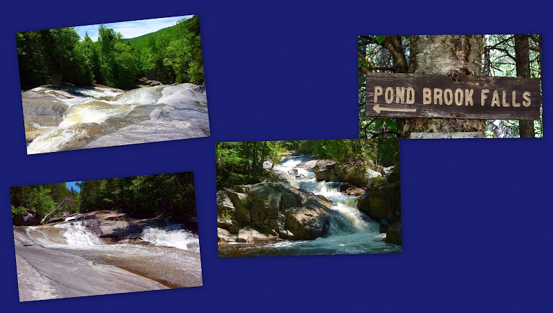
Percy Peaks and Pond Brook Falls (04-Jun-2011)

vftt.org

Help Support vftt.org:

This site may earn a commission from merchant affiliate links, including eBay, Amazon, and others.

1HappyHiker

Well-known member
Joined
Jan 18, 2007
Messages
1,973
Reaction score
405
Location
Bethlehem, NH
Sometimes I even outdo myself in terms of getting a late start that is well beyond the 'crack of noon'. This past Saturday (04-June) was one of those days! Anyway, with what was left of the afternoon, I opted to drive up north to the Nash Stream Forest and see what I could do in a few hours. I had in mind to visit at least one of the Percys (North or South), and maybe both depending upon how things went. Before embarking on a Percy pursuit, I also wanted to stop by Pond Brook Falls since that was a spot I'd never visited.

Below are two of the several snapshots that were taken during this trek. If you might be interested in reading more about this trek and/or seeing more photos, then please click HERE to access my Blog.

Percy Peaks
P1020712.JPG

Pond Brook Falls
PondBrkFalls.jpg
 
I've been told about a gazillion times over the past few years that I have to visit pond brook falls, as many rate it their favorite falls in the whites. And your pictures certainly support that!
 
Nice!

Now, I'm off to read the details. Thanks for the link.

:)
 
Nash Stream is an very interesting place that really doesnt get a lot of use considering the clamor that occurred when the former Diamond Occidental Forests lands were being sold off. Arguably the auction of the lands gave the final push for the Northern Forest Initiative to get funded.

The Nash stream area had been purchased prior to the auction, allegedly via a back room deal, by a real estate developer with ties to then Govenor Sununo. The conservation community became aware of some of the plans which included stripping the area of gravel, and eventually the state of NH bought the parcel from the developer. Unfortunately despite being purchased by NH as state lands to protect the area, the decision was made to prevent overnight camping in the area. This prohibition has remained in effect, although there may have been an exception for a campsite on the Coos trail which runs through the area. Also included in the original deal was that the private camps in the area would be "sunsetted" after a period of time. Recently with little public notice, the leases have been extended indefinitely. Given the very remote location and the lack of any public facilities it has limited visits to a really interesting area.

If someone is interested in the area, about the closest state campground is Milan Hill State Park. The WMNF South pond campground used to be closer, but it is now only open for day use. A general issue to note is the Millsfield windfarm project is just to the east and it is expected that the transport of the wind turbines could impact access to the area via RT 3 at some point.
 
Last edited:
Great blog and pics John. Those cascades look very inviting on a hot day. The Percy peaks have a bit of a Bald-Face look to them....

Petch
 
Really good info given by peakbagger and also in addition to the Percys, Sugarloaf has a very excellent view...and Nash Stream is really not too far from the Twin Mt area,or Jefferson, or Lancaster, with motels and campgrounds..Groveton has a couple of motels too on Rt. 3..you would enjoy it!!
 
I've been told about a gazillion times over the past few years that I have to visit pond brook falls, as many rate it their favorite falls in the whites. And your pictures certainly support that!
Jim, make that a gazillion and one! You really should make a visit to Pond Brook Falls!:)

Nice! Now, I'm off to read the details. Thanks for the link.
Thanks Earl for the comment here, and on my Blog!
Nash Stream is an very interesting place, that really doesnt get a lot of use considering the clamor that occurred when the former Diamond Occidental Forests lands were being sold off. Arguably the auction of the lands gave the final push for the Northern Forest Initiative to get funded.

The Nash stream area had been purchased prior to the auction, allegedly via a back room deal, by a real estate developer with ties to then Govenor Sununo. The conservation community became aware of some of the plans which included stripping the area of gravel, and eventually the state of NH bought the parcel from the developer. Unfortunately, despite being purchased by NH as state lands to protect the area, the decision was made to prevent overnight camping in the area. This prohibition has remained in effect, although there may have been an exception for a campsite on the Coos trail which runs through the area. Also included in the original deal was that the private camps in the area would be "sunsetted" after a period of time. Recently with little public notice, the leases have been extended indefinitely. Given the very remote location, the lack of any public facilities, it has limited visits to a really interesting area.

If someone is interested in the area, about the closest state campground is Milan Hill State Park. The WMNF south pond campground used to be closer but it is now only open for day use. A general issue to note is the Millsfield windfarm project is just to the east and it is expected that the transport of the wind turbines could impact access to the area via RT 3 at some point.
Wow Peakbagger! Thanks so much for taking time to post such interesting info on the Nash Stream area! Very much appreciated!

Great blog and pics John. Those cascades look very inviting on a hot day. The Percy peaks have a bit of a Bald-Face look to them....Petch
You're right!! I never made that connection! The Percys and the Baldfaces do have a somewhat similar look.

Really good info given by peakbagger and also in addition to the Percys, Sugarloaf has a very excellent view...and Nash Stream is really not too far from the Twin Mt area,or Jefferson, or Lancaster, with motels and campgrounds..Groveton has a couple of motels too on Rt. 3..you would enjoy it!!
Thanks Lefty! You're so right about the fact that the Nash Stream area is actually not that far from places where a lot of folks stay overnight and camp, like in the Twin Mountain area, Jefferson area, etc. From Bethlehem, it takes me only about 45 minutes to drive to trailheads in the Nash Stream area and the Kilkenny region.
 
Last edited:
John

A couple weeks ago heavy rains washed out a number of roads in the state forest and over the ridge at Stratford Bog. Like many significant weather events in the NH North Country, very little news information made it south. The sole news report I heard referenced most of the drama up the road towards Trio Ponds and past- I assume this would have all washed down to affect the road by Pond Brook Falls, thus the road conditions you discovered. Interesting thing is that a major ice dam happened at the culvert for Pond Brook on Nash Stream Rd. late this winter, and when it let go it scoured out the road just south of the culvert for quite a distance. I was there the next day in a grooming tractor and was blown away by how much force came down that little brook, and even more blown away when I heard that the boys had the snowmachine trail along the road reopened in just a day or 2 with the damage I saw. I have some impressive pictures but find posting to this site overly tedious. I wonder if the road conditions were a combination of early spring road repairs from the winter washout and more impact/repairs from the rains of the past few weeks.

I agree about the falls, Lindsay and I stumbled upon them last autumn but did so on an old abandoned interpretive trail just up the road from the trailhead you used. Really cool since there was a sense of adventure trying to follow the almost imperceptible trail, and the 3" thick moss on the bog bridge planking. I was blown away when we got to the falls and put them at the top of my list. I'm amazed by so many N. Country falls that are so much more impressive than many world renowned ones in the tourist hotspots to the south and on the way to notable peaks (anyone ever heard Giant Falls?). Did you see that huge old Cedar near the top of the falls that was being held up by a younger tree? I was worried that that winter washout finally took it out.

A new assignment this winter sent me all over the Nash Stream forest, and I must agree that this is one special piece of heaven. I can't beleive some of the cool places I cruised through and wildlife I observed, deciding that I could forget about the Whites for a while (won't happen), and stumble about this property for a while. If you get a chance, try to visit Canberry Bog Notch by travelling (north) from the north end on of the Nash Stream Rd. Full of the subtle beauty that I and you both seem to enjoy.
 
A couple weeks ago heavy rains washed out a number of roads in the state forest and over the ridge at Stratford Bog. Like many significant weather events in the NH North Country, very little news information made it south. The sole news report I heard referenced most of the drama up the road towards Trio Ponds and past- I assume this would have all washed down to affect the road by Pond Brook Falls, thus the road conditions you discovered . . .
Hmmm! Sounds like this could be a definite contributing factor to the road conditions I encountered.
Speaking of the Nash Stream Road, would you have a suggestion for a website (or someone to contact) regarding opening/closing of this road in the Spring and late Autumn?:confused:
A new assignment this winter sent me all over the Nash Stream forest, and I must agree that this is one special piece of heaven. I can't beleive some of the cool places I cruised through and wildlife I observed . . .
Yup! I agree 100%. The Nash Stream Forest (and the North Country in general) is for sure a "special piece of heaven"!
If you get a chance, try to visit Canberry Bog Notch by travelling (north) from the north end on of the Nash Stream Rd. Full of the subtle beauty that I and you both seem to enjoy.
Thank you for the suggestion!! It's been added to the list!:)
 
John

Try the North Region HQ for NH Forest & Lands, 788-4157. Who ever answers should know the road status, if not ask for Maggie Machinist the Region Forester, of John Accardi the Ranger Captain.
 
John

Try the North Region HQ for NH Forest & Lands, 788-4157. Who ever answers should know the road status, if not ask for Maggie Machinist the Region Forester, of John Accardi the Ranger Captain.
Thanks Andrew for that info about who to contact regarding the open/closed status of Nash Stream Road . . . much appreciated!
Dang! I sometimes forget about what a great resource those folks are at NH Forest & Lands, not only for roads, but for many other things relative to forest land outside the WMNF boundaries.
 
Top