Recommendations For My 2nd GPS Unit - Anything New The Past Few Years?

vftt.org

Help Support vftt.org:

This site may earn a commission from merchant affiliate links, including eBay, Amazon, and others.
So tell me why I can have the 60CSX continuously display the GPS compass for as much as 24 hours on one set of batteries?
I have no inside information about the implementation of the compass rose display.

However to hazard a guess:
* Computation consumes power
* The display only needs to be updated a few times a second. One would normally insert power-conserving waits in the loop updating the display to avoid an excessive update rate.
* The Guess: they may have inserted inadequate wait time in the loop in the 62s.

While the above guess is plausible, there is no guarantee that it is correct. The implementation could be power-hungry for other reasons.


FWIW, I have implemented software real-time compass rose displays (in a software flight simulator). The entire simulator (with 2 compass rose displays) has sufficient waits that it only consumes a small percentage of the cpu time. (Which would reduce the power consumption in a battery-operated device.)


EDIT: here is the raw data:
Code:
                                ma    
                 ----------------------------------              
                  60CSx #1     60CSx #2       62s    
                 ---------    ---------    --------             
GPS normal       110           75           85     
magnetic sensor  110(+0)       75(+0)       85(+0)
rose display     110(+0)       75(+0)      170(+85)
light 100%       260(+150)    205(+130)    180(+95)
60CSx #1=older 60CSx
60CSx #2=newer 60CSx
GPS norm=normal operation, light off, no magnetic sensor or rose display.

BTW, A 7-hour battery life would suggest a current drain of ~285ma (=~2000mAh/7h) which is similar to the measured draw of the 62s with everything on (~265ma). (The typical capacity of an AA cell is 2000--2500 mAh.)

Doug
 
Last edited:
Ha! Perhaps there's a market for a scissors-like stylus! Until then though, I'm without pinch/stretch until I figure out a good way to attach styli to my glove fingertips or take my glove off. After I set it up upon initiating my hike, GAIA is usually able to meet all my needs sans pinch/stretch.

Alex

Good to know. I may find that I don't need the pinch/stretch once I've used Gaia a little more.
 
I just use an iphone with Google Maps, but I don't use it to navigate unless I am truly lost. I usually come out of the woods with 90% battery left on my phone because I barely touch it while I'm hiking, and if I need it to stretch for a few days I just put it in airplane mode and turn off location services. Really the only risk is keeping it dry, but I have a little clear submersible drybag for it, so it's covered. (Pun intended!) Google Maps lets you download maps ahead of time, and set a waypoint for where you've parked your car. That's really the only information I need to stay alive, especially in the northeast. haha
 
Our combo is : peakbagger for reference, caltopo for prints when Delorme atlas is not enough, 64s (got it on sale to replace the 60csx) and Gaia app for overview / logging roads navigation.
 
I had a 60CSX and loved it. It however is somewhere around 2800' near Jumping Brook in the Pemi Wilderness. My GF has an Oregon 450. I'd really like the touch screen. Bought a $500 62(don't remember the letters) and hated it. You had to be moving to get your heading. Started using the GF's Oregon 450 and ended up loving it. Got my own off ebay and have been using it since. I'm not tech wiz but I believe this is what make it better than the 62 I bought... built-in 3-axis compass with barometric altimeter. You can get your heading while standing still. And as far as the touch screen, I've never had an issue, not even on the coldest of days. The touch is not the same tech. as smart phones, it's pressure sensitive. It works with any kind of glove. Can't speak for the new gen Oregon's. But I use an ultra-lite glove under mittens (which are leashed) in winter, so I just slip a mitten off if I need to. And from the get-go I've been using energizer rechargeables. I rarely have to change batteries.

I dreading the day mine ***** the bed.
 
Being a Master USCG licensed Captain,commercial Fisherman and using Loran C early on then to the first commerical GPS units (Northstar 941D) for mariners I transferred this knowledge for my hiking. Garmin was way behind the tech back then but rocketed skyward. I wish I bought stock in Garmin. After many years of hand held hiking GPS use since 1998 and I have the tracks from every hike since..not matter how small of a hike. Great data hindsight.

I now run the Montana 680T. Amazing unit. Best unit I've ever owned. Run's all day long while hiking with plenty of left over battery life on the OEM installed battery. A good set of Black Panasonics will take it further as well. This is due to it's menu and options of shutting down battery drain but still recording,etc. I don't use the compass on it. With the Glonass and Waas it's the most accurate receiver I've ever owned. I have a small case on my shoulder strap it sits in all day and doesn't miss a beat (every second) in the mountains and under snow laden tree cover.

Wife has a Oregon 700T which is nice ( has Glonass and Waas) but too small for me. It only weights a few ounces less. Not worth the compact size for my old eye. The only bad thing is touch screens.. in the severe cold..well below zero a keypad type might be better for those in that element. I've used this 680T in 11 below and other temps hovering around 0 deg F with no issues on my hikes. It does sit in a padded case and being it's running since the trail head thru the whole hike (even lunch etc) it probably keeps warm enough for a no issue use.

The 680 is a top product still for Garmin and hard to find used or on sale. I now have two of them. One dedicated for my snowmachines that log near 1500 to 2000 miles per season. One dedicated for hiking. Two Garmin 61 S Drive Smart dedicated for the Truck used for business accounts across New England,hauling my truck camper,personal use. Garmin makes a top product.

On a side note with coordinates sent via email from a friend it put me right on the rock on Mt.Washington Ethan Allen Crawford carved E A C 1820 this past week. Won't leave home without it.
 
Last edited:
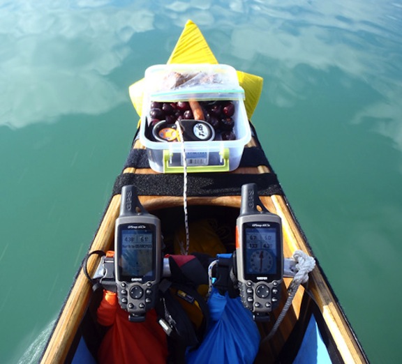
I've always been very happy with my Garmin 60csx for many years. I detest that I later bought a 62. I hate the change in the display interface appearance and the way it mounts to handlebars and canoe thwarts, requiring use of zip cable ties each time you change where it mounts. The 60 requires only a stubby phillips screwdriver that I carry in my PFD to go from one canoe to another. And the 60 will always last for more than 24 continuous hours on one set of batteries. I can practically set my watch with batteries dying in the 62 every 7 hours, almost exactly 7 hours every time, regardless of display or settings, while the 60 continues to happily purr on. I use 2 60csx units with different info displays in front of me, mounted to the thwart of my canoe during canoe races, but I almost threw the dang 62 in the Yukon river after the 3rd battery set died on the 7 hour clock during a Yukon River race. I had the 62 running only as a backup with another crew member and did not change screens or manipulate it at all during operation until the 7 hour dead battery mark. I always use lithium batteries in all GPS units. My SAR team has the newer 64 model, which I have shown during search incidents acts the same as the unfortunate 62 with dislikable display screen and poor battery life. So I went to ebay and bought 2 additional 60csx units while I still could.

Consider setting the display to North Up only, or switch to a screen that does not display a map...perhaps de-select terrain or noaa charts and simply have the base map on the screen. The power necessary for the CPU to do computations to decide what objects should be included on the map, display the map, rotate the map, and update the map is huge compared to simply updating some digits in the trip computer screen.

Check the manual for other power saving features such as display illumination time or intensity, disabling the compass, pressure, and temperature sensors. And turn off unnecessary communication such as Bluetooth or nmea serial output, or ANT for interfacing to other sensors

I think that initial or default settings are designed to give a user an operating mode which gives an impressive feature set without forcing the user to read the manual or figure out any menus. This has nothing to do with maximizing battery life.

I have never had a GPS that produced a reading which was inconsistent from my compass.

However, there are far too many things that can go wrong when using the GPS compass.

-Failure to re-calibrate when batteries are changed
-Inaccurate calibration by having large tilt or rotating fast, but not enough tilt or rotation to trigger an error screen.
-Failure to hold the unit perfectly level when calibrating...some people recommend that you rest the unit on a flat, non-magnetic surface when you twist it for calibration.
-Calibration with a significant magnetic disturbance being applied-- the metal of a heavy watch or the magnets in many of fitness watches.
-Erroneous interpretation of indication as magnetic north/true north

Some mitigations include

-excessive tilt warning during use
-showing the sun and moon on the compass dial to serve as a quick check.
-prompting to check unit for consistency after time or distance has increased by a certain amount
-blanking compass screen after battery change without a calibration
-blanking the compass screen when the unit is being operated outside of its specifications.
-clearly indicating whether a reading is true or magnetic

The technical implementation of most GPS compasses is extremely flawed because most cannot accommodate reasonably foreseeable misuse
 
Last edited:
Being a Master USCG licensed Captain,commercial Fisherman and using Loran C early on then to the first commerical GPS units (Northstar 941D) for mariners I transferred this knowledge for my hiking. Garmin was way behind the tech back then but rocketed skyward. I wish I bought stock in Garmin. After many years of hand held hiking GPS use since 1998 and I have the tracks from every hike since..not matter how small of a hike. Great data hindsight.

I now run the Montana 680T. Amazing unit. Best unit I've ever owned. Run's all day long while hiking with plenty of left over battery life on the OEM installed battery. A good set of Black Panasonics will take it further as well. This is due to it's menu and options of shutting down battery drain but still recording,etc. I don't use the compass on it. With the Glonass and Waas it's the most accurate receiver I've ever owned. I have a small case on my shoulder strap it sits in all day and doesn't miss a beat (every second) in the mountains and under snow laden tree cover.

Wife has a Oregon 700T which is nice ( has Glonass and Waas) but too small for me. It only weights a few ounces less. Not worth the compact size for my old eye. The only bad thing is touch screens.. in the severe cold..well below zero a keypad type might be better for those in that element. I've used this 680T in 11 below and other temps hovering around 0 deg F with no issues on my hikes. It does sit in a padded case and being it's running since the trail head thru the whole hike (even lunch etc) it probably keeps warm enough for a no issue use.

The 680 is a top product still for Garmin and hard to find used or on sale. I now have two of them. One dedicated for my snowmachines that log near 1500 to 2000 miles per season. One dedicated for hiking. Two Garmin 61 S Drive Smart dedicated for the Truck used for business accounts across New England,hauling my truck camper,personal use. Garmin makes a top product.

On a side note with coordinates sent via email from a friend it put me right on the rock on Mt.Washington Ethan Allen Crawford carved E A C 1820 this past week. Won't leave home without it.

Based on your recommendation and some additional research I took the plunge and got a Montana 610 on Amazon (new but it was a lower price than Garmin and the "mainstream" outdoor retailers). Took it for a test drive today and I love it! While the menus are somewhat different than my old GPSMAP62 it basically works the same way so I was able to figure out everything I do on my old unit pretty quickly. I was concerned about getting a touchscreen model but it really is pressure dependent unlike a cell phone as others mentioned and it worked very well. I'm sure even in light gloves it would be no problem.

Only drawbacks: it is a fairly big unit, a bit larger than I realized, so it will be riding in a carry pouch on my hipbelt as opposed to being clipped on with a carabiner. Other drawback is that I didn't get one with maps. It had the World Wide shaded relief map included so I was hoping that would be serviceable but it really is horrible. Nothing more than a high level street map. Have to see what is out there for free downloads. I didn't find the Garmin maps all that accurate to start with.
 
I was concerned about getting a touchscreen model but it really is pressure dependent unlike a cell phone as others mentioned and it worked very well.
We recently scratched the screen of our car gps - it is as good as dead now. I switched to using a smartphone for car driving.
 
Consider setting the display to North Up only, or switch to a screen that does not display a map...perhaps de-select terrain or noaa charts and simply have the base map on the screen. The power necessary for the CPU to do computations to decide what objects should be included on the map, display the map, rotate the map, and update the map is huge compared to simply updating some digits in the trip computer screen.

Check the manual for other power saving features such as display illumination time or intensity, disabling the compass, pressure, and temperature sensors. And turn off unnecessary communication such as Bluetooth or nmea serial output, or ANT for interfacing to other sensors
I come from a past life as a USAF navigator (back when navigators were actually used in aircraft), wherein I used a map (chart) on my desk in front of me with north always being up. That is how I have set the map display on my GPS units as I find it easier to orient the map in my brain to the earth and my direction of travel that way, the same way that I hike with a topo map. I do not use a GPS as a magnetic compass ever, and never will, so I do not calibrate it as a compass. I will always use a real compass when I need to know direction on earth. I do not use the altimeter and do not cycle through that display at all on any GPS.

During the Yukon canoe race I need to have the most detailed maps possible to avoid islands and shoals, so degrading to the base map display is impractical. I have the purchased Garmin edition of the Yukon topo map installed.
LBQgUyu.jpg


All the tips you give do not explain why my Garmin60Csx batteries will last for 24+ hours before I need to replace them, no matter if it is displaying GPS compass, GPS map, or the computation screen. No matter if tracking is on or off, I have tested it both ways in all units. I actually have 4 different 60Csx units (purchased while I could due to frustration with my 62), and all model 60 units are equally reliable and long lasting. But the 62s and 64st models both die at around 7 hours, maybe a little minimally longer for the 64. I use lithium batteries in all units. The backlight is set to turn off within 30 seconds on the 60, the 62 and the 64. I have tried turning off everything that is turnoffable ( tracking etc) on the newer units. However I do not see an option to turn off BT, it only offers send or receive options no way to turn "off" - maybe that is the problem. I came really close to throwing the 62 into the Yukon River during a 1000 mile race due to its frustratingly poor battery performance. I had dual 60s one displaying map and the other on the compass and direction to next waypoint function mounted in front of me in the bow (GPS computed compass, not magnetic mode) while a paddle partner in my boat was trying to use the 62 as my backup. The 60Csx gets turned on well before the race begins and lasts through an entire day and following night, the 62 dies at 7 hours from being turned on after race start. i could set my watch for battery change time.

I first bought the 60Csx because that is the one that was issued to the NYSDEC rangers at the time. Now they have 62s and 64s, but the battery life is not such a time critical problem for them. During a recent SAR incident I even had to show a ranger how to use his 62. If I use a 62 or 64 during a SAR incident, perhaps I can keep ahead of the dead batteries, but that is not realistically possible during a nonstop marathon canoe race.
 
Last edited:
I come from a past life as a USAF navigator (back when navigators were actually used in aircraft), wherein I used a map (chart) on my desk in front of me with north always being up. That is how I have set the map display on my GPS units as I find it easier to orient the map in my brain to the earth and my direction of travel that way, the same way that I hike with a topo map. I do not use a GPS as a magnetic compass ever, and never will, so I do not calibrate it as a compass. I will always use a real compass when I need to know direction on earth. I do not use the altimeter and do not cycle through that display at all on any GPS.

During the Yukon canoe race I need to have the most detailed maps possible to avoid islands and shoals, so degrading to the base map display is impractical. I have the purchased Garmin edition of the Yukon topo map installed.
LBQgUyu.jpg


All the tips you give do not explain why my Garmin60Csx batteries will last for 24+ hours before I need to replace them, no matter if it is displaying GPS compass, GPS map, or the computation screen. No matter if tracking is on or off, I have tested it both ways in all units. I actually have 4 different 60Csx units (purchased while I could due to frustration with my 62), and all model 60 units are equally reliable and long lasting. But the 62s and 64st models both die at around 7 hours, maybe a little minimally longer for the 64. I use lithium batteries in all units. The backlight is set to turn off within 30 seconds on the 60, the 62 and the 64. I have tried turning off everything that is turnoffable ( tracking etc) on the newer units. However I do not see an option to turn off BT, it only offers send or receive options no way to turn "off" - maybe that is the problem. I came really close to throwing the 62 into the Yukon River during a 1000 mile race due to its frustratingly poor battery performance. I had dual 60s one displaying map and the other on the compass and direction to next waypoint function mounted in front of me in the bow (GPS computed compass, not magnetic mode) while a paddle partner in my boat was trying to use the 62 as my backup. The 60Csx gets turned on well before the race begins and lasts through an entire day and following night, the 62 dies at 7 hours from being turned on after race start. i could set my watch for battery change time.

I first bought the 60Csx because that is the one that was issued to the NYSDEC rangers at the time. Now they have 62s and 64s, but the battery life is not such a time critical problem for them. During a recent SAR incident I even had to show a ranger how to use his 62. If I use a 62 or 64 during a SAR incident, perhaps I can keep ahead of the dead batteries, but that is not realistically possible during a nonstop marathon canoe race.

I was not explaining why your older Garmin device lasts longer. I think you will see that info in Doug's post below. I was just giving tips based on my engineering background on how to extend battery life in general.

But, in a nutshell, I suspect that the performance of the 60 unit (resolution, lcd update speed, illumination technology, processor speed (horsepower) , memory width, bit error rate) is inferior to the newer units.
 
Based on your recommendation and some additional research I took the plunge and got a Montana 610 on Amazon (new but it was a lower price than Garmin and the "mainstream" outdoor retailers). Took it for a test drive today and I love it! While the menus are somewhat different than my old GPSMAP62 it basically works the same way so I was able to figure out everything I do on my old unit pretty quickly. I was concerned about getting a touchscreen model but it really is pressure dependent unlike a cell phone as others mentioned and it worked very well. I'm sure even in light gloves it would be no problem.

Only drawbacks: it is a fairly big unit, a bit larger than I realized, so it will be riding in a carry pouch on my hipbelt as opposed to being clipped on with a carabiner. Other drawback is that I didn't get one with maps. It had the World Wide shaded relief map included so I was hoping that would be serviceable but it really is horrible. Nothing more than a high level street map. Have to see what is out there for free downloads. I didn't find the Garmin maps all that accurate to start with.

I have it mounted on my shoulder strap with a Nitze holder.. works well. so does the wife..

Free download maps are hoaky... get the 24 K's from Garmin.. or the 100 k at least.. Fairly big is relative...I think it's just right.. carries well and tracks excellat in my Nitze pouch. and is only a few ounces more. Just did Craig Baldface n and s.. tracked A1 the whole hike.. even with all the rock scrambling backwards,upwards you name it..

I use the magnetic bearings in it with my compass and use it often for our functions during the hike...works A1.. also I love the altimeter and find it's spot on on the summits and shows great ascent decent in the data fields.

I use the track up mostly.. this is the way I used it in my marine life.. following the narrow twisting can't see 10 ft ahead fogged out channels and waterways.
 
Last edited:
Top