
arghman
New member
- Joined
- Sep 1, 2004
- Messages
- 1,352
- Reaction score
- 153
Found a couple of amusing/interesting things in AMC outdoors magazine this month.
One was a Learn to Sail Wknd at Fire Island Cabin, which said:
Read and bring book, "Start Sailing Right" (US Sailing Association). Contact Captain Error! Bookmark not defined., US Sailing Association Certified Instructor, for course info./registration
then there was this ad:
HIKE MAHOOSUCS While your Family recreates with me! Easy day hikes, meals, lodging, shuttles, with registered Maine Guide.
(presumably while you are out suffering on your own )
)
Anyway, the real reason I'm posting is to point out an exhibition on maps that's at Harvard University's Pusey Library (see http://hcl.harvard.edu/info/exhibitions/#maps_white_mtns ) and ends July 31. Unfortunately it is only open on wkdays 9am-4:45pm (the AMC outdoors ad said 9-5pm), which sort of sucks for those of us who work & don't live closeby.
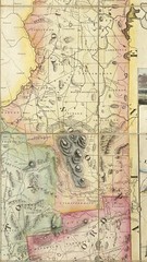
The map exhibition includes the 1816 Carrigain Map of NH. For those of you who haven't seen this before, the Carrigain Map alone would be worth seeing. (I believe it's on display at the NH Historical Society also, which is open on Saturdays) This is a map that was produced by the NH Secretary of State, Philip Carrigain (for whom Mt Carrigain was named) and took over a decade to produce and in the process took a severe toll on Mr Carrigain's vision. It is very detailed and also very large (52"x47"?) and shows all of the towns at the time the map was produced. Copies were given to every NH town, but many were lost. You can look at a copy online at http://www.davidrumsey.com/maps3162.html which has an image browser, here's an excerpt image I downloaded from there. I don't remember whether the original map was in color, this particular instance may have been colored in by whichever town (or private party) owned it.
One was a Learn to Sail Wknd at Fire Island Cabin, which said:
Read and bring book, "Start Sailing Right" (US Sailing Association). Contact Captain Error! Bookmark not defined., US Sailing Association Certified Instructor, for course info./registration
then there was this ad:
HIKE MAHOOSUCS While your Family recreates with me! Easy day hikes, meals, lodging, shuttles, with registered Maine Guide.
(presumably while you are out suffering on your own
)Anyway, the real reason I'm posting is to point out an exhibition on maps that's at Harvard University's Pusey Library (see http://hcl.harvard.edu/info/exhibitions/#maps_white_mtns ) and ends July 31. Unfortunately it is only open on wkdays 9am-4:45pm (the AMC outdoors ad said 9-5pm), which sort of sucks for those of us who work & don't live closeby.
The map exhibition includes the 1816 Carrigain Map of NH. For those of you who haven't seen this before, the Carrigain Map alone would be worth seeing. (I believe it's on display at the NH Historical Society also, which is open on Saturdays) This is a map that was produced by the NH Secretary of State, Philip Carrigain (for whom Mt Carrigain was named) and took over a decade to produce and in the process took a severe toll on Mr Carrigain's vision. It is very detailed and also very large (52"x47"?) and shows all of the towns at the time the map was produced. Copies were given to every NH town, but many were lost. You can look at a copy online at http://www.davidrumsey.com/maps3162.html which has an image browser, here's an excerpt image I downloaded from there. I don't remember whether the original map was in color, this particular instance may have been colored in by whichever town (or private party) owned it.
