Android Hiking App

vftt.org

Help Support vftt.org:

This site may earn a commission from merchant affiliate links, including eBay, Amazon, and others.

Dan J

New member
Joined
Mar 6, 2012
Messages
27
Reaction score
0
Can anyone recommend a good Hiking App for an Android phone? Something that allows me to layout a route and then follow it not requiring cell service. I ran into someone last hike that had an app like I'm talking about. I thought they said it was AnyHiker, but I can't find that anywhere. Any information is appreciated. Thanks.
 
There are many backcountry navigation apps available for Android. I picked six of them and carried out extensive comparative testing.

I recommend Locus Map. When you dig deep into the details, it is the most flexible with a very comprehensive set of features. There's a long post here where I convinced someone to forego buying a purpose-built GPS unit and get a used Android phone with Locus Map. They were very happy with the result.
http://www.adkforum.com/showthread.php?t=23768

Free version (ads and reduced functionality).
Full version (just a few bucks).

The development team releases updates regularly and incorporates many of the suggestions offered by the active community. Bugs get fixed ASAP.

Another option is AlpineQuest. However, it doesn't support vector-based maps (Locus Map does). Once you use vector maps it's hard to go back to raster maps. Nevertheless the app is polished and handles raster maps extremely well. The free version won't let you record tracks.

Free version (no ads but won't record tracks).
Full version.


If you don't want to part with any cash, there's Oruxmaps. Very comprehensive feature-set but, for me, somewhat hamstrung by its UI. The newest version addresses this drawback but there's still a bit of room for improvement.


NOTE:
Locus Map produces vector maps from OpenStreetmap data. You get three free maps (each covers an entire state or small country) and then it's just (typically) tens of cents per map (for updates). The maps are very compact (all of New York state fits into ~275 Mb) and includes elevation data. All three of the apps I listed also work with http://www.openandromaps.org/en (and so does Backcountry Navigator). This a convenient source of free vector maps (you can donate $ to help the author run the site) also created from OpenStreetMap data.

Here's my post (from the linked thread above) explaining how virtually all navigation apps handle "offline" maps: http://www.adkforum.com/showpost.php?p=257892&postcount=18
 
Last edited:
I have been using OsmAnd+ that can download offline maps based on data from OpenStreetMap.org. If trail are properly set up as so-called "relations" on OMS then OsmAnd+ can show them in different colors. It can handle multiple map layers (I usually use trail display based on waymarkedtrails.org when connected to Internet) and I also have contour lines turned on. You can customize the display in many ways, for example show bigger labels for street and trail names. There is a bit of a learning curve to take advantage of all the features, but it's pretty good once you get the hang of it. It can display a gpx track if you have one. Here is an example screenshot for this area: https://hiking.waymarkedtrails.org/#?map=14!41.3014!-74.0162
Screenshot.jpg
Besides Locus Maps that Trail Boss already mentioned I also see Backcountry Navigator, Guthook and Gaia GPS often mentioned in posts on hiker forums.
 
I use Gaia GPS. Works on both iphone and android phones. Was recommended to me by couple of different folks one of whom is quite sharp at GPS. This thread is eye-opener for me. I had no idea there were so many other apps out there for Android. Sometimes the UI can be quite perplexing. I think it could definitely be improved. Nevertheless I find I like the huge screen compared to my Garmin 62. You can download maps and sat imagery which is useful when you are out of cellphone tower zones. The Distance Measure and bearing feature is tricky - hard to drag the little dot around. I can't recommend for winter use as Unit is not very good when used in cold temps as screen works best with gloves off. File storage structures are also tricky to navigate. I forgot to mention Gaia charges $10/year which is pretty cheap. I think there may be Gaia Pro version which costs more and may have better UI. Love to hear other's opinion on this.
 
Last edited:
I've compared the feature set provided by GAIA GPS and even the free Oruxmaps is comparable to it. In fact, some features found in GAIA's pro version are available in Oruxmaps. If you are an existing GAIA GPS user then you have reason to use its Android version (familiarity). Otherwise, there are superior Android alternatives available. Many exceed GAIA's capabilities for less money.


It's easy to get bogged down in a "feature war" discussion. However even the most "feature complete" app may not be right for everyone. What seems perfect for one person may not be ideal for another. Sometimes a seemingly insignificant feature is what makes you choose one app over another. All six of the Android apps I tested were available in a free version (one developer even gave me a free license to test his app thoroughly). Therefore you can test-drive them and decide what is the best fit for you.

If you don't want to go through this process then here's my experience with it. I used Alpinequest for about 6 months. I selected it over all others (including the long-reigning Backcountry Navigator) because of the breadth of available maps, speed of operation, refined and intuitive UI, comprehensive documentation, and the developer's receptiveness to suggestions. Six months of use opened my eyes to the features I wanted (and the ones I didn't). I switched to Locus Map primarily because:

1) It supports vector maps.
I didn't realize the advantage of a vector map until I started using OSMand+ (what iAmKrzys mentioned) for driving. At the time I used OSMand, its support for GPX files was rudimentary (it has been improved) and the product lacked certain features needed for proper backcountry navigation. However, it opened my eyes to searchable POI's stored in the map and all in a very compact file size. Vector maps support "themes". Themes control what is displayed on the maps so only relevant information is present for the chosen activity.
http://docs.locusmap.eu/doku.php?id=manual:user_guide:maps_locusmaps#map_themes


2) Total ascent can be calculated using a Digital Elevation Model (DEM).
This was an important feature for me. Calculating total ascent using GPS altitude data is not without problems. In my experience, the algorithms used to "smooth" the data, to produce realistic values, would often produce overinflated results (my reference was many trips recorded with a barometric altimeter). If your phone has a barometric altimeter, many navigation apps can use it for altitude measurements and calculate a more realistic total ascent. However, my phone does not have this sensor. Locus Map can calculate a track's total ascent using a DEM (SRTM - Shuttle Radar Topography Mission). You can choose to have the DEM completely replace the GPS-recorded values for altitude (this is how I use it) or just use the DEM to optimize the recorded values.
http://docs.locusmap.eu/doku.php?id=manual:user_guide:tools:altitude#srtm_data


3) It can do offline auto-routing.
Offline auto-routing is the ability to create a route, from one place to another, without an internet connection. Locus Map does this using BRouter which is a free app. The connection between the two apps is seamless.
http://docs.locusmap.eu/doku.php?id...lanning#offline_planning_a_route_with_brouter


4) It offers verbal progress reports and navigation guidance.
During my walks in the neighborhood, and on my hikes, I like having Locus Map verbally report my progress (Audio Coach). You can configure what it says and when it says it based on the activity. For hiking, I have it tell me my progress (distance and elevation gain) every hour. For walking, it reports speed, distance, and elevation gain every half-hour. It can also verbally guide you when you are in navigation mode.
http://docs.locusmap.eu/doku.php?id=manual:user_guide:tracks:recording:trainingmanager


5) Superior management of tracks and POIs.
Locus Map provides excellent management of all the tracks and POIs you will eventually record. You can sort by various parameters, perform operations on one or more tracks, etc.
http://docs.locusmap.eu/doku.php?id=manual:user_guide:tracks:management


One feature I use regularly (and transparently) is "Presets". You define how you want Locus Map to appear and behave for each of your activities. When you switch from (say) Hiking to Cycling, Locus Map's appearance and operation will be tailored for it. When I select the Hiking preset, the GPS recording rate is set appropriately, the Audio Coach is set for hiking, certain menus appear/disappear, and the track will be stored in the Hiking folder.


Here are a few other features that you might find handy (or gimmicky). Some of them are optional and can be enabled/disabled.

The compass also shows you the position of the sun.
http://docs.locusmap.eu/doku.php?id=manual:user_guide:tools:gps#compass

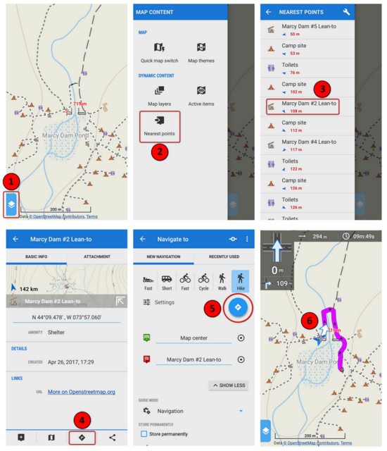
Nearest points. You can have Locus Map display a list of POIs sorted by distance from your current position. Select a POI to display it on the map then (optionally) have Locus Map guide you to it.
http://docs.locusmap.eu/doku.php?id=manual:user_guide:mainscr_lpanel#nearest_points

Touch the map with two fingers and it'll show you the distance between the two points (and optionally the bearing).
http://docs.locusmap.eu/doku.php?id=manual:user_guide:functions:measure

Speed auto-zoom. The map's zoom-level is automatically adjusted based on your speed. Map zooms in when you're moving slowly and out when fast. You predefine the thresholds for speed and zoom-level.
http://docs.locusmap.eu/doku.php?id=manual:user_guide:maps_settings:misc#speed_auto-zoom

Distance/time rings. It can display concentric circles around your current position. Each circle either represents the estimated travel time (based on your current speed) or the distance from your current location.
http://docs.locusmap.eu/doku.php?id=manual:user_guide:maps_settings:misc#speed_auto-zoom

Weather forecast. It can report the weather forecast for the area currently displayed on the map (you have to have an internet connection). The developer plans to store a basic weather forecast with a recorded track. You'll be able to look back at a track and see what the weather conditions were like at the time.
http://docs.locusmap.eu/doku.php?id=manual:user_guide:functions:weather


PS
If you enjoy geocaching, Locus Map provides extensive support for this activity.
http://docs.locusmap.eu/doku.php?id=manual:user_guide:geocaching:gc_in_locus
 
Last edited:
Thanks for the input. I downloaded the Locus Maps for $8 and have been playing with it. I got the 3 free maps and like everything so far. I'll put it to the test in a few weeks. Thanks!!
 
I hope it meets your needs and expectations. Should you have any questions, please feel free to contact me and/or direct them to the Locus Map community.

Although English is the "designated language" for the community forum, it's a multi-lingual European community so some of the posts show signs of machine (mis)translation. To avoid awkwardness, I've found it useful to steer clear of English idioms and colloquial expressions.

There's also an older forum that is frequented by Czech and German users. However, I've noticed that in the Versions sub-forum, the developer and power users discuss bugs and beta versions in English.

FWIW, here's a visual example of the "Nearest points" feature. Tap "Nearest points" to show nearby POI's, select a lean-to, view its info, select navigation, choose the navigation mode (Hike), and then follow the route.

 
I highly recommend Backcountry Navigator Pro ($9.99). It has never failed me and, when I've had questions, the support has been very responsive. I recently purchased Gaia GPS in order to do a comparison, but had several problems with it and essentially I found it to be inaccurate (particularly with elevations) and the support was not at all helpful.
 
2) Total ascent can be calculated using a Digital Elevation Model (DEM).
This was an important feature for me. Calculating total ascent using GPS altitude data is not without problems. In my experience, the algorithms used to "smooth" the data, to produce realistic values, would often produce overinflated results (my reference was many trips recorded with a barometric altimeter). If your phone has a barometric altimeter, many navigation apps can use it for altitude measurements and calculate a more realistic total ascent. However, my phone does not have this sensor. Locus Map can calculate a track's total ascent using a DEM (SRTM - Shuttle Radar Topography Mission). You can choose to have the DEM completely replace the GPS-recorded values for altitude (this is how I use it) or just use the DEM to optimize the recorded values.
The SRTM DEMs have a resolution of 30m (98ft)*, much coarser than of a consumer GPS. There may be significant differences in small regions containing large amounts of relief. (Think of walking along the top or the bottom of a vertical cliff...)

* Much of the world had SRTM DEMS with a 90m (295ft) resolution prior to the release of 30m data in 2015.

https://www2.jpl.nasa.gov/srtm/

Doug
 
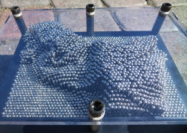
In case the folks at home are having trouble understanding SRTM and DEM, I've created a visual aid using a "Pinhead" toy (for creating 3D pin sculptures).


During the "Shuttle Radar Topography Mission" (SRTM), the height of the earth's surface was measured to create a Digital Elevation Model (DEM) of it. For the US, the spacing (distance) between measurements is 30 meters (~100 feet). So now look at the "Pinhead" image and imagine the distance between each pin is ~100 feet and its height is known.

You now have data to create a model of the earth's surface. Using some math (bi-cubic bla-bla-bla) you can interpolate the height between the "pins" and produce a fairly good representation of the actual terrain.

Is it perfect? No. However, we've been using topographic maps for ages and they're not perfect either. As any bushwhacker will tell you, there can be some surprising terrain hiding between the contour lines. Similarly, a DEM can lack (or even mistakenly invent) surprising features.


Back to GPS. Here's a simple experiment: use your GPSr to record a track while you walk for a mile along the seashore (or some other flat, level terrain). Ensure it is using GPS exclusively for vertical measurements (i.e. no assistance from a barometric altimeter). What it reports for "total ascent" may surprise you. It won't be zero.

The small errors in vertical measurement don't matter much when you're standing still. You're on a summit and your GPSr indicates 4320 feet. You check it periodically and it says 4315, then 4319, 4322, 4325, etc. Bah! It's around 4320, good enough! However, over the course of a hike, those "pennies" can add up to some serious money. Typically, the reported total ascent will be inflated which may be fine for one's hiking ego but objectively wrong.

The solution employed is typically a mathematical "smoothing function" to eliminate spurious values and produce a realistic value for total ascent. Typically you're given some control over how much smoothing is employed. Therein lies a problem because you don't know how much smoothing is needed to arrive at a realistic value. In addition, the amount of smoothing needed can vary based on the terrain.

Of course, none of this may be important to you. Your phone app says you climbed 5900 feet from Pinkham to Washington's summit and you take it for gospel. Living in a fantasy world makes life simpler.

Based on my experience of using several phone apps over the past year, using a DEM for total ascent produces results that are much closer to reality. "Reality" is (lots of) data recorded by JoeCedar using a barometric altimeter (Suunto X6M). To be fair, this issue may not affect all phones so YMMV. Joe uses a completely different phone (iPhone 5s) and both of the apps he uses produce reasonable results for total ascent (although not identical results). It's not perfect but far better than the ego-stroking values my phone (Moto X Play) was generating. I recorded tracks using several apps running concurrently and all produced inflated results for total ascent (and not necessarily in agreement). We haven't expanded our experimentation to other phones so we can't say for sure whether this is due to iOS v Android (doubtful) or just a flaw in my phone model (maybe) or only my phone (possibly).

FWIW, the topo map says my home is located at an elevation of 31 meters. Locus Map (using SRTM DEM) reports 31 meters. Locus Map using the phone's GPS reports values from 14-16 meters (when locked on to 6-8 satellites with 3m horizontal accuracy). For my purposes, I prefer to use SRTM DEM but, as always, YMMV. Test both and see what works best for you. It's nice to have options.
 
Last edited:
"Reality" is (lots of) data recorded by JoeCedar using a barometric altimeter (Suunto X6M).
We should note that barometric altimeters also have errors and various forms of smoothing can be used in the hope of reducing the error of an estimate of the total climb and/or descent. They are also affected by the humidity profile, the temperature profile, and changes in the ambient pressure.

In general the total climb and descent are fractals (ie the value depends upon how it is measured) and have no fundamentally correct value. In the special case of a monotonic ascent or descent the value is the difference in altitudes of the start and finish points, but most trails are not monotonic.

In other words, different devices and methods will give different answers and there may be no way of determining which is more accurate--pick your own poison. I'm generally content if several methods are within 5% or so for total climb and distance.

Doug

PS. It has been covered in other threads, but trail distance is also a fractal and therefore there is no fundamentally correct value.
 
To say there is "no fundamentally correct value" is fine for philosophers but not cartographers. At the end of the day, "no correct value" is replaced by "good enough for all practical purposes".

I agree with you in principal but in practice there is a point where the fractal aspect makes no appreciable difference for hikers. It may not be possible to agree on a trail's distance or ascent with millimeter accuracy but it is possible to arrive at something to within (tens of) meters ... which is "good enough" for the purposes of hiking.

Like a road, a trail follows a fairly narrow corridor so on the order of human locomotion, you don't have a lot of room to improvise a dramatically different route unless you purposely choose to do something unusual like a lot of very tight zig-zagging. In addition the terrain shepherds the hiker to follow a path very similar to the one taken by the previous hiker (minor variations are determined by one's skill, stride length, trail conditions, etc). The minor differences (around or over that boulder) don't add up to something that makes one hiker travel 15 miles and another 16 miles on the same path (perhaps a tenth of mile or less).

Similarly, many measurements for total ascent will reveal a locus of values around the most realistic one. The mountain's height certainly isn't changing appreciably (on a human scale) so there's definitely a "practical value" for hikers.

Joe's an ADK Grid finisher so he has, dare I say, a mountain of recorded data. :) He has recorded many "out and back" hikes so changes in atmospheric pressure over the course of the day (if any) would appear in the discrepancy between starting/ending elevation. In addition, he compensated for the affects of temperature for his winter hikes. Long story short, data for many hikes to "out and back" destinations, like Allen and Seymour, would produce results that were in agreement to well under 5%. Knowing we had realistic "baseline" values, for certain Adirondack summits, we could compare them to our phone apps. In his case, he was reasonably pleased with his phone's results (comfortably close to the baseline values) but I wasn't (the results were far too generous). By switching to a DEM, I got results that were much closer to the baseline values (typically slightly lower).

Over the past seven years I've read many trip reports (on ADKHP) containing values for total ascent reported by the individual's GPSr. Some were so totally implausible it made me realize people just took this stuff on faith. "The GPS says so." The reported value would sometimes wildly exceed even a first-order approximation of the total ascent (highest elevation minus lowest elevation and then include a few of the largest PUDs). Like I said earlier, good for the ego but it doesn't represent objective reality.
 
Last edited:
You could also say the distance, in the special case of a "monotonic trail" (a straight line), is the difference between the start and end point, could you not? Chances are good that the error is much higher than the elevation case, I bet... my experience has shown some reasonable straight hypotenuses on the elevation profile but not the trail/track on the map (some roads approach straight lines for extended distances while road cycling.)

Tim
 
You could also say the distance, in the special case of a "monotonic trail" (a straight line), is the difference between the start and end point, could you not? Chances are good that the error is much higher than the elevation case, I bet... my experience has shown some reasonable straight hypotenuses on the elevation profile but not the trail/track on the map (some roads approach straight lines for extended distances while road cycling.)
I don't think the concept of monotone can be extended to the 2D case (altitude is 1D, position is 2D), however a straight line is a special case which allows a number of simplifications.

I'll leave out the issue of how one determines that something in the real world is indeed straight or how straight is straight enough... (Probably a can of worms.) A lot depends on how accurate is good enough for one's purposes which could vary for different users.

Doug
 
To say there is "no fundamentally correct value" is fine for philosophers but not cartographers. At the end of the day, "no correct value" is replaced by "good enough for all practical purposes".
Cartographers and surveyors are very aware of accuracy issues. For instance, there are published accuracy specs for USGS topos. And a surveyor should be able to tell you the accuracy of any point that he has located.

I agree with you in principal but in practice there is a point where the fractal aspect makes no appreciable difference for hikers. It may not be possible to agree on a trail's distance or ascent with millimeter accuracy but it is possible to arrive at something to within (tens of) meters ... which is "good enough" for the purposes of hiking.
My point is that one should be aware of the errors whatever they are.

IMO, a few tens of meters would be pretty optimistic for a full day's hike with lots of twists and turns and ups and downs.

You have presented a method for determining total climb that has at least one obvious weakness. If you are happy with it, fine, but IMO your case is weak. In some terrain, it is probably good enough, but in some other terrain it is likely not very good.

In the absence of a fundamentally correct value or baseline data with a proper error analysis showing errors that are "small enough" it is very hard to show that one proposed method is more accurate than another proposed method. You may only be able to show consistency between two methods--consistency is necessary, but not sufficient to show accuracy.

Other items:
* Many GPS users don't know their limitations or how to use them effectively.
* In ideal conditions (good skyview, good satellite constellation etc) most GPSes will give similar results. In less than ideal conditions (eg when hiking) the poorer units become less accurate. (For example, I have made a direct comparison between an Iphone 4s and a Garmin 60CSx on a hike--the 4s track showed some unreasonable large excursions from our route, the 60CSx track did not.) Many of those unrealistic trip computer numbers likely come from such excursions.

Yawn,

Doug
 
You stated there's "no fundamentally correct value" (here and in other posts) like it's the unattainable pursuit of the Holy Grail because, fractals. There is an acceptable value as far it pertains to hiking and, for the average hike, it only needs to be accurate to within tens of meters (arguably even a half klick) to be more than acceptable to the vast majority of hikers. Certainly not good enough for other activities, like sprinting or surgery, but more than adequate for a 15 km hike.

... IMO your case is weak. In some terrain, it is probably good enough, but in some other terrain it is likely not very good.
I welcome the opportunity to learn about the methodology and data you collected that supports your claim.

In the absence of a fundamentally correct value ... it is very hard to show that one proposed method is more accurate than another proposed method. You may only be able to show consistency between two methods--consistency is necessary, but not sufficient to show accuracy.
Sure but in this case the "fundamentally correct value" has traditionally been extracted from a topographic map. Land surveys, photogrammetry, radar altimetry, etc helped produced the topos that continue to be used by hikers to this day. It serves as the long-standing baseline and used to calculate ascent values published in (older) guidebooks (... unless they employed an altimeter).

If a barometric altimeter reports elevation and total ascents consistent with topo then it has established a degree of trust. If a consumer GPSr tells me the total ascent is substantially higher (like by 25-50%) then I have good reason to doubt it. Especially when it does that for even level stretches of terrain. The route is self-evidently flat yet the device records an appreciable ascent. Well, well, that's a nasty little characteristic that doesn't inspire confidence.

This whole thing started when I hiked to Seymour and the app pulled an extra 300 meters of ascent out of thin air. Most of that was accumulated over the initial 8km of level/gradually-ascending terrain. Completely unsupportable by topo map and, especially, by the amount of expended effort. Screw it. I switched to a DEM because it produces ascent values consistent with topo and altimeters.
 
Last edited:
Top