Asquam-Ridge Trail on Moosilauke

vftt.org

Help Support vftt.org:

This site may earn a commission from merchant affiliate links, including eBay, Amazon, and others.

Raymond

Well-known member
Joined
Sep 4, 2003
Messages
1,536
Reaction score
59
Location
My gut is telling me no... but my gut is also very
Just curious. Why was the trail relocated over Mount Blue and away from the edge of Jobildunk Ravine? Was it beginning to slide off the side of the mountain? There weren’t really any good views of the ravine.
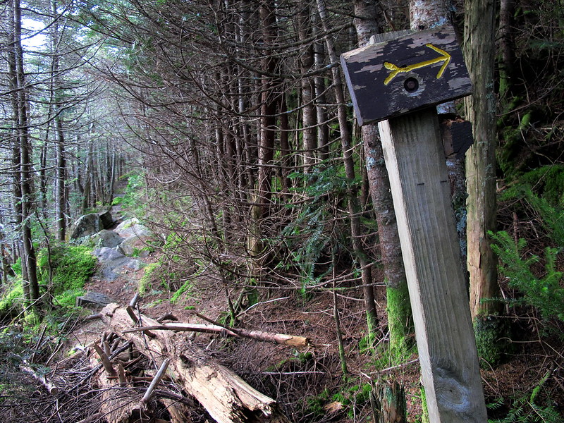
10495871216_d824f3af8c_c.jpg


Also, there was a faint herd path well before Mount Jim that went off to the right/east. It didn’t really seem like it was near the top of a mountain, but does it lead to the summit of Mount Waternomee? I should have followed it further than I did, but I didn’t even begin my hike until 12:50 p.m., and I didn’t know how long it might take me to complete the loop, so I didn’t explore as much as I would have liked. (Spending almost 30 minutes on top of Moosilauke, and descending to South Peak, then taking the Carriage Road to Hurricane Trail, I got back to my car at 6:40 p.m. Didn’t see another person the entire time, so I really felt like I had the mountain to myself. This was last Monday, October 21st.)
 
Are you talking about the Al Merrill ski loop which leaves shortly after the brook crossing and returns near the ridge? IIRC, Waternomee is still a short bushwhack.
 
The trail was relocated when the AT corridor was finalized over Moosilauke in the early 90's. The corridor is 1000' wide and if we kept the trail where it was someone would need to do a land survey right through the heart of Jobildunk Ravine. Instead, we put the trail right along the property line along the ridge and could re-use that survey line.

The old trail also went by Deer Lake and had a bit of swampy sections, but that's not why we moved the trail.
 
Roy, I meant a section of the trail below Mount Blue, where the trail makes a more-than-90° turn to the right and climbs up to the herd path to Blue’s summit. The trail apparently used to continue straight ahead, as seen in my photo above. I guess Dave answered the question, that it would have been near the AT corridor, so it was relocated. I had wondered if there might have been a washout or something and become too dangerous, but apparently that wasn’t the case.

The Al Merrill Loop rejoins the Asquam-Ridge Trail well below Waternomee, as far as I remember. I climbed up Asquam-Ridge Trail with the idea of hitting all three subpeaks, and I half-expected there to be a herd path leading to each peak’s summit, so when I saw that faint path, I thought it was the one for Waternomee, but the trail was still climbing in elevation, so I continued on until I found a more obvious herd path, which led maybe 30 feet to the right. When I checked my GPS, I saw that I was on Mount Jim, and I had missed Waternomee. So I was just wondering if that herd path — if it even was a herd path — led to Waternomee’s summit or to something else. I see that there is a plane crash on the other side of the mountain, so maybe it leads around to that. And maybe Waternomee doesn’t even have much of a summit, I don’t know.

On the National Geographic Topo! I can also see that there used to be a Ridge Trail and an Asquamchumauke Trail. I assume the two were more or less combined into the present Asquam-Ridge Trail. The Asquamchumauke Trail is mentioned in ‘‘The 4000-Footers of the White Mountains’’ as having been discontinued in 1973.
 
The plane crash is well below the summit, it's much easier to reach from the other side. As far as I know there's no herd path to it from the Ravine Lodge side of the ridge. I don't think there is a well defined herd path to Waternomee like there is to Blue and Jim.

The old Asquamchumauke trail went through the heart of Jobildunk Ravine along the Baker River. Big chunks of it are now under a swamp. The start of it can still be found branching off from the Ridge trail just after the major stream crossing down low. It connected to the Ridge trail near the junction with Beaver Brook but the upper parts are nearly impossible to find.
 
A bit off topic but is the Moosilauke Ravine Lodge open year round and the road that leads to it? My eyes were drawn to this thread because I'm planning a hike there soon. I see on the Lodge site that they welcome the public and there are several references to different seasons as well as skiing so I assume it is but I didn't see anything explicitly saying it was a year round spot. If anyone know I'd appreciate the info. Also, do they charge any fees for parking and/or facilities? About a 3hr 45min drive to that road for me. Hate to find it closed when I got there. Thanks.
 
Thanks for the information about the Asquamchumauke Trail, too, Dave. I was wondering why it had been closed.

DayTrip, there was a gate at the very beginning of Ravine Road, so it may close at some point. While it remains open, the only rule seems to be to park along the side of the road, not in the turnaround at the very end.

The Asquam-Ridge Trail had its beginning relocated after Hurricane Irene, so if you have an older guide book, it will not reflect that. Just follow the logging road out of the far end of the turnaround.

You used to have to descend near the lodge, then follow the west side of the river. Now the trail stays on the east/right side before crossing to the left on a bridge. Later, it crosses back to the right and begins to climb.
 
You used to have to descend near the lodge, then follow the west side of the river. Now the trail stays on the east/right side before crossing to the left on a bridge. Later, it crosses back to the right and begins to climb.
Actually while the "official" route changes back and forth with the whims of the DOC, going straight from the parking lot has worked for 40 years or so
 
A bit off topic but is the Moosilauke Ravine Lodge open year round and the road that leads to it?
The Lodge closes around the end of October. The road gets gated roughly the same time as other FS roads but it's often pretty difficult to drive in November as the road gets icy. Once the gate is closed you need to park at the plowed out area on Rt 118. It used to be a USFS Fee parking area but I believe it no longer requires a pass.
 
I hiked out of there Sat 11/2 and gate thankfully was still open. I didn't see a fee tube at the end of the road near the "map kiosk" on Rte 118 but I didn't take a super close look. Was psyched the gate was open. The road has a lot of pot holes, frost heaves and jutting rocks but even in my tiny Hyundai I was able to negotiate. Road is narrow in a lot of spots for two way travel too. Had a few close encounters driving out. Wouldn't want to be doing that in icy conditions. Thanks for the info Dave.
 
Top