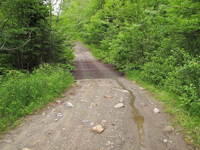
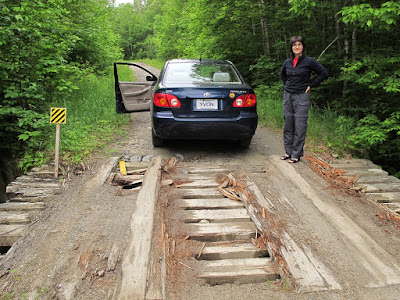
Caribou Valley Road - repaired!

vftt.org

Help Support vftt.org:

This site may earn a commission from merchant affiliate links, including eBay, Amazon, and others.

Damselfly

Active member
Joined
Apr 16, 2008
Messages
280
Reaction score
37
Location
Meredith, NH
I apologize if this has already been posted... but while up in Stratton, ME, we checked out the CVR... and the bridges and eroding culverts have been repaired. We drove 2 miles up in a low clearance Honda Fit with no problem. Incredible! Last summer, the road was a mess... and to see it all smooth with new wooden bridges and culverts.... !!! I'm psyched, as my husband and I are returning later this summer for a short backpacking trip.

Beth Zimmer
btzimr at gmail dot com
 
Great news, I expect many will appreciate your post.

Of course now I expect that there will be active logging somewhere in the area.
 
Last edited:
The bridges and culverts were so nicely done... that I wonder if the monies came from Hurricane Irene disaster funds. Grass seeded along the banks... too nice to be done by a logging company.
 
Thanks for the info!!!
Remind me, please, how far two miles is? Did that get you to the parking area before the green metal bridge? Past the bridge to the AT crossing?
 
Some things to consder

http://www.fountainsamerica.com/land/propertyDesc.aspx?Id=318 this land which appears to be on the north side of the range has been for sale for awhile.

The Federal government recently bought a conversation easement in the area

http://highpeaksalliance.files.wordpress.com/2009/02/final-project-listing-from-fs-website.pdf

The easement precludes development but allows logging.

In general, I beleive that there in an incentive to maintain emergency access to the area and the area has recovered enough from the budworm epidemic that its time for "prescriptive" harvesting. Both of these driverc could have driven the road repair.
 
In general, I beleive that there in an incentive to maintain emergency access to the area and the area has recovered enough from the budworm epidemic that its time for "prescriptive" harvesting. Both of these driverc could have driven the road repair.
By emergency,I assume you mean forest fires for the most part? There aint much back there[not counting a.t. on right]...thanks for links peakbagger....
 
Emergency would be firefighting and probably needed on occasion to find some Navy Folks who wandered over from the Navy facility.

By the way, logging companies now have to comply with SFI certification and Atlantic Salmon rules both require a far more responsible approach to logging and the building of roads.Having to grass in banking is SPO these days as well as making culverts "fish friendly"
 
Last edited:
This was the end of the line for us on Sunday 7/1! Pretty sure we passed the three mile marker before we came to this spot.

We were in a Subaru Forester, but we noted 2wd vehicles where we parked, including a Prius and a Civic.

p170030044-4.jpg
 
Blaze, that looks like the metal grate bridge, with a parking area before it, a steep grade up just past it, all of which is before the AT crossing?

IMG_2588.jpg
 
Last edited:
Blaze, that looks like the metal grate bridge, with a parking area before it, a steep grade up just past it, all of which is before the AT crossing?

IMG_2588.jpg

Correct - we parked on the left (there was room for 5 vehicles at least) then road walked ~10 minutes to the AT crossing. Which by the way is not signed... keep your eyes out for rocks w/white blazes on both sides of the road. If you get to Mt Redington you've gone too far. =)
 
redington

for official peak bagging, does one have to park where blaze did and hike from there, or can one bike further up? I'm guessing park where blaze did.. is taking logging rd.'s up o.k., or is the herd path from crocker the official way? who will answer 1st, Michael J., peakbagger or somebody else? thanx 4 the rd. update!
 
Me thinks if you are working on the AMC list that since Plum Creek closed and signed the road, than thats where you park and start walking. I figure its about 9 miles in and out via the road and the pond . The bushwhack from Crocker now looks like the way to do it unless Plum Creek moves the gate. I expect a runner could run the road faster than the hike up Crocker and the bushwhack over and back, but I am not a runner;)

I have a suspicion that most folks doing Reddington are out for the AMC NE 4000 footer list, so according to the Rules http://www.amc4000footer.org/faq.htm#rules2 no bikes past the road closed sign.
 
peakbagger for the win!

thanx, bushwhack it'll be, been about 5 years since crocker's so why not?:) I'll make sure to wash down the hike with mt. biking @ loaf outdoor center and a cruise on the narrow gauge trail!
 
I'd have to agree -- the road is closed to vehicles and you can only use a bicycle on a road open to vehicles on the day of your hike. Before the road was "closed", there was wiggle room as the standard was fairly easily passable to an average four-wheel-drive vehicle (not an ATV) without "heroic measures" such as winches. (If you think a jeep might not make it, then please walk.) Thus I would have felt justified in riding a bike a good way to Redington having seen a Jeep CJ4 all the way down to the pond. Not that it mattered since I did Redington from South Crocker, but I did walk the road back, and it would have been fun and faster on a MTB.

Tim
 
We didn't drive all the way to the metal grate bridge, because it was getting dark and our friend was new to driving dirt roads. But if we can get to the metal grate bridge as suggested above, we're all golden. We passed a van with some young thru-hikers getting drunk and high... heading back to the trail. :)

Steve still needs five of the peaks out there, so we're heading up for a two day backpack to hike them. The road repair is really good news.
 
Top