Compass bearing for BB

vftt.org

Help Support vftt.org:

This site may earn a commission from merchant affiliate links, including eBay, Amazon, and others.
If you do, don't forget to stop in the middle of a snow bridge and tell a story. That's Becca in the background looking at the ground. Probably heard the story at least a few times :D


WAAAAY too funny!!!!!


ALSO, @Royswkr, "If you put a physical object in the middle of the bushwhack, would the rangers find it?" --is that like if a tree falls in the middle of the forest.... :D

I think as long as one doesn't maintain the Owl's Head Path (were there signs about fines there? I cannot remember), one should be OK - what's a memorial cairn or 2 amongst friends on a bushwhack???? :D

ALSO, @bikehikeskifish: AWESOME visual for that last one!!!
 
...p.s. Kevin - at a glance I'd say the major difference in the tracks is that Brutus stopped at the traditional summit, otherwise the shape looks nearly identical.

Yes, that's right. That hike occurred before the "official" summit moved.
 
I actually wondered if it would be worth dropping off the summit to the east, and trying to get down to Franconia Brook Trail, but it looks like there are a lot of waterways at the bottom, and I had no idea how much of a mess that would be for trying to get across to the trail.
I've done that several times, it's better in winter when the stuff at ground level is buried and you can slide a lot of the way. Yes there is a maze of channels and islands where you probably come out instead of one big stream, you probably also have to cross Hellgate Brook which is usually easy.

It is farther to the trail bushwhacking E instead of W, but it's a shorter and easier trail once you get there.
 
I wouldn't be against a couple of memorial plaques/cairns honoring Brutus at the start and end of the bushwhack!

Thanks, everybody! I may do a memorial hike in May.

If you put a physical object in the middle of the bushwhack, would the rangers find it?

I do believe that Brutus has been immortalized in the digital realm. That will likely last longer, and be seen by more people, than most plaques. :):(
 
Just did the Black Pond bushwhack today to check conditions for my hike on the 28th. Followed a 345 magnetic course and stayed above the swamp. Best trek yet.
 
Personally, I prefer the Bachelorette Bushwack to the Brutus...but it's location is not discussed on the 'net: what happens at the bachelorette party - stays at the bachelorette party. :)
 
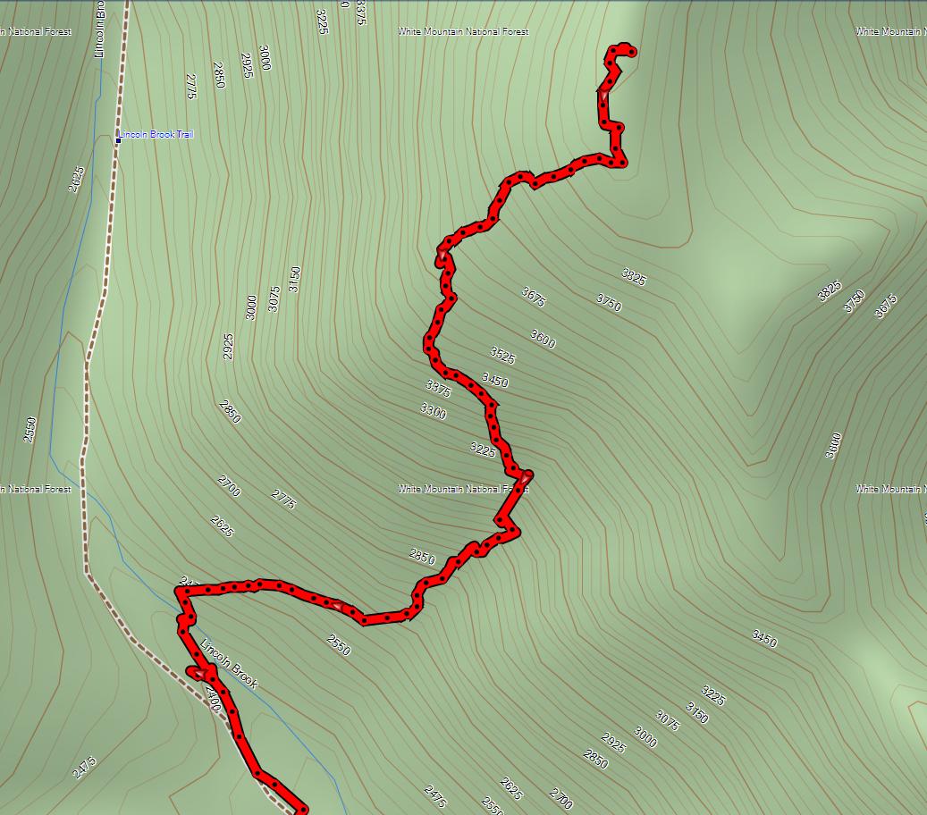
The track of the original BB is below:

bb1.jpg
I'm not sure where the base map came from, but if you believe it the BB leaves well BEFORE the last crossing...
 
Roy - you have sharp eyes. The basemap is Garmin's, from their Topo 2008 series. They've drawn the brook in the wrong place. The BB starts anywhere from 100' to 300' after you cross the brook. Where you start up isn't too important, as initially it's all a steep, brushy bank, but that part doesn't last long, and soon it opens up. But, since you're going to go right anyway, it's doesn't make much sense to continue along very far along the trail as you just will have to backtrack a bit higher up.
 
Thanks everyone. Becca, that was the exact trek we took last time I did the BB with Earl et al.

The route Becca describes had basically become a herdpath last two times I used it - should be easy to find and follow. ;-)

As Kevin points out, the lower entry is the only sketchy part but it's easy to
Spot the embankment above the trail to the south just after crossing the stream - scramble up through fairly open woods and the road is obvious

Happy trails
 
Last edited:
The basemap is Garmin's, from their Topo 2008 series. They've drawn the brook in the wrong place.
The brook location may be a little flaky (compare it to the contour lines) but I think the trail is wrong too. It looks like your track log is probably on the trail until after the brook crossing when it suddenly zags uphill, hence the trail crosses sooner than shown. The Garmin map seems to follow the USGS map which shows the crossing at about 2500' whereas the 2003 AMC map shows the crossing at 2400' which is maybe .2 miles S. The AMC map however shows the slide path too far S and going to 4025 which of course it didn't. The excuse I have heard is that since it wasn't an official trail the AMC didn't GPS it although it uses the same linestyle as official trails.

Conclusions:
* Both maps show the slide too close to the last crossing which may be one reason people have trouble finding it
* If you load the Garmin map into your GPS and try to follow the trail route shown on it, you may be bushwhacking :)
 
The brook location may be a little flaky (compare it to the contour lines) but I think the trail is wrong too. It looks like your track log is probably on the trail until after the brook crossing when it suddenly zags uphill, hence the trail crosses sooner than shown. The Garmin map seems to follow the USGS map which shows the crossing at about 2500' whereas the 2003 AMC map shows the crossing at 2400' which is maybe .2 miles S. The AMC map however shows the slide path too far S and going to 4025 which of course it didn't. The excuse I have heard is that since it wasn't an official trail the AMC didn't GPS it although it uses the same linestyle as official trails.
Kevin's Garmin Topo US 2008 background map appears to be plotted on the 500 ft scale. Agreed--the river location does not match the topo contours. However Garmin's USTopo 24K National Parks, East v2 does place the river in a spot that matches the contours. Plotting the WMNF trail track on the 24K map shows the crossing to be at 2400 ft (very close to the apparent crossing in Kevin's track).

The trail as shown on the above topos differs from the WMNF trail track in a number of spots.

Kevin: if you send me a copy of your track I can plot it on the 24K topo and see where it fits in and post an image. (I think you have my email address--if not, let me know and I'll PM it to you.)

Doug
 
Last edited:
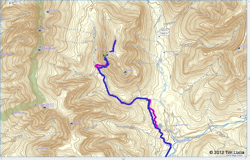
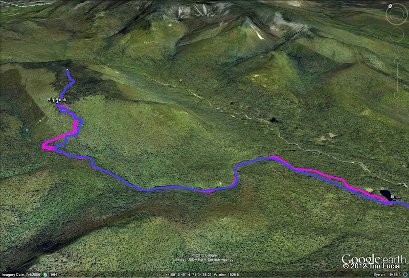
I went with Jazzbo, Scott, Dave, Ken and Karen last Sunday on that really cold, (-4 on top) day. I thought I would share the overlaid tracks from 2010 and 2012.

2010 is in blue. The Black Pond route was higher and straighter, and the Brutus whack went up the hill sooner, followed the road all the way to the gully, where it ascended more steeply. LOA: 16.4 miles.

2012 is in magenta. This time, we went much lower on Black Pond, maybe the fisherman's route (there was some orange surveyor tape. The last tenth or two avoided the steeper, sprucier descent to the Lincoln Brook Trail that we encountered in 2010. The Brutus whack starter further along the Lincoln Brook Trail, and was generally much easier to get up to the old road. There were tracks turning left on the road, in fact, which may indicate (and so I heard that it does) the road comes down to meet the trail. We stayed on the road for a shorter distance and then headed up hill. LOA: 16.5 miles.

2010%2520vs%25202012%2520-%2520Garmin.jpg


2010%2520vs%25202012%2520-%2520Google.jpg


Hope this is helpful to people,
Tim
 
This time, we went much lower on Black Pond, maybe the fisherman's route (there was some orange surveyor tape.
The fisherman's route starts at Franconia Falls and stays close to the brook the whole way, with a spotty herd path
 
Top