Desolation to Isolation

vftt.org

Help Support vftt.org:

This site may earn a commission from merchant affiliate links, including eBay, Amazon, and others.

sapblatt

Well-known member
Joined
Oct 22, 2004
Messages
2,177
Reaction score
286
Location
Massachusetts Avatar: "Heads or tails?!"
Planning on hitting Carrigain next week. Can anyone tell me about the Desolation Trail? I would prefer to make a loop going up Desolation and down Signal Ridge. I know it is damn steep (1.9 miles/2500 feet). Can any of you compare it to some other trails in the Whites? Scrambles? Leges? Slides?

Thanks!
 
sapblatt said:
Planning on hitting Carrigain next week. Can anyone tell me about the Desolation Trail? I would prefer to make a loop going up Desolation and down Signal Ridge. I know it is damn steep (1.9 miles/2500 feet). Can any of you compare it to some other trails in the Whites? Scrambles? Leges? Slides?

Thanks!
I would compare Desolation Trail to the below treeline section of the Osgood Ridge Trail going up Madison. It's not too bad... I found that it's steep but gets you to the top really quickly. No scrambling... just rock steps. Look out that you don't trip on the old phone wire the book rec'ds.

It's a great loop. Look for views to Eastern Flank of Hancock.

-Dr. Wu
 
Haven't done Desolation but I can tell you that I remember signal ridge up to Carrigain as a pretty long walk. I would have prefered to just go down also. :D The thing I remember most about going up was that just when you thought you were there. You discover that you have to go down through a col and up again to get to the actual peak. :D

Really great mountain views though. Well worth the effort.

Enjoy your trek.

Keith
 
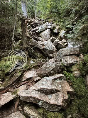
We went through Carrigain Notch and up the Desolation Trail for a change and it became one of our favorite hikes. Here is a shot of the upper, rougher section of the trail.

DesolationTrail.jpg


It makes a great approach to Carrigain and Signal Ridge is an easy cruise down to Sawyer River Rd.

sunfish
 
SteveHiker said:
from the title of this thread, I thought you were going Dr Wu on us.

Desolation to Isolation would be one impressive dayhike. Be careful when crossing 302.
Going "Dr. Wu"?!

If you simply went from the Desolation Trail to Isolation, it wouldn't be too bad. You'd have to walk Sawyer River Road and a little walking on Rt. 302 to get to Davis Path. I imagine if you camped at the illegal Desolation Shelter Site, hiked to Isolation and illegally camped near the summit you could do it in a day!

Wow though, I don't remember the Desolation Trail being so rough near the summit. It was a lot of fun towards the end, that's all I remember.

-Dr. Wu
 
no offense meant. It just sounded like the type of thing that you propose from time to time. I guess it's not as far as I thought, but it would still be out of the ordinary.

I was thinking going out the Nancy Pond trail, so there'd be less road-walk, but your way would work too.
 
SteveHiker said:
I was thinking going out the Nancy Pond trail, so there'd be less road-walk, but your way would work too.
No, obviously I wasn't thinking. I'd take Nancy Pond Trail over most trails, let alone boring (Sawyer) and potentially dengerous (Rt. 302) road walks!!!

Mike, I think we've routed your hike for you! Carrigan to Isolation in a day!

-Dr. Wu
 
No Blazes

sunfish said:
We went through Carrigain Notch and up the Desolation Trail for a change and it became one of our favorite hikes.
It makes a great approach to Carrigain and Signal Ridge is an easy cruise down to Sawyer River Rd.
I did this loop a few years back and thoroughly enjoyed it. The approach to the start of the Desolation Trail is relatively easy so it's not as much more difficult as the mileage might suggest. I actually liked going up Desolation more than I liked going down the section below Signal Ridge (but that was mostly because I was shocked by the degredation of the latter since my first visit in 1989 - the rock in the treadway seems to be crumbling away making for less secure footing).
Be aware that unless things have changed (and since it's in a Wilderness area, they aren't supposed to), there are no blazes on the Desolation Trail or on the backside of the Carrgain Notch Trail. The trails are not hard to follow though and as long as you pay attention to your map at the junctions, you shouldn't have any problems.
The disturbing part was that the blazes on the CN trail had been cut out of the trees!!! I can see prohibiting any reblazing but who though they were doing Wilderness a favor by scraping them off?! Although it would be less noticeable now, for us it was just a matter of looking for light wood colored blazes instead of blue ones. Was this perhaps some kind of compromise blazing???
 

Latest posts

Top