Elephant Mountain (NEHH) access from AT?

vftt.org

Help Support vftt.org:

This site may earn a commission from merchant affiliate links, including eBay, Amazon, and others.

Guthook

New member
Joined
Jan 19, 2009
Messages
401
Reaction score
28
Hey folks,

I'm planning on hiking a section of the AT starting early next month, and if I can get to Elephant Mountain, I may try to knock that off my NEHH list. I've been through that area three times before on the AT, but I don't remember the Clearwater Brook Trail (marked on USGS quads) being maintained or signed. I do remember seeing what looked like a herd path somewhere in the area, but I can't remember exactly where.

Does anyone know if the Clearwater Brook Trail is still accessible from the AT, or if there's a better route from the AT to the summit? The route described here seems to follow close to the old trail (which may just be marked incorrectly on old USGS maps), but I wouldn't want to assume anything.

Cheers!
 
Don't know how relevant this is but we did Elephant 10 years ago and even then the CB trail was next to impossible to follow or even find. We went in on the AT via Old Blue and there was a sign at the Old Blue - Elephant Col but the old CB Trail was not mentioned on the sign. So we kept on the AT to the height of land and the took a bee line to the NE peak (which used to be considered the higher). We got a little help on this part from the county line but otherwise it was tough going. Then we whacked the ridge line to the true peak staying a bit down to the north side and found the true peak.

It was much too much work and there was too little time to return to the AT, so we followed the traditional route (at least it was traditional at the time) from the low point on the Elephant Ridge line down towards the south to the clear cut (maybe not so clear today) and thence to the yarding area and took the logging road out to the ride we had arranged.

So we did not find the CBT at the top nor at the bottom. And our ride, a local Hostel owner, felt the same way. We told him we would come down the CBT to South Arm Rd., or take the logging road if we couldn't find it. He went straight to the logging road, knowing we would never find the CBT,.

Note that our route involved a drop off at the AT trailhead and a pick up at the logging Rd. With one car you would need a long walk on South Arm Rd. back to the AT trailhead. Or maybe just forget the AT. I would NOT suggest going in and out via the AT. It was tough for us just going in and not out.

FYI here's the detailed report: Old Blue and Elephant - July 2003
 
Last edited:
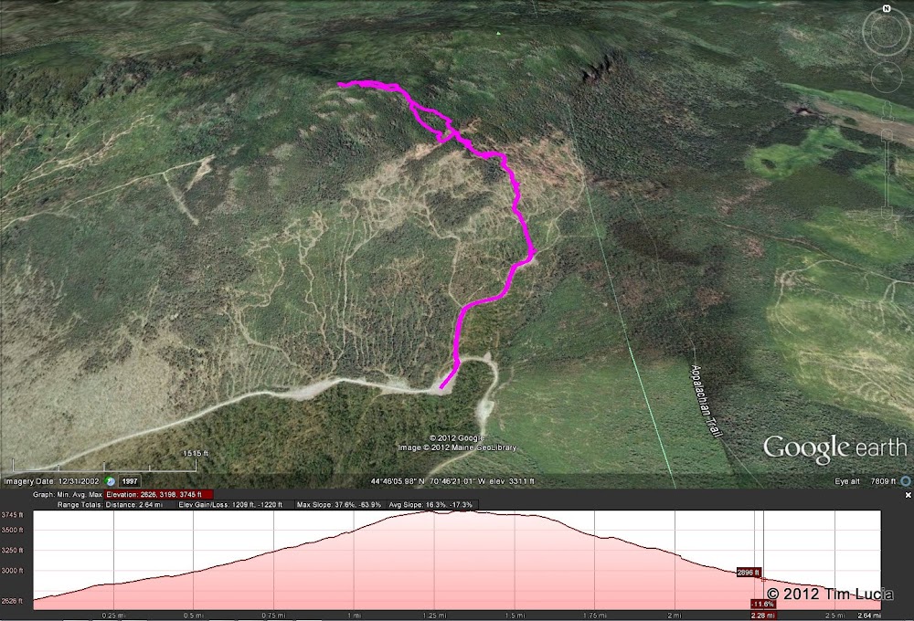
google%2520earth.jpg


Maybe this will help some...

Tim
 
Long ago we followed Clearwater brook trail (now closed at owners request). It was a pleasant route but in rough shape, We were surprised when we came out on a freshly built logging road almost at the height of the col. I think the current approach is via the logging road, assuming its still open. Via the logging road, you had better plan a short day.
 
Perfect. Thanks, all three of you! I suspected the AT wasn't a good route when all of the trip reports I'd seen came from the logging roads, so maybe I'll pass on the peak for this trip, since it'll be a backpacking trip on the AT. A day hike from the logging roads sounds like the preferred route.
 
My addition is probably not very relevant either, and if you're on the AT then this won't matter, but I found the CBT (western end) in August of 2004 from the logging road, so 9 years ago at this point. But as I recall, I eventually got on the trail which I stumbled across by following the brook generally east/northeast (staying on the north side of the brook). There were occasional open views to the north of Elephant from the trail/brook. At one point, I climbed up a small tree to get a slightly better view of the summit.

I ran into another bushwhacker heading to the summit that day. A guy named Craig - his approach was from further north than mine, and I remember thinking there was a moose or bear coming when I heard him - never thought anyone else was going to be out there. We hiked back out together the same way.

Maybe a Craig on here??
 
when i hiked elephant for the first time last summer via the current "standard" route from elephant mountain road i ended up walking about .5 of the clearwater brook trail out of curiosity and ended up on the a.t. at the time i had no idea what trail it was, but once i saw blue blazing i got curious. i picked it up at the logging landing about .2 from where you park with a cairn marking a left turn off the grassy logging road. almost immediately a flagged trail turns to the right where you want to continue straight on herd paths if headed to elephant directly. this flagging continued to mark the trail through a wet cut over area then blue blazes and a real foot bed appeared and i shortly found myself facing an a.t. sign as the signage at the old junction still exists. i would think a side trip to elephant from the a.t is totally reasonable. i don't have a map in front of me, but just heading up to the ridgeline direct from where the clearwater brook trail branches off could provide good access and allow a traverse of both summits.

bryan
 
Top