NeoAkela
Active member
Flat Top Mountain via "Hawthorne" Falls Slide Loop
Beech Slapped and Hobbled - the failed second Galehead attempt and the Wrong Falls Adventure!
What a fine Tuesday! Unfortunately, circumstances occurred early in the morning that put a damper on my original plans in the Wild River valley, so at the late hour of 1 PM I was finally free and searching for something to take up a short afternoon. I finally settled tentatively on Galehead, since it is nearly in my backyard, and despite several visits to Galehead hut, I have never actually climbed the Frost trail to the summit. I have some crazy aversion to actually completing the 48 list.....
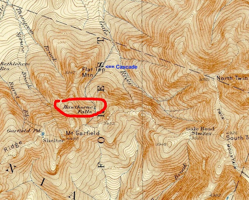
Ten minutes from home and I was at the Gale River trailhead. As I walked along the well-worn trail, my mind wandered a bit, recalling the history of the route. Back in 1954, a massive landslide necessitated the re-routing of this trail, which originally ran up a ravine further to the west, passing long lost Hawthorne Fall on its way up to the ridge. Somewhere up ahead was the turnoff for the old trail, just past the first crossing of Gale River and running up a western branch of the river to Hawthorne Falls. Perhaps I could go find it....
So, once again, Galehead was again thrown out the window (don't ask about the first time!) and new plans were made! Well, maybe I would do Galehead afterward....
With less than 2 miles to the first crossing, and an easy grade, the distance was covered quickly. The Gale River trail is extremely muddy, but not so much that a few rock hops wouldn't do the trick getting by. At the intersection with the river, a worn path appeared to continue straight ahead. I decided to follow that for a while and see where it led, since it was heading in the right direction.
The herd path followed the west side of the river for a while, slowly climbing the bank on the side as it got steeper and steeper. The river dropped further and further below, and the path finally seemed to peter out. I continued onward for a while through the tight scrubby trees. Just about the time I was about to head down the embankment and try to pick up the Gale River trail again, I spotted a pink ribbon tied to a tree. Then another one. This line of pink ribbons took me along a merry chase through the woods, up and down the embankment, before ending abruptly. I wondered again about people and their ribbon mazes in the middle of nowhere...
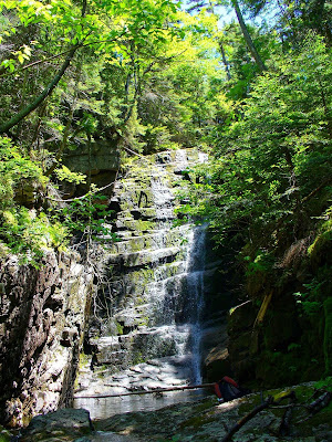
Cutting down the bank, I emerged on the edge of the western branch of the river. A few hops across and I was in the V between the two branches. A few moments later I came across an obvious old trail, complete with cut marks on branches and muddy footprints. The trail was well worn and easy to follow. Ahead, the woods got brighter and brighter, until the trail emerged into a large clearing on a huge slab of rock. The river streamed down the rock, falling over several cascades before settling into a pool at the bottom. Unless I was completely mistaken, this must be Hawthorne Falls!

The slabs above the falls were also beautiful, and I had a relaxing lunch. (Later, I realized that this was NOT Hawthorne Falls... oh well! Still, a very beautiful waterfall! Gives me something to check out again at a later date!)

Looking up, from the edge of the slab I could make out the cliffs of Flat Top Mountain over the trees. I could see several great perches right at the top, and it wasn't that far away. I decided to try and find the old slide that I had seen from photos from across the way. It wasn't very hard to find... at the top of the falls, the old slide comes down and almost touches the stream. At first, the slide was slippery slabs of rock, but there were enough handholds and branches that this was not a problem to navigate. Higher up, the slide switched between a rocky stream and wide open dunes of gravel.


In the largest gravel field, the cliffs above were easily visible and looked very close!

This was too easy! The slide got narrower and narrower, but was not difficult to scramble up, and seemed to be leading all the way to the top.
As usual, I realized I had spoken too soon when the slide came to an abrupt end a few hundred feet below the summit rocks. In front of me was an imposing, impossible-looking phalanx of blowdowns, dead spruce, and rocks. With great pain, I scraped, pulled, and heaved myself over, under, and through the mass, until finally emerging at the top, bleeding and bruised. The hard won view was worth it, though!
I sat for a while and relaxed in the sun, enjoying the beautiful panorama. Several hundred feet straight below, I could see the slide I had just climbed. The shining slabs of the falls were also visible through a break in the trees. I could see the windows of Galehead Hut with my binoculars. What a nice little perch!
All too soon, it was time to leave. Rather than attempt the horrible descent through the scrub and slide, I opted instead to head down the northern ridge and make it back to the trail. I took a NE bearing which according to the map would follow the ridge down and bring me back to the spot on the trail that crosses the Gale River. Along the descent, I found a few more viewpoints by poking around through the trees.
The way down was damp, with many rotting logs and blowdowns, tons of hobblebush and "sons of beeches", all attempting to untie my boot laces and knock me down. About half way down the slope, I crossed a few open areas that looked like old logging roads. These I followed for a short while, but they were heading in the wrong direction. In a tree near one of these "roads" was an old oil can. There must be a story here somewhere!

Despite all the adversity with the underbrush, the way down was fairly straightforward, and by following the ridge I came out of the woods about 100 feet from where I had started the bushwhack adventure.
Out of curiosity, I followed the Gale River trail upwards for a while, past the area where I had previously left it, to find the proper beginning of the old trail. After a few false starts, I found the trail and followed it up until I met the spot where I had discovered it a few hours earlier. The Waterfall/Flat Top Mountain loop was complete!
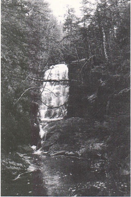
Later on at home, I did some research on the falls which any smart person would have done before trying to reach them! It was a surprise to see a photo looking nothing like what I had found. A little more digging here on VFTT revealed the location to be not too much further upstream from where I had been, so someday soon I'll have to return to complete this trip!
Beech Slapped and Hobbled - the failed second Galehead attempt and the Wrong Falls Adventure!
What a fine Tuesday! Unfortunately, circumstances occurred early in the morning that put a damper on my original plans in the Wild River valley, so at the late hour of 1 PM I was finally free and searching for something to take up a short afternoon. I finally settled tentatively on Galehead, since it is nearly in my backyard, and despite several visits to Galehead hut, I have never actually climbed the Frost trail to the summit. I have some crazy aversion to actually completing the 48 list.....
Ten minutes from home and I was at the Gale River trailhead. As I walked along the well-worn trail, my mind wandered a bit, recalling the history of the route. Back in 1954, a massive landslide necessitated the re-routing of this trail, which originally ran up a ravine further to the west, passing long lost Hawthorne Fall on its way up to the ridge. Somewhere up ahead was the turnoff for the old trail, just past the first crossing of Gale River and running up a western branch of the river to Hawthorne Falls. Perhaps I could go find it....
So, once again, Galehead was again thrown out the window (don't ask about the first time!) and new plans were made! Well, maybe I would do Galehead afterward....
With less than 2 miles to the first crossing, and an easy grade, the distance was covered quickly. The Gale River trail is extremely muddy, but not so much that a few rock hops wouldn't do the trick getting by. At the intersection with the river, a worn path appeared to continue straight ahead. I decided to follow that for a while and see where it led, since it was heading in the right direction.
The herd path followed the west side of the river for a while, slowly climbing the bank on the side as it got steeper and steeper. The river dropped further and further below, and the path finally seemed to peter out. I continued onward for a while through the tight scrubby trees. Just about the time I was about to head down the embankment and try to pick up the Gale River trail again, I spotted a pink ribbon tied to a tree. Then another one. This line of pink ribbons took me along a merry chase through the woods, up and down the embankment, before ending abruptly. I wondered again about people and their ribbon mazes in the middle of nowhere...
Cutting down the bank, I emerged on the edge of the western branch of the river. A few hops across and I was in the V between the two branches. A few moments later I came across an obvious old trail, complete with cut marks on branches and muddy footprints. The trail was well worn and easy to follow. Ahead, the woods got brighter and brighter, until the trail emerged into a large clearing on a huge slab of rock. The river streamed down the rock, falling over several cascades before settling into a pool at the bottom. Unless I was completely mistaken, this must be Hawthorne Falls!

The slabs above the falls were also beautiful, and I had a relaxing lunch. (Later, I realized that this was NOT Hawthorne Falls... oh well! Still, a very beautiful waterfall! Gives me something to check out again at a later date!)

Looking up, from the edge of the slab I could make out the cliffs of Flat Top Mountain over the trees. I could see several great perches right at the top, and it wasn't that far away. I decided to try and find the old slide that I had seen from photos from across the way. It wasn't very hard to find... at the top of the falls, the old slide comes down and almost touches the stream. At first, the slide was slippery slabs of rock, but there were enough handholds and branches that this was not a problem to navigate. Higher up, the slide switched between a rocky stream and wide open dunes of gravel.


In the largest gravel field, the cliffs above were easily visible and looked very close!

This was too easy! The slide got narrower and narrower, but was not difficult to scramble up, and seemed to be leading all the way to the top.
As usual, I realized I had spoken too soon when the slide came to an abrupt end a few hundred feet below the summit rocks. In front of me was an imposing, impossible-looking phalanx of blowdowns, dead spruce, and rocks. With great pain, I scraped, pulled, and heaved myself over, under, and through the mass, until finally emerging at the top, bleeding and bruised. The hard won view was worth it, though!
Galehead Hut in the saddle under South Twin

Garfield


Garfield

I sat for a while and relaxed in the sun, enjoying the beautiful panorama. Several hundred feet straight below, I could see the slide I had just climbed. The shining slabs of the falls were also visible through a break in the trees. I could see the windows of Galehead Hut with my binoculars. What a nice little perch!
All too soon, it was time to leave. Rather than attempt the horrible descent through the scrub and slide, I opted instead to head down the northern ridge and make it back to the trail. I took a NE bearing which according to the map would follow the ridge down and bring me back to the spot on the trail that crosses the Gale River. Along the descent, I found a few more viewpoints by poking around through the trees.
The way down was damp, with many rotting logs and blowdowns, tons of hobblebush and "sons of beeches", all attempting to untie my boot laces and knock me down. About half way down the slope, I crossed a few open areas that looked like old logging roads. These I followed for a short while, but they were heading in the wrong direction. In a tree near one of these "roads" was an old oil can. There must be a story here somewhere!

Despite all the adversity with the underbrush, the way down was fairly straightforward, and by following the ridge I came out of the woods about 100 feet from where I had started the bushwhack adventure.
Out of curiosity, I followed the Gale River trail upwards for a while, past the area where I had previously left it, to find the proper beginning of the old trail. After a few false starts, I found the trail and followed it up until I met the spot where I had discovered it a few hours earlier. The Waterfall/Flat Top Mountain loop was complete!
Later on at home, I did some research on the falls which any smart person would have done before trying to reach them! It was a surprise to see a photo looking nothing like what I had found. A little more digging here on VFTT revealed the location to be not too much further upstream from where I had been, so someday soon I'll have to return to complete this trip!
Last edited:


