GPS, Trails, Maps: A Plug for Wikiloc

vftt.org

Help Support vftt.org:

This site may earn a commission from merchant affiliate links, including eBay, Amazon, and others.

Paradox

New member
Joined
May 29, 2006
Messages
2,268
Reaction score
314
Location
Holderness, NH, Avatar: Pine Marten on Mt Field
Reading the recent thread on 60CSx vs. the Etrex I noticed the thread drift on the lack of maps available that include trails. I thought I would start a thread that was basically a plug for the "Wikiloc" website. It is an accumulation of GPS tracks & waypoints that you can download and manipulate on MapSource software. You can also upload your own GPS tracks. Photographs and trail descriptions can also be uploaded.

Here are some links to hikes I have taken: Davis Path in The Presidentials, Crockers in Maine, and the Dix Range in The Daks.
 
Last edited:
It's a useful site, and have been posting hikes to it as well - the link is here. Most of the hikes in my account are on the Left Coast. There's a track for Corkscrew in DV, which is a great hike but not the easiest one to find a good map for.

One feature I like of Wikiloc is it's ability to reduce the number of data points within the track. When you download it, the menu option gives you the ability to reduce the points to 500, which eliminates "Track Truncated" message you can sometimes get on the GPS.
 
I use Wikiloc as well and think it's a decent site. I have downloaded some of Paradox's tracks (accepting the disclaimer) for a few hikes that used bushwacks. I have uploaded about a dozen or so tracks as well to Wikiloc. I get an email from Wikiloc when someone has uploaded a track next to one of mine. It's kinda cool.

I have the Garmin 24K Northeast software on my Vista Hcx. All the trails are there, but I find "seeing" the trails on the GPS screen difficult as they are just light dashed lines. I prefer to either download a track from someone (and verify against the actual trail on Basecamp) or create my own track then download it to my GPS for the trail I intend on using. Tracks are much easier to see on the GPS sceen and you can change the color of the track as well.

Petch
 
Any risk/experience with downloading someone elses data that turned out to be inaccurate/off-course/purposefully deceptive ? I can see some yahoo out there thinking that would be funny.

Finally just got a 60csx for Christmas, so I'll need some instruction, and I know there's plenty of it here.
 
One feature I like of Wikiloc is it's ability to reduce the number of data points within the track. When you download it, the menu option gives you the ability to reduce the points to 500, which eliminates "Track Truncated" message you can sometimes get on the GPS.
The maximum saved track size in many (all?) Garmin GPSes is 500 (I think) points and if you save a track in the GPS it will be reduced to 500 points. Wikiloc is simply replicating this function to stay within the device limits.

Doug
 
The maximum saved track size in many (all?) Garmin GPSes is 500 (I think) points and if you save a track in the GPS it will be reduced to 500 points. Wikiloc is simply replicating this function to stay within the device limits.

Doug

FWIW - I don't save tracks to the GPS itself. Rather, I download them from my GPS after each hike, "clean them up" as necessary, and then save them to my hard drive. If I want to re-use them, I download them to my GPS prior to the hike. There's a useful thread from a few months back, with a tip about naming the track to "ACTIVE LOG 001", and turning off the GPS function before the download. Probably a few other pointers in there as well, but those two were particularly useful to me.

This may sound elitist, but ... this is a hiking BB, and as such my primary interest re: GPS are those made by Garmin, and considered "mapping GPS's". Primarily those models are the HCx, the 60CSx (now 62 series), the 72 and some high-end units.
 
Why delete the tracks and keep them in the PC? Aren't they of better use inside the GPS (in the memory card). I keep all of mine inside the memory and I have found it useful to call up tracks made in the non-winter for use in the winter.

I will also memorize nice potential camping spots, water sources on dry routes like Tongue Mountain Range, trail junctions, eagle nesting sites, parking, and kayak launch sites etc

I still have yet to find a good way to name the various files...but I figure that if I really need to find the information then I will have time to scroll around.
 
Any risk/experience with downloading someone elses data that turned out to be inaccurate/off-course/purposefully deceptive ? I can see some yahoo out there thinking that would be funny.

Well the typical quad may have outdated information such as shelters that no longer exist or trails locations that have been moved. Or a map from a conservation group may indicate parking where there is none due to new ordinances or policy changes. Even a marine map doesn't show sunk, damaged, or moved navigational aids.

Of course such discrepancies are not purposeful, but you are always taking chances if you do not get two independent sources of information.

At the very least the free maps from WikiLoc should be able to be rated by people.
 
The maximum saved track size in many (all?) Garmin GPSes is 500 (I think) points and if you save a track in the GPS it will be reduced to 500 points. Wikiloc is simply replicating this function to stay within the device limits.
The reason for this comment is to explain why Wikiloc can shrink a track to 500 points--so it can be loaded back into a GPS as a saved track.

FWIW - I don't save tracks to the GPS itself. Rather, I download them from my GPS after each hike, "clean them up" as necessary, and then save them to my hard drive. If I want to re-use them, I download them to my GPS prior to the hike. There's a useful thread from a few months back, with a tip about naming the track to "ACTIVE LOG 001", and turning off the GPS function before the download. Probably a few other pointers in there as well, but those two were particularly useful to me.
I have never loaded a track back into a GPS and rarely save them in the GPS. I often don't even bother to download them either. We each use our GPSes for what we want.

This may sound elitist, but ... this is a hiking BB, and as such my primary interest re: GPS are those made by Garmin, and considered "mapping GPS's". Primarily those models are the HCx, the 60CSx (now 62 series), the 72 and some high-end units.
Huh? Elitist? Since hikers frequently use and rely on GPSes, then any info which helps them to use them is, IMO, appropriate.

Doug
 
Why delete the tracks and keep them in the PC? Aren't they of better use inside the GPS (in the memory card).

I do it for several reasons - the first being the GPS has a finite amount of memory, whereas the PC does not (for all practical purposes).

I nearly always reload a track on a return visit, so will edit any waypoints I may have created on the first hike. For example, I typically set a waypoint at the beginning of the hike to mark the location of my truck (many of the peaks I hike in the west are trail-less) so the initial waypoint of "001" I edit to "P" and use an appropriate symbol, and edit/add/delete other waypoints during this review process. On an "out and back" hike it's not necessary to have "double track", so I can edit out one direction. I often organize hikes, and so can attach a map showing the route - the list goes on and on.

I don't keep the GPS track of every hike I do, as I typically do 75-100 hikes a year. I do keep the best track for each hike, however. And sometimes that means there's a summer variation and a winter variation.

Am not suggesting my way is the best way - not at all. It's simply what works for me, and am always interesting in hearing how others use this most useful device.
 
Apologies if I sounded critical....I think there will be plenty of memory if you archive stuff to the memory card and not the onboard flash memory.

I have grown weary of hooking stuff up to the pc to get complete functionality. Just tonight I plugged a microphone into the front microphone jack on my PC and Windows 7 gave me a little questionaire to fill out--did I just plug in front speakers, rear speakers, line in, line out...etc.

Its not getting any better.

Instead I just remove the card from the GPS, plug it into a card reader, copy the card to the PC, and plug it back into the GPS. Most software can import tracks from the files on the PC.
 
Apologies if I sounded critical....I think there will be plenty of memory if you archive stuff to the memory card and not the onboard flash memory.

Instead I just remove the card from the GPS, plug it into a card reader, copy the card to the PC, and plug it back into the GPS. Most software can import tracks from the files on the PC.
One cannot get access to all of the data in the GPS without plugging it into a computer. The 60CSx (many other Garmins are similar) stores the tracklog, saved tracks, waypoints, and routes in internal memory. It will not read any of the above from a memory card. To read or write the data stored internally, one must use a direct connection to a computer.

The memory card stores the map file which can be read or written directly from the computer. The 60CSx can optionally write a copy of the tracklog to the memory card in the form of daily logs which can also be read by a computer. (However, the 60CSx will not read the daily logs so one cannot send data to the GPS by this route.)

Some people are also concerned about contact wear from frequent card removal and insertion.

Doug
 
Last edited:
Switzerland

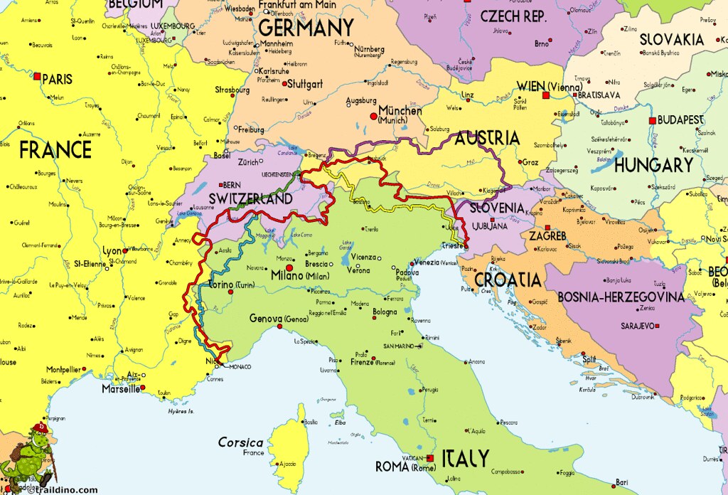
This probably the 'wrong side of the pond' to ask this question but I am planning a 15 day trek through Swiss Alps next year and was wondering if anyone knows a good source for trail maps that would work on my Garmin 60csx?
 
The memory card stores the map file which can be read or written directly from the computer. The 60CSx can optionally write a copy of the tracklog to the memory card in the form of daily logs which can also be read by a computer. (However, the 60CSx will not read the daily logs so one cannot send data to the GPS by this route.)

Doug

What's the recommended setting for wrapping the track log when full? If I have it recording to the card as well, do I want it to wrap?

It appears that if the "wrap when full" option is checked, the full log continues on the card, and the one in the GPS is wrapped. When it is not checked, it's not clear if the card log continues when the in-memory one stops.

I find it unfortunate that you cannot use the card for loading tracks :(

Thanks,
Tim
 
This probably the 'wrong side of the pond' to ask this question ...
Not really :)

You have two options. The free option is to use the OSM-based map (use Google Translate if, like me, you do not read German). It has contours, roads and a growing number of hiking trails, but is definitely a work in progress. That is what I used this past summer.

The commercial option is the Swiss Garmin map, which you can buy for either the East or the West half of the country (or, obviously, both). It is not cheap (small market), description here in French or German.

I believe that the Garmin.ch site does not sell maps directly; Google will lead you to a vendor.

Where are you planning to hike this summer? If you are planning on doing part or all of the Haute Route check my site: Haute Route (shameless plug :D).

[Added]What the heck, why not also put in a plug for my blog: Hiking in New Hampshire and Switzerland ?[/Added]
 
Last edited:
What's the recommended setting for wrapping the track log when full? If I have it recording to the card as well, do I want it to wrap?
The tracklog is 10K points long (settable?), I always set it to "wrap when full". That way I always have the latest 10K points. (You can set the tracklog display to display fewer than 10K points if you wish. IIRC, mine is set to 3K (default?).)

It appears that if the "wrap when full" option is checked, the full log continues on the card, and the one in the GPS is wrapped. When it is not checked, it's not clear if the card log continues when the in-memory one stops.
I always figured that the internal and external (memory card) track logs were independent, but I have never experimented with recording to the card. (I'll probably use it on my next big trip out west or something similar.) I believe at least one other forum member uses it regularly--I'll let him speak up for himself if he so chooses.

I find it unfortunate that you cannot use the card for loading tracks :(
The current functionality is consistent with the earlier units without memory cards. The record-track-to-card feature can be viewed as an add-on. And of course, there is the trade-off between complexity and usability...

BTW, it occurred to me that a disadvantage to loading a guide track to the active track log is that the loaded track will be flushed from the tracklog as you record more tracklog (unless you turn tracklog recording off). A better solution would be to load the guide track to a saved track--that way it will not be flushed by recording new tracklog.

Note: Garmin GPSes flush the timestamps from saved tracks and will also remove the timestamps from any externally loaded tracks. (GPS tracks are used to score some sporting events and this prevents forging a track.)

Doug
 
Nice web site. I will have to study your route carefully.

Right now my plan is to hike the Green Route of the Via Alpina
5091523745_177b6f46c2_b.jpg
 
...Note: Garmin GPSes flush the timestamps from saved tracks and will also remove the timestamps from any externally loaded tracks. (GPS tracks are used to score some sporting events and this prevents forging a track.)

Doug

Hmm... are you sure of this? Perhaps it matters where the track is saved - GPS or PC. If I download the tracks to my PC after a hike, edit/clean them up if necessary, save them and then pull them back up in MapSource - the date and timestamp for each point within the track remains. Then, if I download that track to my 60CSx, and then upload it again - nothing will have changed.

Are we comparing apples and apples here?
 
Hmm... are you sure of this? Perhaps it matters where the track is saved - GPS or PC. If I download the tracks to my PC after a hike, edit/clean them up if necessary, save them and then pull them back up in MapSource - the date and timestamp for each point within the track remains.
It has been reported that the timestamps are flushed when track is loaded into the GPS.

Then, if I download that track to my 60CSx, and then upload it again - nothing will have changed.
Have you actually tried this? (computer (trk1) -> GPS (trk2) -> computer (trk3))

My reports indicated that timestamps in trk1 will be absent in trk2 and trk3. Haven't actually tried it myself. (We do know that any timestamps in trk2 will be in trk3.)

Note: Unfortunately the words upload and download are ambiguous and confusing...

Doug
 
Top