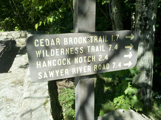
Hancock Notch Trail / Trail Head ?

vftt.org

Help Support vftt.org:

This site may earn a commission from merchant affiliate links, including eBay, Amazon, and others.

JustJoe

Active member
Joined
Mar 10, 2010
Messages
690
Reaction score
51
Location
Ipswich, Ma.
I did the Hancocks Saturday and saw this for the first time. This is actually a swinging gate and the signs are gone. I was just curious if anyone knows why. The gate implies to me that possibly someone got hit by a car crossing the Kanc. Not sure why they would have removed the signs unless they were stolen.

My last time there was last March.

PA220001.JPG

The%2525252520Huntingtons%2525252520002.jpg
 
But seriously....

Wasn't there a problem with the beginning of that trail after Irene passed through?

A couple of weeks ago, on a Sunday night at dusk, we were heading west to east and saw where a motorcycle had just gone down on the hairpin. People were there helping direct traffic and comfort at least one rider/driver, but the rescue team didn't arrive for at least another ten minutes. It is a bad turn and not a good place for a trailhead to be located.
 
A couple of weeks ago, on a Sunday night at dusk, we were heading west to east and saw where a motorcycle had just gone down on the hairpin. People were there helping direct traffic and comfort at least one rider/driver, but the rescue team didn't arrive for at least another ten minutes. It is a bad turn and not a good place for a trailhead to be located.

Absolutely, having the trail cross right at the turn is just asking for trouble. I'd say many people driving through for the first time have trouble just making it around safely, obviously more so going down hill. It only is easy for people walking straight across and finding the spot on the map.

It seems the best way would be to have the trail start across from the road entrance of the parking lot and then have a short new section of trail run along the road. It would add less or about .1 of a mile at best. This would make it so that cars coming down the road had a better line of site to people crossing and a flatter section of road to do the stopping on.

Even if you got crazy and built an over the road crosswalk over the road at the hairpin creating a safer option for hikers you would be creating a distraction at the most dangerous point taking the attention away from drivers at the time they should be totally focused on the road.
 
No doubt the crossing and layout are hazardous, but it's worth noting the historical origins: When the Kanc was extended/built from Lincoln towards Conway, it followed the old railroad bed most of the way to the current Hancock Notch trail. At that point the new road turned away from the RR grade, creating the hairpin turn we know today, and the access to the Hancock Notch was effectively established where the two routes diverge. Believe it or not, it's not that long since the trail parking was on the shoulder of the highway, at the west end of the hairpin!
 
Hmm... The sign was there July 10, that was the last time I was in the area *itisstillamystery*...

IMG_20110710_093754.jpg
 
I'm a history buff and cherish many of the old bi-ways.

Many who know me know won't believe it, but day was when I would seek out abandonded roads for riding my off-road/road legal motorcycle. In the early 70s I was one of the original organizers of the Amonoosuc River Trail Ride, a 100-mile Turkey Run for members of the New England Trail Rider Association. I loved looking at maps and figuring out how to string a day-long ride using as many trails and old roads as possible for this ride and for personal pleausre. Because of this, my eye has been trained to spot the old route many times. I'm a hiker now, but my eyes still see the potential routes that challenged me then.

Back to the hairpin turn, trailhead, parking area on the Kanc. Remember when the parking lot wasn't where it is now but was located across the road, up on the hill?

Times change for safety sake and this hairy turn, along with the trailhead being right at the bend, is one that I see fits into that category.

I wonder if some rumble strips would help drivers understand the danger that lies ahead of them in that section of road?
 
Accident waiting to happen

I got to agree with ColdRiverRun. That trailhead on the hairpin turn is/was and accident waiting to happen. Much better if the traihead was relocated up the road a short piece.
 
Look Both Ways Before You Cross

Even if you got crazy and built an over the road crosswalk over the road at the hairpin creating a safer option for hikers you would be creating a distraction at the most dangerous point taking the attention away from drivers at the time they should be totally focused on the road.
I got to agree with ColdRiverRun. That trailhead on the hairpin turn is/was and accident waiting to happen. Much better if the traihead was relocated up the road a short piece.
They'll probably just end up closing the trail permanently.

How many years has that trailhead been there and how many hikers have been hit by a car there? My guess is zero. It's pretty easy to "look both ways" and cross the street...

-Mr. Kill
 
Last edited:
Is this really a problem that needs fixing? You're probably more likely to be injured driving TO the trailhead than crossing the Kanc.

I've crossed there many times and have never even come close to being injured/killed. Gimme a break, just cross the road!

Edit: And what Wu said!!

PS - The sign is stupid, too. "Highway crossing." DUH, PEOPLE!!! ha
 
Last edited:
Ed - you are right about that! I never liked riding across railroad tracks that were diagonal. But rumble strips could be placed well in advance of the turn on either side, just as they are at toll booths.

(I have to admit to my friends here that sometimes I ride along the rumble strip on the roadsides just because I get a kick out of the rumble. And at toll booths, too, but I do try to stay where I'm supposed to be. Outside of where I work there are bricks on the roadway to indicate crosswalks. Now they are worn down and don't make a rumble sound, but I always liked it when they did and I'm disappointed now and think they should be replaced for my personal pleasure.)
 
How many years has that trailhead been there and how many hikers have been hit by a car there? My guess is zero. It's pretty easy to "look both ways" and cross the street...

-Mr. Kill

What would of been your guess on the number of accidents there in general? If you hadn't just read in the thread about someone stating how a motorcycle went down would you have known? I don't think it is as much about the danger for hikers but the people driving around the turn instead who might have to make maneuvers to avoid hikers that create a risk.

The sign with the simple statement, "Caution - Highway Crossing" is poor for sure. But, lets keep in mind the vast majority of people stopping at the parking lot all day are tourist looking to get out and take pictures and such, not hikers bagging the Hancocks. If it read, "Caution - Leads to High Crossing" it would sound more proper and give direction but the shorter, "Caution -Highway Crossing" gives the same information. Human Behavioral science has shown that you want the simplest direct form in all safety situations. An example is you could have signs that say things like, "leads to exit" but simply stating "EXIT" is far more direct and effecient.
 
Wasn't there a problem with the beginning of that trail after Irene passed through?
s a bad turn and not a good place for a trailhead to be located.
Yes, but it was fixed very quickly

It seems the best way would be to have the trail start across from the road entrance of the parking lot and then have a short new section of trail run along the road. It would add less or about .1 of a mile at best. This would make it so that cars coming down the road had a better line of site to people crossing and a flatter section of road to do the stopping on.
The FS actually proposed building a culvert/underpass, I asked who would shovel it out for the skiers and that was the end of that

If you look more closely at the road passing the parking area, it is in a ledge cut so to make the trail go straight across you would need a ladder or to blast out a staircase which would not be cheap plus hikers would bunch up in the road waiting to go up. Then you need to go up over the ridge and down to the trail. Skiers of course would still use the old trail when the crossing is between snowbanks and even more hazardous.

There is no easy fix, the way it is will have to do.
 
Human Behavioral science has shown that you want the simplest direct form in all safety situations. An example is you could have signs that say things like, "leads to exit" but simply stating "EXIT" is far more direct and effecient.

That's the premise of calling "Rock" when you are climbing and something tumbles down. It could be your trail mix, water bottle or a real rock or chunk of ice. Keeping it simple makes it easier to understand.

This summer I screamed "NO!" to my dear three-year old granddaughter Emily. She had climbed into her daddy's car because the doors were open (because he was trying to air out the wet interior after windows were left open). As she began to close the door behind her, I saw her precious little hand on the door frame about to be crushed. No explanations needed. Keep it simple worked best. She understood NO. She knew that her gramE didn't ever talk to her in that tone of voice. She crumpled into a tight little ball on the driver's seat, hands, feet, face, and all. Simply safe. That's all.
 
was out there today doing trail work and while working the early stretch of the trail could hear squealing tires hitting the curve. pretty typical in my experience. i'll inquire about the trailhead sign. have been curious myself.

bryan
 
To be honest, we actually had a problem crossing at the end of the hike. I first looked up (east) then down (west and it was clear. But in those couple seconds, An SUV just appeared from the east as we stepped out. He didn't have to slam the brakes but it was a pretty abrupt stop. He came to a complete stop and told us to go but I waved him on for 2 reasons. One there was now a car coming from the west and I didn't want him to get rear-ended. He insisted on sitting there until we could cross.

Here's another question though. We are now warned about the highway crossing but does anyone know if there are pedestrian crossing signs in both directions warning drivers of us? I don't remember seeing those there.
 
Last edited:
If you look more closely at the road passing the parking area, it is in a ledge cut so to make the trail go straight across you would need a ladder or to blast out a staircase which would not be cheap plus hikers would bunch up in the road waiting to go up.

I thought that too, Roy. But after double checking on Google street view, the woods directly across from the entrance look suitable for a trailhead. The ledges, being further toward the hairpin. However, I still think $ could be better spent elsewhere.
 
Last edited:
Top