Hiker missing in NH Whites - Unfortunate ending (Claire Marie Cocuzzo)

vftt.org

Help Support vftt.org:

This site may earn a commission from merchant affiliate links, including eBay, Amazon, and others.
She would have likely stopped at Galehead Hut both out and back -- surely someone saw her there. Hope she is found soon, thankfully the weather has been good!

On the 10th, there were over 90 people at Guyot campsite (hearsay from some hikers who talked to the caretaker), and plenty of people camping on any flat spot beside the Bondcliff trail and the West Bond spur. It is hard to believe she would not be spotted if she was in the area. People I spoke to were coming and going from Guyot Campsite from LW, Zealand and the Twins...even a guy who bushwhacked up Hellgate Ravine to West Bond.

Spread the word.
 
Garfield trail to Bondcliff and back in five nights? Either she spent three nights camping at Guyot, or the description of her itinerary is incomplete. Maybe she planned to 'whack down Hellgate brook and loop to 13 Falls, for example. That would make her considerably harder to find.

(F&G is surely not giving us all the details they know. Did she drive herself to the trailhead? Is her car still there?)
edit for clarity:

For a simple ridgetop out-and-back I would assume first and last nights at either Garfield or Galehead, one or two nights at Guyot. Maybe Garf -Guyot-Guyot-Galehead. I wouldn't know what to do with a fifth night unless I had a side trip in mind.
 
Last edited:
That time period includes Friday the 9th through Saturday AM. A front came through that night and there was heavy rain followed by wet cold conditions with snow down to 2000 feet. In the AM it was at or below freezing. The sun came out by mid day (I was hiking Thoreau Falls trail) and it was hypothermia conditions in the AM.
 
yes - conditions were VERY wintry into Saturday morning in that area - I was surprised how slippery things were above 3K feet. I find it hard to believe, if she were on-trail, that someone would not have found her if she had a problem - there were SO MANY hikers in that area.
 
Garfield trail to Bondcliff and back in five nights? Either she spent three nights camping at Guyot, or the description of her itinerary is incomplete. Maybe she planned to 'whack down Hellgate brook and loop to 13 Falls, for example. That would make her considerably harder to find.

(F&G is surely not giving us all the details they know. Did she drive herself to the trailhead? Is her car still there?)

She could have planned on spending the first and last night at Garfield Ridge Shelter. With a 5 day hike planned, I doubt she planned that many miles in the first and last day to get from the trail head to Guyot.

I certainly agree though that more info would be useful. If nothing else, maybe what color shirt/jacket/pack she was likely to be wearing.
 
Unfortunately, word is she has been found deceased in a stream bed.
 
Last edited:
'Two miles from Galehead hut, at a crossing of the Gale River.' Must be on the Gale river trail (I know news said Garfield to Bonds, but she may have come in on Gale River trail, tagged Garfield and then doubled back a short ways and headed out towards the Bonds, then was on her way back to the trailhead when she fell in the river - or any number of other plausible scenarios). There's a tributary that feeds into the N. Branch of the Gale River about 2 miles from Galehead hut on the Gale River trail. It has been a while since I've been out that way, so I can't recall if this crossing is problematic. But I'm guessing that's where we're talking about. There are no river crossings on the Garfield Trail within ~2 miles of Galehead hut.

As chance would have it, I'm heading up to Galehead hut tomorrow. I'll certainly be paying my respects in whatever way feels appropriate as I pass by. I am terribly saddened to hear about this and wish her family and friends peace.
 
Sorry to hear the results.

The discussion regarding unexpected river crossings is interesting. During a Thoreau Falls trail trip on Saturday we ended up having to make a detour and a bushwhack around the upper crossing of the North Branch to avoid a dangerous crossing due to high water and spent some time at the site of the proposed bridge removal on the south end which also was unsafe to cross due to high water caused by an overnight storm. We even discussed that sometimes a hiker decides they have no choice and take a chance and although most of the time they make some don't. Unfortunately it looks like the case on this one.
 
so sad.....

I'm confused about the location: the reroute of 2011 eliminated the (2 big) crossings of the Gale River. Of course, the old trail (if followed) *does* cross it twice. The Garfield Stream (at 2.2 miles up the trail) is fairly minor - a rock-hop with (as I recall) no large pools. I was on the Gale River Trail (the re-routed, current trail) last Saturday and cannot figure out where this happened. Hopefully more info will be forthcoming to help prevent similar situations. :(
 
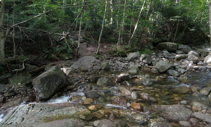
Tragic. My heart goes out to her family. Since the dates in the different stories are different, there's no telling what day she may have made that crossing. The heavy rain was on the 9th I believe. This is the crossing of Garfield Stream at the end of the re-route. It dumps into the Gale River about 500' from this crossing. A gentle flow here but I can see it getting real bad there after a heavy rain. Coupled with a pack weight for 5 nights. Very tragic.

P8120010.JPG
 
yes JustJoe - that's approximately how the stream looked last Saturday morning (Oct 10) after a lot of rain. You're picture gives a good idea of how the Garfield Stream flows. VERY different from the Gale River which I didn't cross or see, but, I am sure was roaring.

The elevation of the Garfield Stream crossing there is about 2200'. I found slippery snow in the woods (I was bushwhacking up Garfield Stream) at about 3000'.
 
Last edited:
Tragic. My heart goes out to her family. Since the dates in the different stories are different, there's no telling what day she may have made that crossing. The heavy rain was on the 9th I believe. This is the crossing of Garfield Stream at the end of the re-route. It dumps into the Gale River about 500' from this crossing. A gentle flow here but I can see it getting real bad there after a heavy rain. Coupled with a pack weight for 5 nights. Very tragic.

P8120010.JPG

This is the only real crossing left on Gale River Trail now post reroute (and as usual Joe has the exact right photo for the thread). I wouldn't have expected it to be dangerous unless the water was very high but as Joe pointed out with a 5 day overnight pack, and she could well have already been fatigued, possibly hypothermic or whatever which magnified the risk of the crossing. A soaking wet packet on a tired 130 lb woman would be a hell of a burden to shed in swift moving water. I assume if she was that far down this trail given the itinerary they provided she was bailing out not hiking as planned and may have been desperate to get out of the woods. That crossing is well off the ridge and the GRT.
 
I'm confused about the location: the reroute of 2011 eliminated the (2 big) crossings of the Gale River. Of course, the old trail (if followed) *does* cross it twice. The Garfield Stream (at 2.2 miles up the trail) is fairly minor - a rock-hop with (as I recall) no large pools. I was on the Gale River Trail (the re-routed, current trail) last Saturday and cannot figure out where this happened. Hopefully more info will be forthcoming to help prevent similar situations. :(

It's possible that whatever happened didn't happen at a crossing. Above where the old and new routes rejoin is an outlook with a view eastward across the ravine to the Twins. Right at the edge of the trail at that point is a steep, 50+ foot drop to the stream.
 
Many of the previous posts have focused on the Gale River trail which follows the North Branch of the Gale River.

However, her stated route was the Garfield Trail which crosses 2 tributaries (Thompson and Spruce Brooks) of the South Branch of the Gale River* **. (The above linked accident reports do not say where she was found on the Gale River system.) It is conceivable that she was swept away while attempting to cross either of these brooks.

* The old routing of the trail also used to cross the South Branch a short distance S of the Gale River Loop Road where there is a substantial flow. The current routing of the trail does not use this crossing, however one could stumble into it on the descent after missing a turn.

** These crossings are avoidable by a short bushwack, a stream crossing on a snowmobile bridge (Heritage Trail), and another short bushwack.

Doug
 
Top