
1HappyHiker
Well-known member
Dunno, probably it’s just me who sometimes gets what I’ll call “Hiker’s Guilt”. I’m talking about hiking to a particular spot and knowing that another summit is close-by in the same area, and then feeling guilty if you don’t go to that other destination as well. You know, you’re already close, so why not go? On my 23-August trek to East Royce, I had a case of “Hiker’s Guilt” about West Royce.
East Royce is a summit that many hiking friends have highly recommended to me. And so, for quite awhile it’s been on my list of places to visit. West Royce is very close by, plus it’s on the NH 52 With-a-View list. And so, since I would already be in the vicinity, I felt I should pay a visit to this summit as well. BUT, for whatever reason, I was finding it difficult to work up enthusiasm about adding West Royce to my trek.
In about 55 minutes, I made it to the more frequently visited “tourist summit” of East Royce where the official trail ends. I took a few snapshots, and then headed directly to the northern knob where I was told the views are better. The less-visited northern knob of East Royce is reached via a herd path, and this took maybe another 10 minutes to trek over there. And so, I’m now just a bit over an hour into my journey, and there’s still plenty of time to visit West Royce.
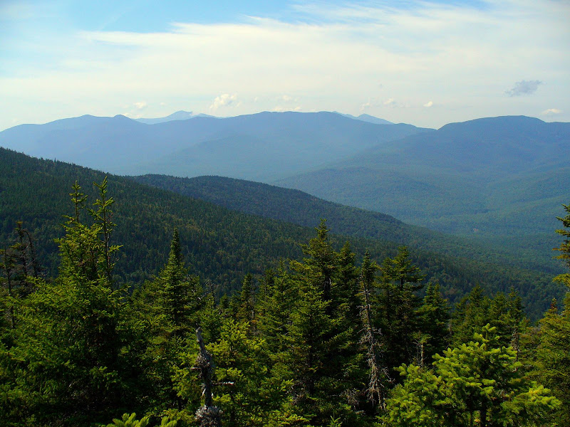
The views from the northern knob of East Royce are indeed very nice! Particularly nice is the view to the west looking over the Wild River Wilderness at the Carter Range with tops of the Presidential Range on the horizon, as shown in the photo below.
I lingered there on the northern knob of East Royce for close to an hour eating a leisurely lunch, and soaking in the views (and the sunshine!). And then “Hiker’s Guilt” began to grab me about trekking on over to West Royce. So, I packed up my things and trekked the short distance back to the “tourist’s summit”. Once I arrived there, I pulled out the map and calculated it would involve an additional round-trip mileage of 3.7 miles to add West Royce to my trek. Hmmm! With the amount of time still available to me, I wondered if it was still doable (or was I just looking for excuses not to go there?!).
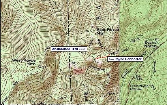
While calculating the mileage to West Royce, I remembered that a friend had told me that there was once a trail that came off the summit are of East Royce that headed in a southwestwardly direction toward the Royce Trail. Below is an old map which shows this old trail. (The present-day Royce Connector Trail is hand-drawn in red.)
Hey! I thought maybe I could find this old trail and save myself some time. And besides, this would really be fun!! (Or, was I still just looking for an excuse to do something other than go to West Royce??)
So, I was now on a mission to find the old trail off the summit area of East Royce. I explored several false leads (all of which ate up scuds of time). But finally I found a faint path that showed some promise. I checked my compass and it was heading in the right direction, and I checked my GPS and it showed that from where I was standing, it was only about 0.2 mile to the Royce Trail. So, I was off on my fun adventure!
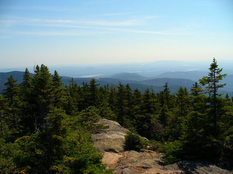
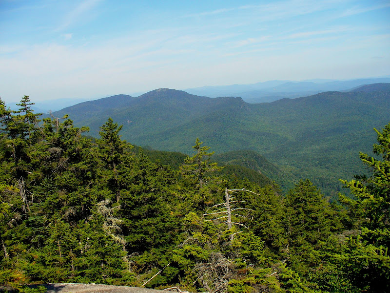
About 5 minutes into my “fun adventure” I came upon a ledge that had some fine views to the east toward Kezar Lake and Mt. Caribou. It was a very comfortable ledge for lingering, and so I did! Below are a couple of photos from that ledge, and below these photos, my tale continues!
Eventually “Hiker’s Guilt” came around. So I decided to get up from my comfortable ledge and continue following what I think was the old trail. Several times I lost all trace of the “trail”, but it was easy whacking despite the very steep terrain, and I just continued on the same bearing. The total whack time from the East Royce summit to the Royce Trail was only 20 to 30 minutes (not counting the time spent lingering on the comfortable ledge along the way!).
OK! Now I was on the Royce Trail and it was decision time . . . go to West Royce, or not? I decided NOT!! I had managed to fritter away enough time that now it would really be pushing it to go over there. And besides I thought, I definitely wouldn’t have enough time to enjoy the views once I got there. (Or was I still just looking for excuses not to go to West Royce today?!)
THE BOTTOM-LINE TO ALL THIS: I really enjoyed the hike up to East Royce and the views from there are fabulous. Those who recommended it to me were right! Also, it was great fun exploring what might have been the old trail that went SW off the summit area of East Royce.
And oh yes! I will eventually get to West Royce, but today just was not the day!!
1HappyHiker
East Royce is a summit that many hiking friends have highly recommended to me. And so, for quite awhile it’s been on my list of places to visit. West Royce is very close by, plus it’s on the NH 52 With-a-View list. And so, since I would already be in the vicinity, I felt I should pay a visit to this summit as well. BUT, for whatever reason, I was finding it difficult to work up enthusiasm about adding West Royce to my trek.
In about 55 minutes, I made it to the more frequently visited “tourist summit” of East Royce where the official trail ends. I took a few snapshots, and then headed directly to the northern knob where I was told the views are better. The less-visited northern knob of East Royce is reached via a herd path, and this took maybe another 10 minutes to trek over there. And so, I’m now just a bit over an hour into my journey, and there’s still plenty of time to visit West Royce.
The views from the northern knob of East Royce are indeed very nice! Particularly nice is the view to the west looking over the Wild River Wilderness at the Carter Range with tops of the Presidential Range on the horizon, as shown in the photo below.
I lingered there on the northern knob of East Royce for close to an hour eating a leisurely lunch, and soaking in the views (and the sunshine!). And then “Hiker’s Guilt” began to grab me about trekking on over to West Royce. So, I packed up my things and trekked the short distance back to the “tourist’s summit”. Once I arrived there, I pulled out the map and calculated it would involve an additional round-trip mileage of 3.7 miles to add West Royce to my trek. Hmmm! With the amount of time still available to me, I wondered if it was still doable (or was I just looking for excuses not to go there?!).
While calculating the mileage to West Royce, I remembered that a friend had told me that there was once a trail that came off the summit are of East Royce that headed in a southwestwardly direction toward the Royce Trail. Below is an old map which shows this old trail. (The present-day Royce Connector Trail is hand-drawn in red.)
Hey! I thought maybe I could find this old trail and save myself some time. And besides, this would really be fun!! (Or, was I still just looking for an excuse to do something other than go to West Royce??)
So, I was now on a mission to find the old trail off the summit area of East Royce. I explored several false leads (all of which ate up scuds of time). But finally I found a faint path that showed some promise. I checked my compass and it was heading in the right direction, and I checked my GPS and it showed that from where I was standing, it was only about 0.2 mile to the Royce Trail. So, I was off on my fun adventure!
About 5 minutes into my “fun adventure” I came upon a ledge that had some fine views to the east toward Kezar Lake and Mt. Caribou. It was a very comfortable ledge for lingering, and so I did! Below are a couple of photos from that ledge, and below these photos, my tale continues!
Eventually “Hiker’s Guilt” came around. So I decided to get up from my comfortable ledge and continue following what I think was the old trail. Several times I lost all trace of the “trail”, but it was easy whacking despite the very steep terrain, and I just continued on the same bearing. The total whack time from the East Royce summit to the Royce Trail was only 20 to 30 minutes (not counting the time spent lingering on the comfortable ledge along the way!).
OK! Now I was on the Royce Trail and it was decision time . . . go to West Royce, or not? I decided NOT!! I had managed to fritter away enough time that now it would really be pushing it to go over there. And besides I thought, I definitely wouldn’t have enough time to enjoy the views once I got there. (Or was I still just looking for excuses not to go to West Royce today?!)
THE BOTTOM-LINE TO ALL THIS: I really enjoyed the hike up to East Royce and the views from there are fabulous. Those who recommended it to me were right! Also, it was great fun exploring what might have been the old trail that went SW off the summit area of East Royce.
And oh yes! I will eventually get to West Royce, but today just was not the day!!
1HappyHiker
")