Mahoosuc Trail to Mount Hayes

vftt.org

Help Support vftt.org:

This site may earn a commission from merchant affiliate links, including eBay, Amazon, and others.

yvon

Active member
Joined
Mar 11, 2005
Messages
872
Reaction score
154
Location
Montreal, Quebec, Canada
Does anyone know if the trail was been broken recently, or have recent informations, for the Mahoosuc Trail to Mount Hayes from road # 16?
The most recent information I found is on December 8.
 
I havent been up there this winter but the area gets a lot of use. Unless you need that section of Mahoosuc trail, its actually more convenient to climb from the Hogan road in Shelburne via the Centennial trail. There is a cabin that is used by mostly AMC managers off Hogan Road so that side gets more traffic. The summit is not marked and before you reach it, you cross the south summit then go back in the woods. If you go this way, its worth spending the time to head to the ledges via the Mahoousuc trail (back to Gorham).

If you do take the RT 16 approach, the first 1.5 miles until the turn off of Hogan Road is poorly marked. Basically cross the train trestle and climb up the steep slope to the snowmachine trail (former railroad bed), follow the old railroad bed until you cross the river again, take an immediate right turn after crossing the bridge and walk by an old car in the woods. Follow the path to the Hogan road next to the power lines (which is also a snowmachine trail) and follow the road downriver which runs parallel with the river. When you see a hydro dam in the river look left. There should be a AMC sign. If you walk past the hydro dam you have gone too far. Turn around and look for an old woods road that goes up into the woods. The short spur to Mascot Pond is worth the five minutes . About half way up the mountain you cross an obvious old woods road, if you take a right off the trail and walk about 100 feet, there is a steep slope to your right, climb up the slope and there is very good view. When you get back on the trail it runs through hardwoods then cuts into softwood before coming out on the best view. This is not the summit, the trail goes back into the softwoods and runs basically flat until a slight rise where you come out at the junction with the Centennial trail whihc is in the general area of the assumed summit.

Thank you,
Centenial Trail was my first choice. But on John Blog, he have wrote: I was equally surprised to see that the trailhead parking lot for the Centennial Trail had been plowed (next photo). However, the trail itself only had a few random animal tracks. There was no evidence of any human traffic.
That's why I am asking informations on the Mahoosuc Trail.
 
Peakbagger makes some very good points in favor of the Centennial Trail. Perhaps, like many things, it comes down to a matter of personal preference. I've done winter hikes to Mt. Hayes via both the Mahoosuc Trail (from Rt. 16), and the Centennial Trail. I prefer the Mahoosuc route since it more quickly gets you to the ledges just south of the summit. Also, I like having the option of stopping by Mascot Pond, and hiking to the ledges off the old woods road that Peakbagger mentioned.

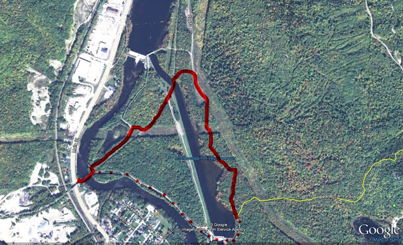
I agree with Peakbagger that it can be confusing to locate the Mahoosuc trailhead when using the Rt. 16 approach. However, if you look at the route from a Google Earth perspective, it is a bit more straightforward. Basically, just follow the route shown by the solid red line. (There is a verbal description of this route at the bottom of page 530 of the 29th edition of the White Mountain Guide.)

As a side note, your gut (or your GPS) is going to tell you to hang a sharp right after crossing the railroad bridge (see red dots on the map shown below). Although this would be a more direct route, I think that you can no longer cross the canal at the hydro dam. Perhaps Peakbagger can correct me if I'm wrong about that.

As one other side note, the Mahoosuc Trail (shown in yellow) is labeled as the Appalachian Trail by Google Earth. Oh well! :)
Mahoosuc.JPG


P.S. Thanks Peakbagger for your comment about there being a cabin off Hogan Road that is used by AMC managers. As I noted in my BLOG, I wondered why anyone would travel Hogan Road in the winter!
 
Last edited:
Peakbagger and 1HappyHiker both correct with directions and info...I prefer this route in winter as sometimes Hogan Rd. is not plowed from it's jct. with North Road and no one goes on the Centennial. The Mahoosuc seems to get a lot of traffic from Rt. 16 and it usually is a well packed trail up to that lookout that Peakbagger mentioned (take a right on the well defined logging road and another right you can't miss it on a clear day)..also Mascot Pond sits below Mascot Mine, which is a "batcave" used recently to test for white nose syndrome...hope you hike this on a nice day, the views of the Evan Notch area, Moriahs, Carters, Wildcats and N Presis and other surrounding peaks are great from the ledge...continue to the Centennial Jct. for further views of Cabot Weeks etc and Percys in N NH!! and the Mahoosuc was once the AT at this point until the Centennial was built...
 
I can confirm that hikers can not hike over the dam anymore. I expect someone could argue this as it was openly used by the public since the construction to when Brookfield purchased the facility and set up fences to block hiker traffic. The walk over the dam was interesting as you could look into the turbines bays. I expect that Homeland Security rules for protecting vital infrastructure negates the public rights but that is another day discussion. The Brookfield folks grew tired of hikers coming to the dam looking for a way to cross and did erect some yellow signs redirecting hikers to the railroad bed. Unfortunately they didnt erect signs once a hiker crossed over the power canal bridge so it was up to the hiker to guess that they had to walk a considerable distance downriver to get to the trail. There is an obvious shortcut from the power line to the Mahoosuc trail but reportedly due to the number of landowners that would require to agree to a relocation, this hasnt occurred. For several years the AMC for quite awhile discontinued the official trail once it turned on the road near the power house.

By the way there is limited info on the web about the AMC cabin off Hogan road. It not publicized and is run be a "separate" group from AMC but has significant ties. THis link mentions it.

http://www.library.unh.edu/special/index.php/amc-trail-crew-association-papers#bio
 
Last edited:
The Mahoosuc Trail to Mount Hayes trail is broken now. I did it with Annie. It was half broken till the Pond. We did it after to the summit and the Centenial Trail. The snow stick on the snowshoes. TR to follow.
The directions was perfect. Thank you guys. :)
 
Top