Mahoosuc trailhead in Gorham, question

vftt.org

Help Support vftt.org:

This site may earn a commission from merchant affiliate links, including eBay, Amazon, and others.

ferrisjrf

New member
Joined
Apr 2, 2008
Messages
189
Reaction score
242
Anyone have any recent beta on the current situation at the Gorham terminus of the Mahoosuc Trail?

This thread from November is the last info I've got. I assume the trestle being discussed is located at 44.402499, -71.198637

I guess my specific questions are: Where the hell do you park, and what do you do after you walk across the trestle (i.e., is it still the same as peakbagger described?).

Jason
 
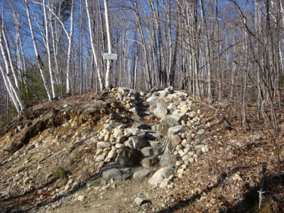
I hiked Mt. Hayes on April 13th. I believe the kosher start to the Mahoosuc Trail is now on that side of the river. Directions:

Take US 2 East from Gorham. Take a left onto North Road. After crossing the river adajcent to the first dam, take a left onto Hogan Road. Bear left at any junctions on this rough dirt road (with the exception of when passing the second dam, bear right). Shortly after passing under high tension wires, the third dam will be reached. Park on the right side of the road adjacent to that facility. The Mahoosuc Trail trailhead will be a short walk up the road, on the right.

Trailhead looks like this:
mthayestrailhead-2009-0413a.jpg
 
I PM'ed Ferris, but yes the stuation is still the same. There is parking at the trestle on the east side of Rt 16. You cant miss the trestle, it looms over Rt 16 after the split from RT 2.

The drive up Hogan Road from Shelburne is long and its a dirt road, the condition is usually passable but may not be in great shape depending upon what company was last logging in the area.

I did note to Ferris that long term parking on Hogan Road may not be a great idea as its kind of remote. There is a lot of traffic at the parking on RT 16 and should be a lot safer due to its visibility.
 
Just as confirmation, peakbagger's description and directions (linked above) were spot on. The walk was pretty straight forward, even at 10PM. There are signs at every turn directing you towards the "AMC Trail".

The only issue we had was right after the canal, I don't think (not completely sure, though) there was a sign directing you to turn right. We initially passed this turn, before re-reading the directions, and realizing our mistake. Note that "the old Chevy" described in the link above is not totally obvious until after you make the right turn...at least not obvious in the dark.

Regardless, the directions were great, and were much appreciated. Thanks again Dennis.

Jason
 
Last edited:
Just as confirmation, peakbagger's description and directions (linked above) were spot on. The walk was pretty straight forward, even at 10PM.

Jason

uh oh jason.
seems like you are about to open a can o' worms. im sure hiking at 10pm is not safe.:D
 
There isnt a big sign at the turn off after the bridge as the goal of the signs was to get hikers away from the dam. There was a very small blue sign with an arrow on it at the turn' but its not something you would see with a headlamp. The small blue signs were put up prior to the landowner (Brookfield) somewhat legitimizing the route with their signage. Do note access to the area is by their good graces, until you hit the powerline.

For anyone looking for a quick "family" camping experience, its hard to match Mascot Pond. Its about 45 minutes from Hogan road on the Mahoosuc Trail and feels like you are in the middle of the wilderness with several real nice camping spots by the pond and usually a resident Moose. It is partially owned by the State (part of Leadmine State Forest) but is unmanaged. One caveat is that water should be taken from the brook that you hike in along rather than from the pond. There are zero facilities there.
 
Mt Hayes, etc

I hiked Hayes last weekend. When I got back to my truck, I kept going along that dirt road (north or northwest) and ended up in Berlin, I passed the trailhead that you are talking about. There is a whole network of roads back there, and along the river. It is pretty amazing. I drove my truck on most of them.

It might be easy to get to if you pass the hayes trailhead coming from the east and just keep going along the river. I remember thinking that it might be hard to find if you were coming in from the other side (west) of gorham.
 
Just to be clear, is the Mahoosuc Trail still closed over the canal?
 
Yes -The Mahoosuc trail is still officially closed from RT 16 in Gorham to the new trailhead on the Hogan Road slightly north of the power house for the hydroelectric facility.

Unlike some other "closed" trails that are currently being discussed, the landowner in the area of the closed section has elected to install signage rerouting hikers onto the old railroad bed that is used for a snowmachine route in the winter. If this route is followed, it eventually comes out on the Hogan road north of the new trailhead. The prior thread discussed in the first posting discusses this route.

The town of Gorham and state recreational employees replaced the wooden walkway under the trestle that formerly was used by the Mahoosuc trail this summer. The railroad bed is also used as a state snowmachine route. Nevertheless the railroad bed and the land on the island is owned by Brookfield (the hydro owner) even though the state owns the trestle.

So there appears to be a legitimate access to the new trailhead, but it is not a "trail" per se.
 
Top