Mt. Tremont "Lake", "Pond", or "Pool"?

vftt.org

Help Support vftt.org:

This site may earn a commission from merchant affiliate links, including eBay, Amazon, and others.

1HappyHiker

Well-known member
Joined
Jan 18, 2007
Messages
1,973
Reaction score
405
Location
Bethlehem, NH
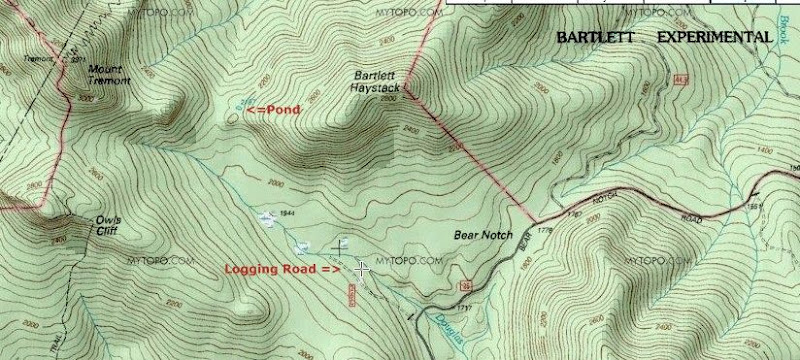
Does anyone have any insight about the little body of water situated in the col between Bartlett Haystack and Mt. Tremont (see map below)?
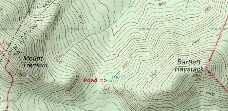
Tremont_Pond.jpg

This little speck of water recently caught my attention, and so I did a bushwhack off the Mt. Tremont Trail to check it out. By taking measurements from a topo map, I had roughly calculated that this little watery spot in the woods to be about 150 ft by 80 ft. Those dimensions seemed to be pretty much consistent with what I saw when I arrived at this body of water. Admittedly, I didn't do any actual measurements, but just merely "eye-balled it".

The best I can tell, there are no size-standards regarding what constitutes a pond or a lake. However, I think using the word "lake" for this little body of water would be a "stretch". But, on the other hand, there is a body of water in the saddle between Mts. Madison & Adams that is nearly the same size as this little guy. And guess what . . . it's called Star LAKE!:)

But, for this particular body of water, perhaps the word "pool" might be the most appropriate term. I've shared the photos posted below with David Govatski (USFS, retired). Based purely upon what he could see in the photos, he feels that this might be what is technically known as an ephemeral pool. These depressions typically only contain water during periods of snow melt, or during rainy periods, etc.

This is pure speculation on my part, but I'd think that most ephemeral pools are too small to be shown as a body of water on a topo map. Perhaps at best, they might be depicted merely as a swampy area. But given the size of this pool, maybe it retains some water throughout most of the year. If so, then it might show up on satellite imagery as a permanent body of water, and thus be depicted as a small pond on the current-day topographic maps.

I've looked at some of the historic topo maps that are available online and I didn't find this body of water. I suppose this could mean either that it didn't exist when the maps were made, or simply that no one knew it was there!

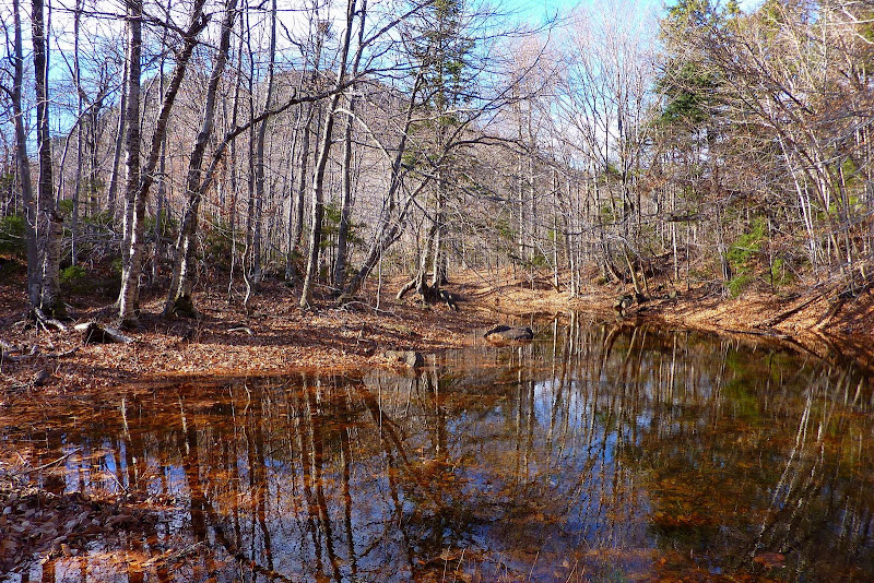
Anyway, below are two snapshots. The first photo was taken from the western end of the pond/pool. The second photo was taken from the eastern end looking toward Mt. Tremont which can be seen sort of silhouetted through the trees.
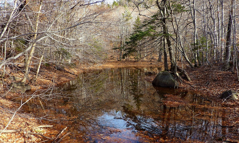
P1080003.JPG


P1070988.JPG

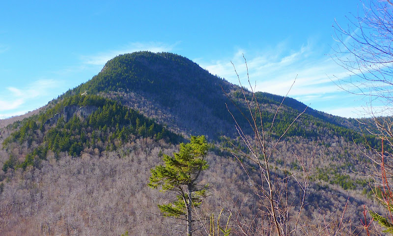
Speaking of Mt. Tremont, I extended my bushwhack to include a small ledge that's just about a tenth of a mile west of what I've nicknamed as "Tremont Pond". From this ledge, I got a somewhat unique close-up view of Mt. Tremont (see photo below).
P1070999.JPG

1HappyHiker
 
Last edited:
I recall a discussion years ago, probably here, where it came out that the official distinction between "lake" and "pond" is that a "lake" is too deep for plant growth at its deepest point--insufficient light gets through. As you note, I'm not sure that's been consistently applied in the Whites! (Although I understand Eagle Lakes used to be less swampy.)

Haven't winters in the Whites been drier in the last five years or so than in the 90s? Its possible this used to be a more substantial body. Your guesses sound reasonable...if it shows up on aerial imagery, USGS probably isn't going to bushwhack in. "Pool" sounds right to me.
 
What a great post! That's just the kind of nutty thing that I think is cool. My TOPO! program shows what I assume to be an old skidder road just beyond the upper crossing of Douglas Br. and heading into that pass from the south from Bear Notch Rd. Did you see any evidence of that?

Bartlett Haystack is on a To Do list for me and this has moved it up a few notches. I also agree that you get to call it whatever you want. Tremont Pond works just fine for me. Or you could give it a somewhat obscure Native American name with a questionable pronunciation so future generations can argue about the proper way to say it;)
Bob
 
Here's a thought:

The Unnamed Lake
- Frederick George Scott (1861-1944)

It sleeps among the thousand hills
Where no man ever trod,
And only nature's music fills
The silences of God.

Great mountains tower above its shore,
Green rushes fringe its brim,
And o're its breast for evermore
The wanton breezes skim.

Dark clouds that intercept the sun
Go there in Spring to weep,
And there, when Autumn days are done,
White mists lie down to sleep.

Sunrise and sunset crown with gold
The peaks of ageless stone,
Where winds have thundered from of old
And storms have set their throne.

No echoes of the world afar
Disturb it night or day,
The sun and shadow, moon and star
Pass and repass for aye.

'Twas in the grey of early dawn,
When first the lake we spied,
And fragments of a cloud were drawn
Half down the mountain side.

Along the shore a heron flew,
And from a speck on high,
That hovered in the deepening blue,
We heard the fish-hawk's cry.

Among the cloud-capt solitudes,
No sound the silence broke,
Save when, in whispers down the woods,
The guardian mountains spoke.

Through tangled brush and dewy brake,
Returning whence we came,
We passed in silence, and the lake
We left without a name.
 
Last edited:
Apologies for the delayed response to the replies to this thread . . . got tied up with other stuff, plus been out hiking!;)

Jon; Tim; Dug; Audrey: Thanks guys for your comments, and for taking time to post a reply!

What a great post! That's just the kind of nutty thing that I think is cool. My TOPO! program shows what I assume to be an old skidder road just beyond the upper crossing of Douglas Br. and heading into that pass from the south from Bear Notch Rd. Did you see any evidence of that?

Bob . . . first of all, it's great to hear that at least one other person likes "nutty things" such as this! To each their own, but I must admit that I do find it fun & fascinating to visit seldom-visited places in the forest!:)

Anyway, to answer your question, I'm unsure exactly what it might have been, but I did see some faint evidence of what could've been an extension of the road that I think you're talking about. Take a look at the map below. Is the road that I labeled as "Logging Road" the same road that you're referring to?
Regardless, there was some faint trace of something that came up from the south of the col and proceeded down the other side on the northside of the col.

Tremont_Pd.jpg

Here's a thought:

The Unnamed Lake
- Frederick George Scott (1861-1944)
Papa Bear . . . Thank you for posting that very fitting poem. Especially poignant and appropriate is the last verse which you bolded:

Through tangled brush and dewy brake,
Returning whence we came,
We passed in silence, and the lake
We left without a name.

I think it's indeed appropriate to leave this remote place "without a name"!
 
Here is a nicely worded statement with some examples, but no mention of pool.
http://www.maine.gov/dep/blwq/doclake/lkepond.htm
Thanks Thom for posting that reference. Yeah, I don't know what to think.:confused: As stated in the reference you posted, "there is no exact technical distinction between lakes and ponds".

And, then when it comes to ephemeral pools, the distinction is equally fuzzy. As is stated at the end of the article that I've linked below, definitions vary from State to State.

http://www.uri.edu/cels/nrs/paton/whatisavp.html

The definition issue about what constitutes a lake/pond/pool is definitely interesting. But, what I find even more intriguing is what criteria a cartographer uses to determine what to show as a body of water on a topographic map. Not being a limnologist, I have no idea if the "Tremont Pond" that I visited is an ephemeral/seasonal pool. But if it is, then it's unclear to me why it would be shown as a body of water. You'd think that depiction of bodies of water on topographic maps would be reserved only for PERMANENT lakes & ponds.

Ah well . . . who is it that said: "All that is certain is that nothing is certain."?;)
 
This is fun stuff for me, cause I majored in geography :)

I find that...it depends on where you live in the US when people are naming lakes or ponds. I used to think it had to do with size and depth of the body of water. But when you look at some of the names of the bodies of water in NH...there are many "lakes" that many would think of as ponds at best....Dream Lake, Lonesome Lake, Star Lake, just to name a few. So, I think it is a cultural thing. Lake Winne is the largest lake we have in NH, while in places like Texas, they may call that a pond. So it depends on where you live....if that made any sense.

As for the pool up near Tremont, refer to this
http://www.wildlife.state.nh.us/Wildlife/Nongame/RAARP/Vernal_pool_manual.pdf

If it doesn't have an outlet, it might be defined as a vernal pool. But the question is, does it dry up during the summertime? I see that there is a little "bump" in elevation above the pool and a flat area so it would be a perfect place for water to hang out for extended periods of time. My best guess is that it could be known as "Astatic Waters" which is a body of water that doesn't completely dry up from year to year, but will fluctuate depending on the season. See page 4, at the bottom for a great description.

I'm gonna continue to read the vernal pool paper, its interesting so far!
 
Phil . . . hey, I think you might have nailed it! Of course someone would have to do a study and do some careful recordkeeping to prove that this little pond/pool is an "astatic" body of water. But, assuming for the moment that it is, then that would answer my question as to why it shows up on a topographic map. According to the definition on page 4 of the document you linked, these particular bodies of water "do not dry up completely each year, but rather fluctuate dramatically in size from large, seasonally flooded basins to small permanent pools."

So, if there is some element of permanence to this pond/pool, then it would seem logical for a cartographer to include it on a topographic map. It just wasn't making sense to me for this body of water to be included on a topo map if it was something like a temporary/ephemeral pool.

Thanks for posting this info . . . very useful & interesting!
 
Last edited:
There is very little ground truthing of USGS topo maps, so whatever appears to be water on the air photos when flown typically end up as water bodies on topo maps. Ditto in Arctic Canada, where I have searched for ponds that were mistakenly mapped as water bodies from late-lying snowbanks on the air photos. Of course, that will be not as much of a problem in the future if air photos are ever flown again, as most of the snowbanks and small ice caps present in the 1960s are gone now.
 
That sure looks like a vernal pool to me.

Or rather, ecologically it sure looks like it functions most like a vernal pool -- no fish, periods without water, probably supports characteristic "vernal pool" species, etc.

Nature doesn't create water bodies in discrete categories. Scientists create categories so that there is a handy way to speak about things.


Edit: Clearly you should be carrying this with you in the field!

http://www.wildlife.state.nh.us/Wildlife/Nongame/RAARP/Vernal_pool_manual.pdf
 
Last edited:
I've followed that logging road

I had one of my crazy ideas of taking that logging road into the notch between Tremont and Bartlett Haystack. The logging road has # of rt hand turns that I thought would lead to the notch. I checked them all out. One of them appeared to be the one that would take me to the notch. I could see some ledges to the southeast, but shortly came upon a logged area that had incredibly thick young hardwoods that would have required an army tank to penetrate. If it hadn't been so late in the day I might have taken a crack at it. I ought to go back now that I have GPS so I wouldn't waste time on the wrong roads.

Thanks to 1HH for posting and reminding me how much I'd like to visit Bartlett Haystack some time.
 
Top