NH topo map snippet quiz

vftt.org

Help Support vftt.org:

This site may earn a commission from merchant affiliate links, including eBay, Amazon, and others.

arghman

New member
Joined
Sep 1, 2004
Messages
1,352
Reaction score
153
Location
Goffstown, NH Avatar: No Once-lers or thneeds
ok, I'm a warm-weather hiker & have too much indoor time on my hands waiting for next spring (& avoiding other things)...

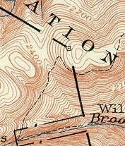
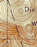
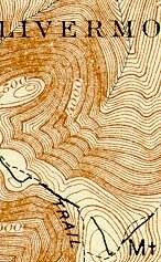
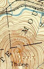
here's a quiz: Identify the current name of each of the following reasonably-well-known natural features in New Hampshire. These are small cropped images from the Historic USGS Maps of New England collection. North is up in all cases (e.g. these are all crops, no rotation) Some should be easy and some are difficult. Bonus points if you give a reason for what part of the image either gives it away or makes it more confusing than it ought to be.

1.
316763157_37e0961468_m.jpg
2.
316763168_97624f6ad7_m.jpg
3.
316763176_8d91c7e0cf_m.jpg
4.
316763198_405d08f5af_m.jpg
5.
316763204_379759eac0_m.jpg


6.
316763212_143e832793_m.jpg
7.
316763220_8510e40ba3_m.jpg
8.
316763239_87d723abf6_m.jpg
9.
316763250_50252f508d_m.jpg
10.
316763262_0aa166b2f2_m.jpg
 
1, 3, 10

1. The "other" Owls Head near Jefferson, NH (Mt. Martha).
3. Welch-Dickey...one of my favorite big-little mountains
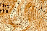
10. Bondcliff

Love lookin at (more like studying) maps... :) Fun quiz
 
Last edited:
Number 5 is Mt. Washington? I think that is Sargents purchase.

WSC
 
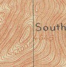
#9 South Carter

The elevation isn't right, but it's the only peak that comes close. The bump north of it is Mt. Leyte...I think.

The elevation on #5 and the ravine to the NW make it resemble Mt. Adams.
 
Last edited:
I think I have 9 of the 10....I didnt look at any of the other posters.

1. Owls Head by Mt Martha
2. I HAVE NO FRICKIN CLUE
3. Welch and Dickey
4. Mt Guyot
5. Mt Pleasant (Eisenhower)
6. North Sugarloaf near Rt 302 (Zealand Rd)
7. Lake Gloriette in Dixville Notch
8. The Horn
9. South Carter?
10. Bondcliff

Number two is next to impossible. One hint...just one. :eek:

grouseking
 
Papa Bear said:
#9 South Carter. the "South" and the Meridian line running through it.
Ahah! a trick question. My guess for #9 is changing:

#9 Middle Carter

I just remembered the old 15' map has the names of South and Middle Carter reversed! There was an old thread (abought Mt. Hight) where this was mentioned (by me!) which I can't find at the moment.

I also just noticed that the quiz asked for the "current" name so my guess for #5 (Pleasant Dome) has to be Eisenhower.
 
I looked and looked some more and finally found #2

#2 Arethusa Falls on Bemis Brook. The "Wil" is for "Willey House" off to the east on Rte 302.

The mountains above the Falls are unnamed. I spotted the little jig-jag in the boundary line around the brook.
 
some quick thinking here! Grouseking and Papa Bear -- if there were a viable career in map detective work I think you both would do well ;)

answers follow (with links to the source map from the UNH site, warning as these are approx 2MB jpg):

1.
316763157_37e0961468_m.jpg
2.
316763168_97624f6ad7_m.jpg

1 Cherry Mtn (Owls Head)
audrey said:
(The "Ow" and altitude gave it away)
2 Arethusa Falls
Papa Bear said:
I spotted the little jig-jag in the boundary line around the brook.
very distinctive, the only part of Crawford Notch State Park which is outside the town of Harts Location. Red herring: the "ATION" in the image is part of "CRAWFORD NOTCH STATE RESERVATION" and not "NATIONAL FOREST" (the latter appears frequently on these maps)
3.
316763176_8d91c7e0cf_m.jpg
4.
316763198_405d08f5af_m.jpg

3 Welch & Dickey
4 Mt Guyot Red herring: the "Livermo" -- this little isolated bit of Livermore (in the Little River watershed) was left behind when the state legislature transfered all of the land in the Pemigewasset R watershed to the town of Lincoln. They fixed it a few years later, but it showed up on the maps in the interim.
5.
316763204_379759eac0_m.jpg
6.
316763212_143e832793_m.jpg

5 Mt Eisenhower Formerly "Pleasant Dome" on the topo maps. Red herring: This early topo map forgot the township of Chandlers Purchase, in which the mountain lies (the summit is about 500' W of the boundary with Sargents Purchase).
6 N Sugarloaf The "Z" is probably helpful; there aren't too many of those around. The "Three" refers to "Three Sugarloaves".
7.
316763220_8510e40ba3_m.jpg
8.
316763239_87d723abf6_m.jpg

7 Lake Gloriette (alternatively: Table Rock)
8 The Horn Not too many "The"s with altitudes in the 3900-4000ft range.
9.
316763250_50252f508d_m.jpg
10. [ wtf? you can only include 9 images if you're not the original poster?! ]
9 Middle Carter
Papa Bear said:
I just remembered the old 15' map has the names of South and Middle Carter reversed!
I noticed this myself yesterday with delight & just had to include it

10 Bondcliff altitude clues, lettering is part of "The Cliffs" and the trail is rather distinctive.
 
Top