Pemi loop

vftt.org

Help Support vftt.org:

This site may earn a commission from merchant affiliate links, including eBay, Amazon, and others.
Guess everyone beat me on the mileage. AMC Guide distances total 31.5 miles (not counting Galehead or West Bond) and time is 22 hrs. I assume it doesn't take that long? For those of you who have done the full loop what were your times? (Approximate is fine-don't need GPS data). Give me an idea of how intense this is. This will be the longest hike I've attempted by a considerable amount.
 
Back in the 90s, before it was widely referred to as the Pemi Loop, I used to call it the Pemi Lollipop... for obvious reasons. Now I call it the Pemi Loop, though, because it rolls off the tongue easier. :D

Times vary widely depending on time of year/trail conditions, your fitness level, how much you carry, whether you plan to run any of it, etc.
 
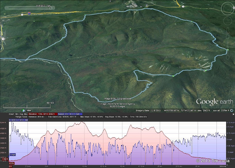
15:38 in September, of which I was not moving for about 3 hours. For my clockwise loop, the crux was the climb up South Twin, after which there is not much elevation remaining and what remains is not very steep (refer to the picture above with the elevation profile.)

Tim
 
I assume it doesn't take that long? For those of you who have done the full loop what were your times?
Do a search on trip reports here - times range between the rabbits (7 hours) to the tortoises (20+) and everything in between. One person has even done a double loop. I've done it once in 12:30.
 
For my clockwise loop, the crux was the climb up South Twin, after which
Tim

The only section of the loop I have never done is the Garfield Ridge section from the Skookumchuk Trail junction to the Galehead Hut. It has been a very long time since I did the section from there up to South Twin. This looks like it could be a spot that proves to be a "back breaker". From what I've read that section is very rugged.

Are either of the trails leaving down into the valley from Galehead Hut worth it as a "bail out" if I should decide I can't handle the whole loop or is it just as easy to stay on the ridge and tough it out? I've read that the upper parts of those trails are hard to navigate and thinly traveled. Just curious if that was a viable option or not if fatigue or an injury becomes a factor.

Lastly, SEVEN hours !!! I'm pretty sure I will be no where near that time. Yikes.
 
The marathon (26.2), Ironman (140.6), Ultramarathon (100) stickers are generally pretty unadorned and obvious. If you want to replicate that effect, a simple "Pemi Loop" in an oval would suffice.

Pemi Loop.png

-Dr. Wu
 
Are either of the trails leaving down into the valley from Galehead Hut worth it as a "bail out" if I should decide I can't handle the whole loop or is it just as easy to stay on the ridge and tough it out? I've read that the upper parts of those trails are hard to navigate and thinly traveled. Just curious if that was a viable option or not if fatigue or an injury becomes a factor.
Yes, dropping down from the hut to the Franconia Brook trail is a common bailout route. It's pretty well traveled so I don't think route finding would be a problem in summer. The bailout routes to the north are probably easier but you'll need a car drop.

Lastly, SEVEN hours !!! I'm pretty sure I will be no where near that time. Yikes.
Actually, the current record is 6:27 IIRC. There are some fast folks out there.
 
The marathon (26.2), Ironman (140.6), Ultramarathon (100) stickers are generally pretty unadorned and obvious. If you want to replicate that effect, a simple "Pemi Loop" in an oval would suffice.

View attachment 4871

-Dr. Wu

Dr Wu, "are you really just a shadow of the man that I once knew?"
I thought you died but I guess Katy lied. I hope you have not spent your last piaster.

I agree with Dave, 50K is a nice round number and its about time we went metric.

Pemi loop times? Any time preceded by the word "finishing" is a good time. Good on ya mates.
 
The only section of the loop I have never done is the Garfield Ridge section from the Skookumchuk Trail junction to the Galehead Hut. It has been a very long time since I did the section from there up to South Twin. This looks like it could be a spot that proves to be a "back breaker". From what I've read that section is very rugged.
PUD PUD PUD PUD PUD. The elevation figures in the WMG are taken from map contours; there's a lot sub-contour on that section, so there's far more climbing than one might think.

You might want to take a look at Mohamed's Death March FAQ to put things into context.
 
The only section of the loop I have never done is the Garfield Ridge section from the Skookumchuk Trail junction to the Galehead Hut. It has been a very long time since I did the section from there up to South Twin. This looks like it could be a spot that proves to be a "back breaker". From what I've read that section is very rugged.

Are either of the trails leaving down into the valley from Galehead Hut worth it as a "bail out" if I should decide I can't handle the whole loop or is it just as easy to stay on the ridge and tough it out? I've read that the upper parts of those trails are hard to navigate and thinly traveled. Just curious if that was a viable option or not if fatigue or an injury becomes a factor.

Lastly, SEVEN hours !!! I'm pretty sure I will be no where near that time. Yikes.

The Twin Brook trail that leaves from the hut along with the Frost Trail which goes up Galehead is a nice option for bailing out. (I used it on both of my attempts back in 2006)

Garfield Ridge, as mentioned has a lot of PUD. I've done it completely twice and the piece between Garfield and the Twinway another day. It's my least favorite trail. (I've not done a lot in the Great Gulf, or non Standard approaches to the Northern Presidentials.)
 
Last edited:
The Twin Brook trail that leaves from the hut along with the Frost Trail which goes up Galehead is a nice option for bailing out. (I used it on both of my attempts back in 2006)

Yes, dropping down from the hut to the Franconia Brook trail is a common bailout route. It's pretty well traveled so I don't think route finding would be a problem in summer. The bailout routes to the north are probably easier but you'll need a car drop.

So either trail is well traveled? Did you mean Twin Brook Dave? Now that I have a map in front of me I see that the Franconia Brook Trail actually leaves the ridge approx 2 miles before the Galehead Hut and the Twin Brook Trail actually leaves from the hut. Are there any pluses or minuses to one over the other (other than the obvious added 2 mile slog if you stick it out to the hut before throwing in the towel? Twin Brook looks quite a bit steeper leaving ridge but Franconia Brook sounds rougher, muddier and harder to follow according to AMC Guide).
 
Twin Brook is what I meant, it's the quickest bailout route, but either should be fine. The trail that is a mess is the Lincoln Brook trail from 13 Falls to the Owlshead slide. But the other trails are fine.
 
Twin Brook is what I meant, it's the quickest bailout route, but either should be fine. The trail that is a mess is the Lincoln Brook trail from 13 Falls to the Owlshead slide. But the other trails are fine.

OK. Thanks for the clarification. It looks like Franconia Brook "bail out" saves 5hrs 35 min and 6.5 miles off the loop (AMC Guide distances and times) and Twin Brook "bail out" only 3 hrs 10 min and 3.6 miles off the loop. So I guess if I'm entertaining throwing in the towel by the time I reach Franconia Brook it's probably worth it to head down over there rather than push it.

I may do that "inner Pemi Loop" as a pre-hike to familiarize myself with the area, the navigational issues and build up endurance for the actual Loop. I hate to do a hike of that magnitude with gaps in my knowledge of the area.
 
It looks like Franconia Brook "bail out" saves 5hrs 35 min and 6.5 miles off the loop (AMC Guide distances and times) and Twin Brook "bail out" only 3 hrs 10 min and 3.6 miles off the loop. So I guess if I'm entertaining throwing in the towel by the time I reach Franconia Brook it's probably worth it to head down over there rather than push it.
The bail-outs also get you off the ridge and once you pass Camp 13 Falls tentsite the trail is a nice level railbed.

Doug
 
The trail that is a mess is the Lincoln Brook trail from 13 Falls to the Owlshead slide. But the other trails are fine.

The Lincoln Brook trail from 13 Falls to the Owlshead slide has seen a lot of maintenance over the last few years, especially the section south of 13 Falls. The trail does get tricky at the height of land. The route finding ability can be required especially in late Fall and winter when the tread is hidden. The trail is not as difficult to follow as it was a few years ago.

I like PEMI or PEMI LOOP in the OVAL, maybe a dark green font color rather than the traditonal black.
 
Guess everyone beat me on the mileage. AMC Guide distances total 31.5 miles (not counting Galehead or West Bond) and time is 22 hrs. I assume it doesn't take that long? For those of you who have done the full loop what were your times? (Approximate is fine-don't need GPS data). Give me an idea of how intense this is. This will be the longest hike I've attempted by a considerable amount.
My 4 attempts: 16 hour clockwise + Galehead, a 14 hour clockwise, a bailout down twin brook for thunderstorms counterclockwise, and a bailout down twin brook for cramping clockwise. And yes, clockwise the ascent up South Twin is absolutely the crux.


ge.jpg


Maybe you want the elevation profile? (this one has the speed as well, but could be removed...)

Tim
Tim, Do you have a GPX file of that?
 
Last edited:
I'd go with just plain "PEMI" -- the only people who are going to get it anyway are those of us who get it.
The "Pemi" is a region, the "Pemi Loop" is a specific route (made specific by usage).

Counter example: Becca and I skied a "Pemi lollipop" (Lincoln Woods > Thoreau Falls Tr > Shoal Pond Tr > Lincoln Woods) which used none of the trails of the Pemi Loop.

Doug
 
The "Pemi" is a region, the "Pemi Loop" is a specific route (made specific by usage).

I get that, but I'd kinda figure anybody with a 'yay me' oval bumper sticker about it isn't referring to their trip to Shoal Pond or Cedar Brook or whatever. Sort of like 26.2 is just a number, but when I see it on somebody's tailgate I know it's probably not the weight of their beagle in pounds, their average in freshman chemistry, their lifetime tally of romantic partners, etc.

Then again, if you or anybody else want to rock a PEMI sticker because you skied there or fished there or whatever else you did, I don't mind at all ...
 
Last edited:
Top