Thorn Mountain in Jackson

vftt.org

Help Support vftt.org:

This site may earn a commission from merchant affiliate links, including eBay, Amazon, and others.

JustJoe

Active member
Joined
Mar 10, 2010
Messages
690
Reaction score
51
Location
Ipswich, Ma.
I've been spotting this smallish mountain with a great looking ledge at the top from Rt. 16 a couple miles before the junction with 302. I finally decided to try and figure out what it was. I'm pretty sure it's the back side of the old Thorn Mtn. ski area in Jackson. Is anyone familiar with this. Is it private land, i.e. no trespassing or is it legal to climb. It would be nice to check the old ski area and the, views from the top, (no pun intended). My Garmin maps also show a trail on the west side off Thorn Hill Rd.
 
Joe, I see what you're seeing, i.e. the ledge + the trail on the west side of Thorn Mtn that begins off Thorn Hill Rd. But, that's about as far as I can take it. Besides the potential issue with private land, probably the other issue would be with parking.

In the "for what it's worth" department, for unconventional treks such as this, I've had some limited success with merely knocking on a door and asking a landowner for permission to park and walk the land. Doesn't always work, but it's always worth a shot!
 
Dundee Road on the east and southeast has potential. IIRC it may have some potential parking spots. You would need to be careful navigating back, though. It does have it's share of back yards.
 
Thanks. At any rate, it will be worth closer investigating next time I'm in the area without a plan.
 
I have hiked up a trail from the W that used to be in the AMC guide, perhaps the one shown on the USGS map. The sign at the trailhead wasn't obvious but I knocked on a door and the resident told me where it was. Of course this was in a previous century and conditions may have changed.
 
That's the old Tyrol Ski Area. The folks on the north side, where the lodge used to be, have spent several small fortunes on "No Trespassing" signs. That's OK, at least you know where you stand. I don't know about posting down by that trail but unposted land in NH is open. It is always nice to find the owner and ask permission just to let them know that you're there. If the owner comes along and asks you to leave then you must but our state laws protect the open land use. I've always been successful by being cool, polite, staying out of dooryards and LNTing.
Bob
 
This trail appears on my old maps, through 1979. It used to form a loop from Jackson, with the first parts being by road. It passed by the George Washington Boulder.

As REK points out, part of the trail got converted to a ski trail as part of the now-closed Tyrol Ski Area. The trailhead is posted as private. There's now no access that way.

I found the other trail segment by bushwhacking my way to it. It's in great shape. The view from the summit is excellent. The trick is knowing where to enter.

Directions to the other trailhead in my 1979 AMC Guide were not very helpful. "(From Jackson) Ascend the Thorn Hill Rd. about 1 mi. to a driveway opposite open field on R. (Look for Thorn Mountain Trail sign). Turn L (E) into driveway (through large evergreens) from which the trail leaves on the R." There are lots of driveways there now, and no nearby place to park. There's no trail marker on the road, but there is a small sign up the driveway, if you can figure out which driveway. Fortunately, that's not needed. There's a spur trail that's not on my old maps that's a better point of entry.

From Jackson drive up Switchback Way to Thorn Mountain Rd., then on up to Alpine Dr. ("Upper" Alpine on Google Maps). Stop to take a look at the George Washington Boulder on the way up. At the end is a clearing that looks to be the location for a future home. Walk out into that clearing and look carefully to your left. You'll see blazes as the clearing's edge aligns with the spur trail. Follow the spur to the main trail. You'll be at the summit in about 20 minutes.
 
I don't believe Thorn Mtn. has any major ledges. The ledges you see are on Thorn Hill, which is on the west side of Thorn Hill Rd., and are visible from 16. On the east side of Thorn Hill Rd. is Thorn Mtn. Dundee Rd. borders the east side of the mountain. I have whacked up the west side from Thorn Hill Rd (on a day where I was really just tooling around with the dog off Thorn Hill Rd.). There is a Mt. Washington Observatory camera on the summit. The Tyrol ski area is on the north side of the mountain and is private property. Lost ski areas of NH has some info.
 
There's a ledge with an excellent view from Thorn Mountain. From the summit, where there's a weather station, and I now presume a Mt. Washington Observatory camera, head west through a small group of trees to reach the ledge.

There's no ledge on Thorn Hill. I live on Thorn Hill. There's an excellent view if you want to drive up to the top.

Here's a photo from the ledge on Thorn Mountain. The nearby hill with the houses on it is Thorn Hill.

IMG_0583.jpg
 
There's no ledge on Thorn Hill. I live on Thorn Hill. There's an excellent view if you want to drive up to the top.

Then I must be confused. The topo map shows the big ledge (cliff really) on the north side of 16 to be the southern portion of Thorn Hill. There are homes on the north and west sides of Thorn Hill, and Story Land is on the lower west side. To the east is Thorn Hill Road. Are you saying the cliffs on the southern part of Thorn Hill are not really part of Thorn Hill? Curious, as I have always viewed them as being on the hill and the map seems to confirm that.
 
There's a ledge with an excellent view from Thorn Mountain. From the summit, where there's a weather station, and I now presume a Mt. Washington Observatory camera, head west through a small group of trees to reach the ledge.

There's no ledge on Thorn Hill. I live on Thorn Hill. There's an excellent view if you want to drive up to the top.

Here's a photo from the ledge on Thorn Mountain. The nearby hill with the houses on it is Thorn Hill.

View attachment 4968

Thanks. I knew from looking at it on Google Earth, there is a lot of ledge on the summit. Which can be seen from Rt. 16. Maybe someday I'll try and get permission from a local to hike up.
 
Maybe someday I'll try and get permission from a local to hike up.

The question is who to ask. I assume (perhaps incorrectly) that the ski area is largely owned by the person who purchased the home and buildings at the base (Tyrolean Drive?), which I note is higher in elevation than the bottom of the lifts (according to Lost Ski Areas of NH). Any other entry point probably involves another landowner as well. The topo map shows an old trail going up from Thorn Hill Road, which sounds like the one Doug references from the old guidebook. Going in south of that the woods are all open (in the fall/winter) -- you can see forever if you look into the woods from Thorn Hill Rd.
 
this one is on my short list so i drove through on thorn hill road a few weeks ago to scout it out. where the usgs shows a road and then trail ascending from the northeast i'm pretty sure access was posted or involved walking through someones yard, but at the height of land there were no homes nearby, it was not posted and there is a good shoulder to park on. woods look wide open. that's the ascent route i currently plan on using when i take a shot at it. the impression i get is that there is some sort of ledge up there with potential views.

bryan
 
I'm not saying that the cliffs on the southern part of Thorn Hill are not on Thorn Hill, although I would not call them a ledge that looks like it would have a particularly good view. I'm talking about the ledge on Thorn Mountain that JustJoe wants to get to, and which has a good view.

Unless one is trying to access that ledge via the old Tyrol Ski Area, which is clearly marked as private, I don't think permission is needed. I've been there several times. I usually go by the route I recommended above, off Alpine Drive. If you're willing to briefly walk up a couple of driveways in error, you'll find the trailhead off Thorn Hill Rd. There's a sign marking the trail, and shortly after the sign there's a bridge crossing a small brook. This does not look like the behavior of a property owner who is opposed to hikers. They probably just don't want people parking in their driveway or clogging up Thorn Hill Rd next to their driveway.
 
Got it Doug, thx. As noted above, I once whacked up from Thorn Hill Rd. in the fall. Very easy and less than a mile IIRC. There's a drainage that is obvious on the sat map and until just below the summit it is wide open (but even the summit area is not particularly dense). There's a trail that wraps around the southern part of the summit.
 
My suggestion would be to call the folks at Tin Mountain Conservation Center, which has a field station in Jackson off Tin Mine Road where they run some of their summer camp programs. The Education Director probably knows about access to Thorn Mountain and I know that explorations of the old Dundee Road have been part of their programming in years past. If someone there doesn't know for sure they undoubtedly know someone who does. I would give them a call .... 603 - 447 - 6991
 
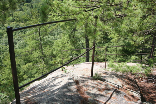
There are indeed two separate peaks, Thorn Mountain with the ski area, and Thorn Hill which has a ledge at its northern end (not at its summit). For the Thorn HIll ledge, there's an unposted trail leaving from the dumpster for the vacation homes just below the ledge, off Christmas Mountain Road (access from Mittenwaldstrasse, at Kringle's Country Store on rte 16) . You can see the ledge from Crhistmas Mtn Road; the dumpster is to the right of the gazebo. Just before reaching the ledge, the trail passes inches from the driveway and garage for a large building (private mansion? with driveway leaving Thorn HIll Rd near Farnum Ln ) but as far as I can tell does not infringe that property. There is old ironwork on the ledge, suggesting that this was once a popular spot.

m001.jpg


(not shown: good views to the southwest)


edit: I checked my map after reading NHClimber's comments more carefully. The southern end of Thorn Hill also has a cliff (or two - satellite shows a band of trees which would indicate a balcony), that looks bigger than the ledge I've described above. I don't know if there's any trail to the southern cliff, but there's a road within Story Land that ends just below it.
 
Last edited:
There's no ledge on Thorn Hill. I live on Thorn Hill. There's an excellent view if you want to drive up to the top.
The true summit of Thorn Hill is wooded ledge outcrops with no views. I bushwhacked up from Thorn Hill Rd at a different point than the Thorn Mtn Trail
 
Top