Twins/galehead loop

vftt.org

Help Support vftt.org:

This site may earn a commission from merchant affiliate links, including eBay, Amazon, and others.

SherpaTom

Member
Joined
Oct 6, 2003
Messages
178
Reaction score
4
Location
Bellingham, Ma
A couple of years ago, we were going to attempt this hike and Bikehikefish gave us info on doing this loop in the winter.

http://www.vftt.org/forums/showthre...Galehead&highlight=twins+galehead+loop+winter

I saw the recent post to follow the Little River to the N. Twin trailhead from the end of Little River Road and not following the snowmobile tracks.

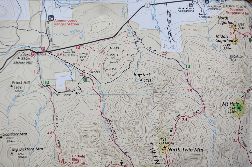
Few questions, when you hit Haystack Rd leading to the trail head, please clarify which direction (left or right) to get to trailhead? Also, when descending Gale River and after taking left on the Gale River Rd, is the campsite marking #3 still the way to beaver Brook ski parking lot?

Thanks
 
Why not just go in on Haystack Road ? It does look like a left, if anything, after the river on Haystack Rd though.
I guess you're calling Haystack Rd the snowmobile tracks and that's why you might not want to be there.

001.JPG
 
Last edited:
I asked a similar question a few weeks ago for the Twins (which I did Friday):

-Parking at the end of Little River Road and taking the bushwhack to North Twin Trailhead is only about 1.0 mile versus a 2.5 mile walk on Haystack Road so if you're spotting cars at both ends you save a lot of long boring walk on Haystack Road. Haystack Road did appear to have somewhat of a track on it though (at least for the short distance I could see) so it is getting used (looked more by cross country skiers than hikers though).

-As everyone previously mentioned, the bushwhack after the bridge is extremely easy to find and follow. It is on the left immediately after crossing bridge out of the parking area. It's as obvious as any trail out there and was a nice, firm, frozen granular track suitable for however you want to take it (bareboot, spikes, snowshoes, skis). At the other end when you come out on Haystack Road you'll be just before the bridge and summer parking area (which is just to your left in view). Was a very simple bushwhack.

-When I asked similar question on this route I believe it was the #3 site that returned to Beaver Brook. I did an out and back so I can't confirm that though.

This route is in fantastic shape right now (at least too South Twin where I turned around). There was a group of 6 wearing spikes that headed down toward Galehead and was planning on going out Gale River Road when I summited so at a bare minimum there should be tracks to follow. I suspect a lot of people will hit this area over the weekend. Good time to get out there and do it.
 
BTW, if you look at the USGS Topos for this area, you'll see a marked trail from the end of Little River Rd to just before the current summer trailhead.

I've seen some folks refer to this as a "herd path" or "bushwhack", but it isn't really. At some point, it was an official trail, and it is still heavily used as a XC ski trail in the winter, so is nearly as well-defined as any "official" trail in the Whites. It has every appearance of being maintained, but not blazed. In the summer, it is a popular route to a particular swimming hole in the Little River downstream from the summer trailhead. So this trails is incredibly easy to follow.

Usually when folks talk about the "herd path" going up North Twin, they're really referring to the path on the east side of the Little River between the 1st and 2nd river crossings.

NT_Trail.jpg
 
Top