Updated Trail Bandit Ossipee Mountains Map & Ossipee 10 List Update

vftt.org

Help Support vftt.org:

This site may earn a commission from merchant affiliate links, including eBay, Amazon, and others.

rocket21

Well-known member
Joined
Jan 29, 2007
Messages
2,268
Reaction score
318
Two Ossipee Mountains (NH) updates:

A new version of the Trail Bandit Ossipee Mountains Map (as of 9/21/08) has been posted: The Trail Bandit Ossipee Mountains Map

Some more trails and logging roads have been added since the last update in July.


As such, Black Snoot has been replaced on the Ossipee 10 List with Larcom Mountain. Black Snoot, a scenic subpeak of Mt. Shaw, was on the list as a placeholder until a suitable replacement cold be found. Larcom Mountain features multiple viewpoints from its ledgy summit.

The Ossipee 10 Hiking List
 
Unfortunately the new map now has Faraway Mtn shown at a different location than the USGS and the original estate placed it. Since this error was made deliberately, the user can't be sure what other deliberate errors might be on this map hence can't fully trust the map. (full discussion of this issue at rocksontop.com)

It would be nice if somebody could post the more complete and more accurate Ossipee Range map made by the guy who made the Belknap Range map (I am not posting his name as in the past he hasn't placed his name on his maps so I assume he prefers to remain anonymous.)
 
RoySwkr said:
Unfortunately the new map now has Faraway Mtn shown at a different location than the USGS and the original estate placed it. Since this error was made deliberately, the user can't be sure what other deliberate errors might be on this map hence can't fully trust the map. (full discussion of this issue at rocksontop.com)

I don't know if I agree with the statement that this map is filled with deliberate errors. Using the argument regarding Faraway Mountain, wouldn't one be able to consider the AMC maps showing Owl's Head as the 4,0XX' peak to be deliberately in error, when Owl's Head is actually the southern knob of that mass?

I think there were some more recent developments in the Faraway Mountain location issue (beyond the RoT thread), but I don't recall the specifics.

I have many Ossipee Mountains maps (and I suspect based upon the peakbagging you've done over the years, you have even more maps of the range than I do), including the Castle map, the map from which it is based (which is the one you refer to in your post), and various versions of the Trail Bandit map, along with the older AMC maps that show portions of the range. I can say without any hesitation that, based upon the hiking I've done in the range over the last two years, the Trail Bandit map is the most complete and accurate of the bunch.
 
Larcom has parking on private land. Perhaps there is a sign now.
 
RoySwkr said:
Unfortunately the new map now has Faraway Mtn shown at a different location than the USGS and the original estate placed it. Since this error was made deliberately, the user can't be sure what other deliberate errors might be on this map hence can't fully trust the map. (full discussion of this issue at rocksontop.com)

Here we go again. RoySwkr has forgotten more New England summits than most of us (myself definitely included) will ever know, so I don't lightly take issue with him. Only the Pope is infallible, however, and on the question of "which is the real summit of Faraway," I respectfully submit that Roy is all wet.

Maps going back 80 years or so label as "Faraway" a lesser bump on the south end of that range, apparently because a spur carriage road, now faded or lost altogether, once went there from what what is now the LRCT's High Ridge Trail. That carried over to some later topo maps.

Those who have considered the question thoughtfully in recent decades, however, seem generally to have concluded that the logical "Faraway" is the high point - x2,782 on all recent topos I've seen. See, for instance, AMC Map 3 - Crawford Notch-Sandwich Range, from the AMC White Mtn. Guide, 27th Ed. See also the identification in the Scudder View Guide maps for Red Hill, and references from some Lake Regions Conservation Trust materials (including a newletter I have stashed away somewhere).

I don't expect to persuade Roy, but find it unfortunate that he would disparage Trail Bandit's terrific map just because Trail Bandit, too, dares to disagree. Thank you, Trail Bandit!
 
Grayjay said:
Larcom has parking on private land. Perhaps there is a sign now.

I noticed (and used) a small lot (3-4 cars) immediately across the street from the unmarked trailhead. The only sign I saw in the vicinity was a No Hunting sign, at the trailhead.
 
Amicus said:
Maps going back 80 years or so label as "Faraway" a lesser bump on the south end of that range, apparently because a spur carriage road, now faded or lost altogether, once went there from what what is now the LRCT's High Ridge Trail. That carried over to some later topo maps.
Yes, that's why I think the TB map is wrong. The guy who named it is more likely to know where it is than somebody who was there last year.
Those who have considered the question thoughtfully in recent decades, however, seem generally to have concluded that the logical "Faraway" is the high point - x2,782 on all recent topos I've seen.
These include a guy who thinks the professional surveyors of the US Coast & Geodetic Survey accidentally put the Ossipee BM on the wrong peak, and a guy who thinks Thoreau climbed Mt Shaw because his journal said he traversed the foothills of the Ossipee Range. I would say "fancifully" is a better word than "thoughtfully" :)
I don't expect to persuade Roy, but find it unfortunate that he would disparage Trail Bandit's terrific map just because Trail Bandit, too, dares to disagree.
Since I have publicly questioned maps made by the AMC and the USGS, that puts TB in good company :)

I warned TB over on ROTT that if he put this error on his map it might cause people not to trust it, and I would be remiss in not passing this warning on to others just as I have with Owls Head, Lethe, and Davis.
 
RoySwkr said:
Unfortunately the new map now has Faraway Mtn shown at a different location than the USGS and the original estate placed it. Since this error was made deliberately, the user can't be sure what other deliberate errors might be on this map hence can't fully trust the map. QUOTE]

There seems to be some different opinions about which hill in the Ossipee Mtns. should be called Mt. Faraway. The location of the printed designation on the map was moved to the highest summit of the group of hills after taking into consideration of the opinion of a number of people. The vote came out in favor of the highest hill instead of the two lower bumps beside it. The USGS doesn't usually name a ridge on the side of the peak and not name the peak itself. I have noted that RoySwkr has been very vocal with his vote but the change was made due to the number of responses and not on the volume of any particular one.
I hope that others will post their view about this so there can be a larger voting public. Also, if anyone has some real information as to where and when the mountain was originally named, I would love to see it.
I hope that hikers find the map useful and you can rest assured that an effort is being made to make it as accurate as possible.
 
Trail Bandit said:
There seems to be some different opinions about which hill in the Ossipee Mtns. should be called Mt. Faraway. The location of the printed designation on the map was moved to the highest summit of the group of hills after taking into consideration of the opinion of a number of people. The vote came out in favor of the highest hill instead of the two lower bumps beside it. The USGS doesn't usually name a ridge on the side of the peak and not name the peak itself. I have noted that RoySwkr has been very vocal with his vote but the change was made due to the number of responses and not on the volume of any particular one.
I hope that others will post their view about this so there can be a larger voting public. Also, if anyone has some real information as to where and when the mountain was originally named, I would love to see it.
I hope that hikers find the map useful and you can rest assured that an effort is being made to make it as accurate as possible.

Welcome to VFTT, Trail Bandit! Thanks for all you do.
 
rocket21 said:
Welcome to VFTT, Trail Bandit! Thanks for all you do.
Welcome to VFTT, Trail Bandit! Thanks for maintaining the trails. No thanks for deliberately moving things around on maps. You don't seem to understand how tough it is to put the genie back in the bottle. Periodically someone finds the old snowmobile map that shows the Mt Tom Trail and insists there was once a snowmobile trail up Mt Tom.

Trail Bandit said:
There seems to be some different opinions about which hill in the Ossipee Mtns. should be called Mt. Faraway. The location of the printed designation on the map was moved to the highest summit of the group of hills after taking into consideration of the opinion of a number of people. The vote came out in favor of the highest hill instead of the two lower bumps beside it. The USGS doesn't usually name a ridge on the side of the peak and not name the peak itself.
This comment shows your misunderstanding of the mapping process. The USGS doesn't name anything, rather they attempt to use the correct local names. And it is not unusual for the name to be applied to an outcrop seen from below rather than the highest point. Think "peak above The Nubble" which people were incorrectly calling "The Nubble" for awhile until Gene Daniell stamped that out.

The correct way to find a name is to ask the USGS and the estate for old records, not poll modern-day hikers. More later...
 
RoySwkr said:
Periodically someone finds the old snowmobile map that shows the Mt Tom Trail and insists there was once a snowmobile trail up Mt Tom.

There still is a snowmobile trail up Mt. Tom. It ends at about 3200'.

I found the trail before I found the map.
 
RoySwkr said:
Since I have publicly questioned maps made by . . . the USGS . . .
RoySwkr said:
The correct way to find a name is to ask the USGS ...

Trying to square these statements, I conclude that the correct way is to ask the USGS, but only when they agree with RoySwkr, which could be shortened to, ask RoySwkr. :)

I also wouldn't place too much weight on a poll. There is, however, a place for contemporary usage in determining which feature deserves what label, as that is not a purely objective question, such as "which rock is the summit"? As far as I know, neither Roy nor anyone else has determined who named "Faraway" or why - there is only speculation. Logic, the AMC, the LRCT (in their writings, at least) and Scudder's View Guide, in addition to several Ossipee fanatics I know, consider the high-point, with its trail, to deserve the name. I respect, however, RoySwkr's right to dissent.
 
<mod hat>
I'm very encouraged that this conversation has been civil and informative. I'd like to stay that way so I'm just reminding people that it's perfectly OK to disagree but to keep your focus on ideas, not people.

Everyone happy? Great.
</mod hat>
 
rocket21 said:
I noticed (and used) a small lot (3-4 cars) immediately across the street from the unmarked trailhead. The only sign I saw in the vicinity was a No Hunting sign, at the trailhead.

Was that in the middle of a field, and you climbed diagonally up the field to the left to the woods?
 
Grayjay said:
Was that in the middle of a field, and you climbed diagonally up the field to the left to the woods?

Nope, it was across the street at the south end of the field (furthest from Route 25).

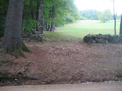
Here's the trailhead I was referring to, I was standing on the road, in front of the parking area when I took this:

littlelarcommtntrailhead-2008-0913a.jpg


I walked up the edge of the field, which wraps around slightly to meet the old logging road that leaves the field. The apple orchard is to the right.
 
rocket21 said:
Steve Smith wrote a great article in yesterday's Mountain Ear . . .

He does have some interesting things to say about hiking in the Ossipees. In addition to his mention of Jeremy's website, he acknowledges the efforts of Trail Bandit, our newest member, in rescuing some fine trails such as the Gorilla. I wouldn't recommend the route of Smith's own hike, however, which left him with a road walk of quite a few miles, after a long traverse. (A car-spot would change that.)
 
Top