Lost hiker in the Pemi

vftt.org

Help Support vftt.org:

This site may earn a commission from merchant affiliate links, including eBay, Amazon, and others.
...A friend and I compared the GPS tracks from his iphone 4s and my Garmin 60CSx: the iphone track had significant excursions from our (known) route, the 60CSx did not. (The walk was under trees, but terrain was not a problem.) Also a phone GPS drains a battery that may be needed for communication...
Just like different models of PLB, different models of phones can vary in GPS performance. Case in point:

I have a Garmin Rino 530HCx. It's the same vintage as the Garmin GPSMAP 60CSx (circa 2007). I performed extensive testing in a local forest (~30-40' canopy of mature maples), comparing four GPS apps on my late-model phone. My Garmin served as the "gold standard".

Here's what the phone did. This is eight laps around a ~2 kilometer circuit. Two laps for each of the four apps.
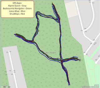


The Garmin recorded all 8 laps. Here's what the "gold standard" did:
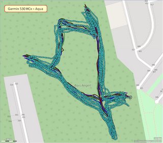


Subsequent field tests in the Adirondacks demonstrated the phone's track deviated from the "true path" about as often as the 530 HCx. However, the deviations were well within the range of GPS accuracy. I've found it to be more than adequate for general navigation and trip statistics. My friend used a Garmin 76CS for years and recently switched to using Gaia with his iPhone 5s. He reports the same level of satisfactory performance as with the old 76cs.

As for loss of GPS fix, yes, it can happen, but re-acquisition is fast. In practice, it hasn't proven to be a problem. Honestly, I've only noticed it once and that was during my last hiking trip (the first time in dozens of trips). It appeared as a straight-line segment in my track, running for several meters. For general trail-walking in the mountains, it works fine.


...the most cost-effective solution to "I don't know where I am" problem is a phone app that can download maps for off-line use...
+1
Phones are so ubiquitous that it's disheartening to hear when someone gets "lost" with one. Sure, they ought to have a map, compass, skillz, etc but all they'll probably have is their phone. A navigation app, an offline map, and an hour learning how to use it, will at least tell you which way to get back on the trail and out to the road.


... I don't dispute that OSM coverage is spotty in some places but I think it is getting better every day.
Gets better even faster if more people get involved. :)

To all those who know the area forwards and backwards, I suggest you get a free OpenStreetMap account and share your knowledge. FWIW, for the past year I've been enhancing OSM's data for the Adirondack High Peaks region. I post my changes in ADKhighpeaks.com so others in the community (who have even greater familiarity with area) can give me feedback. I also hope it inspires others to contribute.

It's important to know that OSM serves as the source for other maps. Maps you may be using, but aren't aware they are created from OSM data.
Suunto Movescount
GAIA GPS
Thunder Forest Outdoors (in Caltopo)
Waymarked Hiking Trails
BRouter (a routing engine that works with OSM data)
etc

If you don't have the time or inclination to do mapping, please consider just uploading your (clean) GPS tracks to OSM. When a map editor selects an area to work on, she can optionally request to download all publically-available GPS tracks (for the area). Seeing umpteen, closely-spaced tracks snaking up a mountain is the best resource for drawing a trail to within meters of its true location.


PS
@iAmKrzys
Haha! Just found your moniker in OpenStreetMap! You're definitely no stranger to OSM! :)
 
Last edited:
I find this thread very interesting, informative and it raises a question from my hiking past. When we hiked the Long Range Traverse in Newfoundland a couple of years ago, the authorities required us to carry an device they said was to locate us in the event we "got lost". It consisted of a plastic tube about 8 inches long and one inch in diameter with about an 8 inch long thin wire coming out of one end. We just stuffed it in one of our packs and forgot about it until we finished our hike, then returned it to the park office. What do you suppose it was?
A wild guess is that it might have been a transmitter normally used for tracking wildlife. (Did you hold any wild parties? :) )

If so, it would likely have been a low power transmitter that could be located by radio direction finding (RDF). (More sophisticated trackers transmit GPS locations and need not be RDFed.)

Doug
 
It has both of the Owl's Head bushwhacks labeled and drawn on the map.
It's a fairly recent addition (or modification): http://www.openstreetmap.org/way/419689873
It's part of a larger set of changes ("Changeset") that also includes the Black Pond bushwhack: http://www.openstreetmap.org/changeset/48335184#map=15/44.1083/-71.5864&layers=C

This is where VFTT, the pre-eminent online hiking community for the Whites, may want to collectively ask itself if "bushwhack routes" belong on public maps. I think they should not, but then I'm seeing the topic through the lens of an Adirondack preservationist (don't promote unofficial routes). I'm not steeped in the local customs of the Whites. Maybe the Brutus and Black Pond bushwhacks are so well-known, and so well-trodden, that they transcend the classic definition of a bushwhack and are effectively trails.
 
Last edited:
Subsequent field tests in the Adirondacks demonstrated the phone's track deviated from the "true path" about as often as the 530 HCx. However, the deviations were well within the range of GPS accuracy. I've found it to be more than adequate for general navigation and trip statistics. My friend used a Garmin 76CS for years and recently switched to using Gaia with his iPhone 5s. He reports the same level of satisfactory performance as with the old 76cs.
I have a 60CS and a 60CSx (analogous to the 76CS and 76CSx). The 60CSx is significantly better. (It was the first of Garmin's "high sensitivity" GPSes--the primary difference was ~200K correlators increased from less than a few hundred. (Don't recall the exact numbers, but they are on that order.)) One of the advantages is fast satellite acquisition and re-acquisition, particularly in degraded skyview situations.

As for loss of GPS fix, yes, it can happen, but re-acquisition is fast. In practice, it hasn't proven to be a problem. Honestly, I've only noticed it once and that was during my last hiking trip (the first time in dozens of trips). It appeared as a straight-line segment in my track, running for several meters. For general trail-walking in the mountains, it works fine.
For general hiking navigation, exact accuracy isn't important (we're not surveying...), just that it gets you close (say 10--100 meters depending on the situation). Maps often have position errors that are greater than typical GPS position errors.

Phones are so ubiquitous that it's disheartening to hear when someone gets "lost" with one. Sure, they ought to have a map, compass, skillz, etc but all they'll probably have is their phone. A navigation app, an offline map, and an hour learning how to use it, will at least tell you which way to get back on the trail and out to the road.
Most phone GPS apps are road oriented. One has to plan ahead by installing a topo app and downloading the appropriate maps. And if you look at it from an ex post facto viewpoint (ie look only at those who have needed rescue due to being lost), I suspect that many have not done the preparation. However if one prepares properly, a phone GPS should be adequate in most situations. And if one does manage to reach 911, the GPS coordinates can be interpreted on the other end.

Re OSM:
Unfortunately the OSM website does not have a mode in which it plots hiking trails on USGS topos. (Yes, the biking mode has contours, but they are spaced too far apart for hiking and the political boundaries are lost.) A while ago I looked for OSM trails plotted on USGS topos but didn't find any that covered the NE--a quick look at some of your references suggests that the situation may have improved. I have been downloading trail tracks from OSM and converting them into GPX files for plotting on topos with my GPS software to make my own maps... (very easy to do once you work out the details including writing a few simple programs)

Doug
 
... Unfortunately the OSM website does not have a mode in which it plots hiking trails on USGS topos.
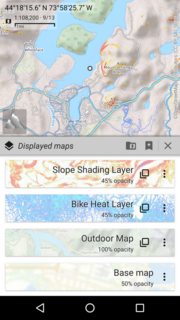
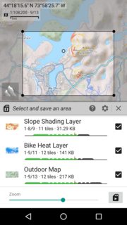
The OSM website is rudimentary by design. It doesn't even show all the details the OSM database actually contains (guideposts, fords, cols, and much more). For what you want, you can use something like Caltopo, or any of the better navigation apps, that can overlay maps. For example, using Alpinequest (Android app), I can create whatever "layer cake" I want and then download it for offline use. Here's TF Outdoors (derived from OSM) + Strava Bike Heat Map + Caltopo's Slope Shading


...I have been downloading trail tracks from OSM and converting them into GPX files for plotting on topos with my GPS software to make my own maps...
Check out Waymarked Hiking Trails (link above). You can select any trail (designated as a route), see its length and elevation profile, and download it as a GPX file. If the map-editor did his job right, that trail is based on several GPS tracks and more "true" than a single one. Less work for you!

Example: Boot Spur Trail
 
Last edited:
I find it kind of disturbing that most of these discussions about rescues are focused on carelessness and getting charged (or not). Really, what does it matter?.

Well, for me, I enjoy hiking off trail, solo, in all four seasons. NH F&G hasn't provided much clarity on whether or not that activity, in and of itself, is careless, reckless, or negligent.

I would like to think I bring enough judgment, knowledge, and gear with me that it would be difficult for them to charge me for a rescue. I have gotten the Hike Safe card each year since it was made available but I am still not sure exactly what having that cards means.
 
Last edited:
FWIW, I use OSM on my Garmin Edge 520 for cycling and they are always up-to-date.

My 76CSx has started freezing lately. Have to remove the batteries to restart it. Meanwhile, I used Guthook's NE Hiking App for a Tripyramids-Sleepers-Whiteface-Passaconaway loop and the track perfectly overlaid the trails that (used to be on?) GPS File Depot.

Tim
 
The trails in the Pemi on the East Side of Franconia Ridge (Franconia Brook/Lincoln Brook) are not maintained for "winter" travel, right? - it is not surprising people get lost in there if that's where he got lost.

No bridges/minimal maintenance..... these rescues cost FAR more that a bit more maintenance would.

I am not aware of any Trail being maintained for winter travel. Many trails are difficult to follow when the snow covers the tread. I am guessing you are referring to the rule to not having any blazing on the Lincoln Brook Trial. The Lincoln Brook Trail is a Zone B and is maintained as such. Those types of trails were where I tested my route finding skills before I started bushwhacking in ernest. I appreciated the existence of trails maintained to a lower standard.

BTW the AMC summer crew made a very aggressive brushing out of the LBT from Camp 13 through to the FBT a year or two before Hurricane Irene; the LBT isn't nearly as tough to follow as it once was.
 
Last edited:
Folks,

I am sure Guy Waterman would be spinning in his grave if he saw this thread.

My god, how did we hike / bushwhack ANYTHING in the 70s without all these digital doo-dahs???

Suggestion: Leave all that stuff (including your cell phone) home on your next hike or bushwhack and see what that feels like.

cb
 
I am not aware of any Trail being maintained for winter travel. Many trails are difficult to follow when the snow covers the thread. I am guessing you are referring to the rule to not having any blazing on the Lincoln Brook Trial. The Lincoln Brook Trail is a Zone B and is maintained as such. Those types of trails were where I tested my route finding skills before I started bushwhacking in ernest. I appreciated the existence of trails maintained to a lower standard.

As a WMNF trail adopter, we're told explicitly that trails are not maintained for winter use. The 4'x8' passageway for non-wilderness trails can easily become obscured due to deep snow and bend-overs. Some of those trails, by way of being hiked a lot in winter have become somewhat maintained for winter due to some higher brushing being done (be it organized or rouge). I'm taller, and with basic tools I can easily brush to 10', so I do - but I don't expect someone who is a foot shorter to do the same. I've never brought paint with me to paint new blazes as the trails I've maintained have had very obvious tread-ways, existing blazes, or signs (although I did have to report a sign missing for the Guinea Pond spur). I've mentioned it in other posts, but I have concerns that a lot of people enter the Wilderness without reasonable expectations of what to expect. Some wilderness trails are blazed (either actively or have remnants), and blazes seems to be a crutch for a lot of people (based on complaints around there being a lack of them). Not all wilderness trails are created equal, for sure, but I think a clearer sign when entering the wilderness might help - akin to the yellow 'STOP' signs before entering the Presidential Range. I think for most people, the current signs might as well just be mile markers.

Of course none of this might actually be relevant to this particular incident.
 
Well, for me, I enjoy hiking off trail, solo, in all four seasons. NH F&G hasn't provided much clarity on whether or not that activity, in and of itself, is careless, reckless, or negligent.

I would like to think I bring enough judgment, knowledge, and gear with me that it would be difficult for them to charge me for a rescue. I have gotten the Hike Safe card each year since it was made available but I am still not sure exactly what having that cards means.

You might find this quote from the Concord Monitor article interesting: http://www.concordmonitor.com/Found-hiker-in-good-condition-after-2-days-in-wilderness-9693880

"Jordan noted that many people in the hiking community do not share his opinion about the suitability of solo hiking, and that hiking alone has not been classified as a form of negligence that would lead the state to bill for a rescue."
 
Less work for you!
I have it worked out pretty well at this point so the amount of work is pretty small:
About 2 clicks to download a data file from the OSM website and then running a shell file (which takes less than a second to run the sequence of 3 programs to do the data selection and conversion to GPX format).

The maps that I have generated by plotting the above tracks on topo maps are the best hiking maps that I am aware of for some local conservation areas.

I also have a copy of the GPX files for the WMNF based upon GPS data from the USFS...
See:
http://www.vftt.org/forums/showthread.php?38643-WMNF-GIS-trails-data-GPX
http://www.vftt.org/forums/showthread.php?52139-GPS-tracks-for-NH-4K
and the track files can be found at:
http://trailsnh.com/GPS/WMNF-2008-trails-GPX-files.zip

Thanks for the links to the other sources--I'll check them out when I get a chance.

Doug
 
"Jordan noted that many people in the hiking community do not share his opinion about the suitability of solo hiking, and that hiking alone has not been classified as a form of negligence that would lead the state to bill for a rescue."[/QUOTE]

The Fish and Game are no different then any other company or organization, they look at things through their own rose colored lenses. If you took the amount of solo hikes accomplished each year and stood the amount of rescues for solo hikers against that number, the argument would never hold up in court. If they were to rescue me and fine me based solely on being solo, I would fight it in court, even if it cost me a small fortune.:eek:
 
I am not aware of any Trail being maintained for winter travel. Many trails are difficult to follow when the snow covers the thread. I am guessing you are referring to the rule to not having any blazing on the Lincoln Brook Trial. The Lincoln Brook Trail is a Zone B and is maintained as such. Those types of trails were where I tested my route finding skills before I started bushwhacking in ernest. I appreciated the existence of trails maintained to a lower standard.

BTW the AMC summer crew made a very aggressive brushing out of the LBT from Camp 13 through to the FBT a year or two before Hurricane Irene; the LBT isn't nearly as tough to follow as it once was.

Lions Head Winter Route may be the exception.
 
I am sure Guy Waterman would be spinning in his grave if he saw this thread.

My god, how did we hike / bushwhack ANYTHING in the 70s without all these digital doo-dahs???

Suggestion: Leave all that stuff (including your cell phone) home on your next hike or bushwhack and see what that feels like.

cb

Guy Waterman was a Luddite?

How does it feel to bushwhack without the "doo dahs"? It feels like when I use a map and compass. That's how it feels like.

Two false assumptions:
- All GPS users can't navigate without one.
- All M&C users are techno-illiterate.
 
... If you took the amount of solo hikes accomplished each year and stood the amount of rescues for solo hikers against that number, the argument would never hold up in court.
I'll bet the stats easily support your hypothesis.

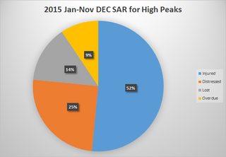
Two years ago, over on the ADKHP forum, people were complaining that "lost hikers" were an ever-growing plague, sucking the life out of state resources. I tallied up all the rescues from Jan-Nov 2015 and came up with this:


"Lost hikers" was in third place ... and represented 9 people out of the ~150,000 hikers who visit the High Peaks annually. Each and every rescue is unfortunate (and costly) but just a tiny fraction of the number of hikers who safely visit the backcountry.


Stats:
Injured Hiker: 33
Distressed Hiker: 16
Lost Hiker: 9
Overdue: 6
 
Last edited:
I'll bet the stats easily support your hypothesis.

Two years ago, over on the ADKHP forum, people were complaining that "lost hikers" were an ever-growing plague, sucking the life out of state resources. I tallied up all the rescues from Jan-Nov 2015 and came up with this:


"Lost hikers" was in third place ... and represented 9 people out of the ~150,000 hikers who visit the High Peaks annually. Each and every rescue is unfortunate (and costly) but just a tiny fraction of the number of hikers who safely visit the backcountry.


Stats:
Injured Hiker: 33
Distressed Hiker: 16
Lost Hiker: 9
Overdue: 6

So this week, we had two different groups of people that needed rescuing and one solo hiker. I think this small sample size proves that hiking in a group is riskier than solo hiking.

Right?

Solo hiking isn't riskier, its the smaller margin of error can be life-threatening. The risk is the same whether in a group, or alone.
 
So this week, we had two different groups of people that needed rescuing and one solo hiker. I think this small sample size proves that hiking in a group is riskier than solo hiking.

Right?

Your sample size is waaay too small to make any conclusions. The data I posted was based on nearly a year's worth of the DEC's SAR reports (the stats I posted were constrained to the High Peaks area). BTW, in case it was unclear, I was agreeing with Sierra's point. An examination of the stats would probably show that solo hikers don't represent the majority of all rescues. Most of the injuries I read about in 2015 were sustained by people hiking with one or more companions.
 
Last edited:
My post was kind of toungue-in-cheek. I wasn't serious.

The majority of people hike with others the majority of the time. Therefore, it stands to reason, that most injuries will happen to someone who is hiking with others. I agree with Sierra also. Its not solo hikers who need rescue more often, its hikers. The odds of any one hiker getting injured is exactly the same. The odds of any one hiker needing rescue is exactly the same.

Now, if one is talking about survival, the odds of surviving an injury favor those in a group. Most people hike in groups of two or more, most people survive injuries.
 
You might find this quote from the Concord Monitor article interesting: http://www.concordmonitor.com/Found-hiker-in-good-condition-after-2-days-in-wilderness-9693880
[...]

I don't have any medical background but from the reading of this article it seems to me like there was not much time left for the rescuers to find this guy. Kudos to all people involved in SAR effort for saving his life!

This is where VFTT, the pre-eminent online hiking community for the Whites, may want to collectively ask itself if "bushwhack routes" belong on public maps. I think they should not, but then I'm seeing the topic through the lens of an Adirondack preservationist (don't promote unofficial routes). I'm not steeped in the local customs of the Whites. Maybe the Brutus and Black Pond bushwhacks are so well-known, and so well-trodden, that they transcend the classic definition of a bushwhack and are effectively trails.

Speaking purely for myself i use this rule of thumb:
  • If a trail is blazed or not blazed but still "officially" exists I mark it on OSM even if it is poorly maintained
  • If I walk a herd path and it appears to be under active use, I will mark it but I won't create a trail relation for it
  • If a path is barely visible and not official trail I may upload my traces but I won't mark it.
The interesting part about Brutus bushwhack as marked on OSM is that the contributor tagged it with trail_visibility=bad. I read it as "maybe this should not really be showing up on the map."
Brutus.jpg

@iAmKrzys
Haha! Just found your moniker in OpenStreetMap! You're definitely no stranger to OSM! :)

Indeed, with over 1k edits, I am probably not a novice anymore! :)
Thanks for encouraging other hikers to contribute to OSM!
 
Top