NH topo map snippet quiz (part II)

vftt.org

Help Support vftt.org:

This site may earn a commission from merchant affiliate links, including eBay, Amazon, and others.

arghman

New member
Joined
Sep 1, 2004
Messages
1,352
Reaction score
153
Location
Goffstown, NH Avatar: No Once-lers or thneeds
Same deal as before.
(please wait until tomorrow morning before posting! :D )

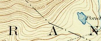
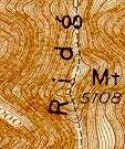
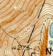
Identify the current name of each of the following reasonably-well-known natural features in New Hampshire. These are small cropped images from the Historic USGS Maps of New England collection. North is up in all cases (e.g. these are all crops, no rotation) Some should be easy and some are difficult. Bonus points if you give a reason for what part of the image either gives it away or makes it more confusing than it ought to be.

1.
362007607_ef0720a83f_o.jpg
2.
316767631_68cf9830f0_o.jpg
3.
362007599_23bf5ad933_o.jpg
4.
316763244_65a79e9647_o.jpg
5.
316763206_70eef0f23a_o.jpg

6.
316763184_18cc34db5f_o.jpg
7.
316763201_be3eb90ac6_o.jpg
8.
316763173_893bd74a6d_o.jpg
9.
316763231_c7fed9a815_o.jpg


(just some empty space to help you not see answers)
 
I have 7 of them i think....a few with the help of Mattl....

1. North Kinsman
2/ Old Man of the Mountain (The Profile)
3. ????absolutely clueless
4. Boundary Pond...Pittsburg, NH (was called Mountain Pond)
5. Mount Washington summit cone (this one stumped me for awhile!!)
6.Pond of Safety
7. Mt Moosilauke
8. Mt Lincoln
9. ????

grouseking
 
#1 - North Kinsman Mountain. The elevation, steep eastern slope and the Pond.

#2 - The side of Cannon Mount formerly known as Profile Mountain. The title "Th(e) Pr(ofile)" (may he rest in peace) is on the right side.


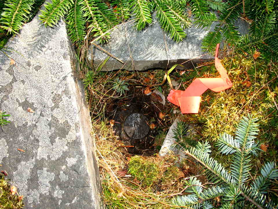
#4- That is now called Boundary Pond. Unmistakable to 3K baggers who will follow the faint trail into the boundary from East Inlet Road along the north of this pond an bag D'Urban to the right and Trumbull and Salmon to the left. Here's the pond viewed from the boundary:

October_8_1355.thumb.jpg


And that monument whose number you so cleverly cut off is #477:

October_8_1356.thumb.jpg


#5 Gotta be Mount Washington. How many mountains have both a railroad and a road to the summit.


#7 - Moosilauke. I recall there was a Tiptop House there a while ago (also there was one on Washington, but the shape is wrong.)


#8 - Mount Lincoln The elevation is a give away (although I know it has shrunk since that old map was made), plus the shape of the ridge plus the word "Ridg(e)".


That's enough ... let someone else make some guesses.
 
Last edited:
Papa Bear said:
#4- That is now called Boundary Pond. Unmistakable to 3K baggers will follow the faint trail into the boundary from East Inlet Road along the north of this pond an bag D'Urban to the right and Trumbull and Salmon to the left. Here's the pond viewed from the boundary:
The peak to the L was not on the first 3k list because from the 15' map the summit might have been in Canada. I climbed it anyway and got Gene to add it to the list as "Mountain Pond" although he said it should have "Roy Schweiker Peak" as I made the first ascent. Now it appears that some guy named Trumbull got there first :)
 
RoySwkr said:
The peak to the L was not on the first 3k list because from the 15' map the summit might have been in Canada. I climbed it anyway and got Gene to add it to the list as "Mountain Pond" although he said it should have "Roy Schweiker Peak" as I made the first ascent. Now it appears that some guy named Trumbull got there first :)
As I'm sure you know Roy, the 3K list calls it 3277 often it's often called "Snag Pond" after a nearby feature. I have taken to calling it Trumbull after the triangulation station (commonly called a "benchmark") set by the IBC (International Boundary Commision) in 1916 on the summit. Interestingly, the IBC identifies it as being in Quebec (Frontenac County, Chesham Township), but it looked to me like it was exactly on the line. If it's off the line, it's by a matter of feet. Here's the NGS page TRUMBULL IBC. Somewhere the IBC calls this Trumbull Mountain, but that isn't on the NGS page and I can't find it at the moment.

And here's trumbull:


(click for full size)
 
Last edited:
Papa Bear said:
As I'm sure you know Roy, the 3K list calls it 3277 often it's often called "Snag Pond" after a nearby feature. I have taken to calling it Trumbull after the triangulation station set by the IBC in 1916 on the summit. Interestingly, the IBC identifies it as being in Quebec (Frontenac County, Chesham Township), but it looked to me like it was exactly on the line. If it's off the line, it's by a matter of feet.

I've been up to the summit of Snag Pond twice and it's really flat, but more importantly the register is on the USA side of the swath! ;)
 
RoySwkr said:
So that's what the "ee" was - the end of "Ossipee"! I admit I looked at Mount Sunnapee, but it was no match. I did a quick look at Roy's Topozone link the other day and saw Mt Shaw and I said "well, whatever ". Then just now I said "hey, I climbed a Mount Shaw - that's the high point of that circular ring dyke. Where is that - Oh yeah, Ossipee Range". Then I said "Ossipee - hey that's the double "ee" in the snippet".

Better late than never. :) (there should be an emoticon with a light bulb turning on.)

Look at this map at a larger scale. It's an extremely interesting formation. Did you ever see anything like it? 10 miles across.
http://www.topozone.com/map.asp?lat=43.77239&lon=-71.27189&s=250&size=l&u=4&datum=nad27&layer=DRG
 
The collapse of a magma chamber often forms a caldera at the surface and a ring dyke at depth. The Ossipee Ring Complex, dated at 125 Ma and part of the White Mountain Igneous Province in New Hampshire, it contains volcanic rocks, landslide breccias and a 10 km-diameter ring dyke. We hypothesize that caldera collapse was responsible for the accumulation of volcanic rocks, formation of breccias and the ring dyke.

from:
http://adsabs.harvard.edu/abs/2004AGUSM.V43A..15K

It is an interesting geographical formation for sure.

Tim
 
To return to the trivia theme:
What do Mt Shaw of Ossipee Range and North Peak of Pawtuckaway Range have in common (too easy for PB)?
 
arghman said:
county highpoints? (Carroll & Rockingham)

I need to be a little trickier in the future, you guys got those too quickly. :p


Well, I'm a map nerd and love looking at them from every different angle, so no matter how hard you get, I'm gonna be lookin at every different one, probably for hours.

Yes, hours. :rolleyes:


grouseking
 
arghman said:
fine, be that way, then... here's one more to make 10 (forum has a 9-image limit), probably too easy to keep grouseking off the trail for long... ;)

QUOTE]


Didn't even have to look that one up ;) . All kidding aside, these are fun, and I hope you do them again soon. Actually maybe I'll make one up some time. How do you cut and paste these? I'm pretty inexperienced with things like photoshop or paint...or whatever its called.

grouseking
 
grouseking said:
... How do you cut and paste these? I'm pretty inexperienced with things like photoshop or paint...or whatever its called.

grouseking
What I do is

1) display the map (or other image or anything actually)
2) hit the save screen botton (left button above the "Insert" key on the keypad which is above the arrow keys.) What this does is puts the screen bitmap into the clip board.
3) Go to your photo program. Most any will do. I use Thumbs Plus. Photoshop or any of the others should work.
4) Paste the screen save into an image. In Thumbs Plus it's under "Edit" in the main menu - it's "Paste Screen Shot". Since it's just an image on the clip board, you could actually paste it into a word document if you felt like it.
5) Crop as desired
6) post the result into your message in the usual way.


This is basically how people get shots of menus, dialog boxes, etc. on the screen when they want to document how to do stuff.
 
Top