tripyramids

vftt.org

Help Support vftt.org:

This site may earn a commission from merchant affiliate links, including eBay, Amazon, and others.

hikes-with-him

New member
Joined
Feb 5, 2009
Messages
479
Reaction score
51
Location
Small Town in Maine
Three questions:

1. What is the best way to get both (or all three) peaks? North/South slide loop, Sabaday/Pine bend brook loop, something else?

2. North slide vs. Huntington Ravine's trail? How do they compare?

3. I've heard (trip report on another site from May 2009) that the trail on the top of the N. slide and the trail from N to Middle to South is very hard to follow...not maintained. Is it still like this?

Thanks.
 
Can only comment on North Slide.....

It's pretty crazy if you haven't done anything like it. The difficulty of the trail is somewhere between Flume Slide and Huntington Ravine in my opinion. I did it solo a few years ago and I won't do that again. I'm not really afraid of heights, but this was a bit crazy. If you were to fall on the ledges, it could be bad. However, I would do it again as part of a group.

Back in 2008, the trail between all the summits was extremely easy to follow. I don't see how that could have changed.
 
Depdending on how you are driving over from Maine, the choice of a approach from the Kanc vs Waterville valley could be a couple of hours of extra driving time. As I drive from the north country, I always do this trip from the Kanc, usually Pine Bend up to the ridge and then Sabathday down. I dont remember the trail being particulary hard to follow as it gets a lot of use and the trailbed is pretty well worn into the soil. The only issue for some folks is that Sabathday has multiple stream crossings that require fording. Unless the water is exceptionally low (late season drought conditions), there is a slim chance of rock hopping, so plan on wading on through. At the end of a long day of warm weather hiking, its not an issue ( I would recomend sandals or crocs) but can be an issue in cold rainy weather.

I have not hiked the slides, many folks complain about the long approach from the trailhead and others complain about loose rock cascading down from parties above them. The long approach is easy to manage, but the loose rocks falling is probably an issue on a busy day.

There was active loggin operations in the area i the last year whihc may have impacted the condition of the trails, it may be worth searching for the thread.
 
Do I remember you posting about Owl's Head? The South Slide is much like the OH Slide: sandy and loose. Personally, I like it and don't have a problem with it, unlike the solid slabs of the North Slide which set my acrophobia off. I've gone up and down the South Slide without incident (well, there was that rock I rolled into una_dogger, but let's not dredge that back up). It's a fine loop to go up the South Slide, over the Tris, then come down the Scar Trail which will descend steeply but with good footing back to the car.

The only time I ever had issue with the ridge trail was in early season when there was still a thin layer of snow on the ground. We couldn't see the treadway because it wasn't yet a monorail, but the blazing wasn't quite sufficient. In summer, however, the footway is very obvious and easy to follow.
 
In winter the trail between peaks is a bit harder to follow since it is Wilderness, not brushed as thoroughly, and you are walking in the trees.

In summer, I had no problem doing the loop clockwise - up North Slide and down South Slide. The approach is a bit monotonous (Livermore Road.)

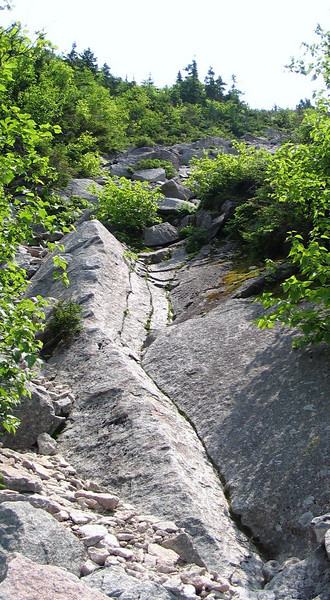
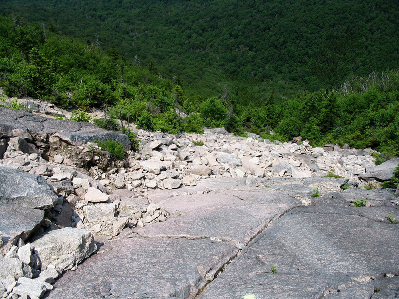
Looking down the North Slide:


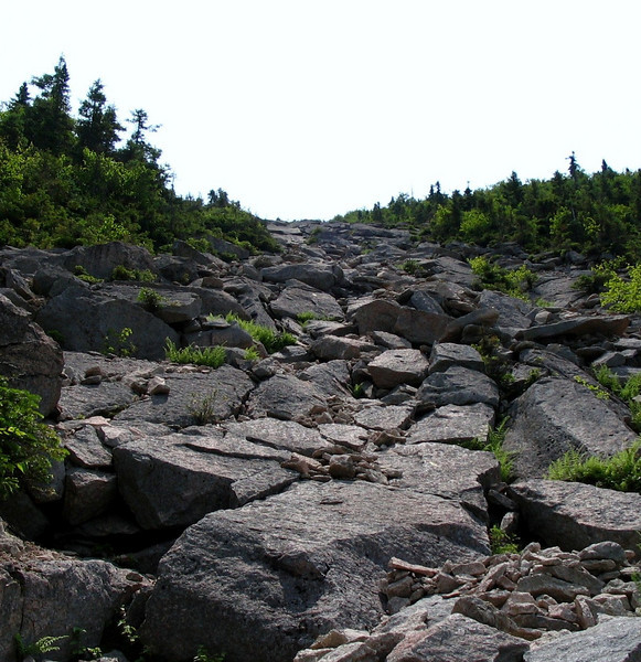
Looking up the South Slide:


I thought the Flume Slide was a bit more challenging than the North Tri Slide. I've only been down the Owl's Head slide and it was wet and icy :eek:

Tim
 
Also, have you seen this book? It's the absolute best reference on everything about the 4Ks. It has information about just about every possible route you could take to each of them:

4000-Footers of the White Mountains

Just bought it!!! This will be VERY helpful, I'm sure.

Can only comment on North Slide.....

It's pretty crazy if you haven't done anything like it. The difficulty of the trail is somewhere between Flume Slide and Huntington Ravine in my opinion.


Have done Huntington Ravine but not Flume slide...Huntington's was right at the line of what we feel we can do. The whole walking UP at a steep pitch with nothing keeping you on the slab but friction is a bit much sometimes. Are there any handholds...or is it "smearing" for quite a ways?
 
Have done Huntington Ravine but not Flume slide...Huntington's was right at the line of what we feel we can do. The whole walking UP at a steep pitch with nothing keeping you on the slab but friction is a bit much sometimes. Are there any handholds...or is it "smearing" for quite a ways?

I think if you're okay with Huntington, then North Slide will be fine. I didn't find it too daunting; the hardest scramble was right at the bottom. The rest was just enjoyable and challenging, but not scary. I don't remember having to do much smearing, which I am not fond of either. That being said, I wouldn't do it in bad weather.

The trail on the ridgeline, in summertime, is easy to follow - no concerns there.

I like the Pine Bend Brook/Sabbaday loop. The stream crossings were easy this past weekend, and I saw all of three people the whole day, on a holiday weekend (except for right at the Falls, five minutes from the car).
 
Have done Huntington Ravine but not Flume slide...Huntington's was right at the line of what we feel we can do. The whole walking UP at a steep pitch with nothing keeping you on the slab but friction is a bit much sometimes. Are there any handholds...or is it "smearing" for quite a ways?

Huntington's is harder, so it sounds like you will be fine. There are decent handholds along the entire thing, but I would avoid the slide the day after a heavy rain.
 
Have done Huntington Ravine but not Flume slide...Huntington's was right at the line of what we feel we can do. The whole walking UP at a steep pitch with nothing keeping you on the slab but friction is a bit much sometimes. Are there any handholds...or is it "smearing" for quite a ways?

If you've done Huntington's then you'll have no problem going up the North Slide. It is steep but is really about going up slabs of rock. I found plenty of handholds. There is also bushes/scrub on both sides of the slide to grab onto. Enjoy!
 
Living in Thornton I always hike the Tripyramids from the WV side. Personally, I like the North Slide. Challenging, yes, but not death defying. You also have the option from the WV of going up the Scaur Ridge Trail that bypasses the North Slide. I usually take this route in the winter if I am solo. Going up the South Slide, which is earlier than the North Slide, and then coming down the Scaur Ridge Trail is also an option. I cannot speak to hiking the Trips from the Kanc side since I’ve never done it from that direction.
 
Three questions:

1. What is the best way to get both (or all three) peaks? North/South slide loop, Sabaday/Pine bend brook loop, something else?

h-w-h,

When I was getting started with the 4000'ers (and before I knew of VFFT), I got all of my questions answered at Mohamed's website. When used with the AMC Guide, it has all the information a hiker needs. His "Routes To The Peaks" section has it all - comparative mileage, gain, and time, as well as subjective information too. I dont know of a better place on the web for info on summiting the 48.

Here's the link;
http://home.earthlink.net/~ellozy/index.html

GREAT reference...I've bookmarked it. Also...with this link, the book, and YOU ALL...I should be all set.

Thanks.
 
I've always gone up the N. slide (slabby low down, easier with loose rock higher up) and down the S. slide (easier than N, mostly gravel).

No problems on either one when dry.

Doug
 
I've done all three routes up to the Tripyramids. All were fine; but I wouldn't recommend the slide if conditions are wet. From Sabbaday there were a LOT of blowdowns in late March of this year. I don't know if they have been cleared. Also, as others have mentioned, if the river is high, you might have to get your feet wet, though the two lower crossings of Sabbaday Brook can be avoided with a short bushwhack. Pine Bend might be your best bet if there is or has been rain on or just before the day of you hike.
 
Last edited:
for further referance for anyone out there if you can do Hunningtons you can do anything in the whites.
 
Just did Pine Bend in and out last week - snow gone and water low

Last time I went up PB and down SB - farther out to road and then a mile along road

If you like slides, do N slide, if you don't then skip it - if you want to start from WV go up S slide then down Scaur Trail and if Livermore Rd is too boring use one of the connectors to Greeley Pd Tr for variety
 
Have done Huntington Ravine but not Flume slide...Huntington's was right at the line of what we feel we can do. The whole walking UP at a steep pitch with nothing keeping you on the slab but friction is a bit much sometimes. Are there any handholds...or is it "smearing" for quite a ways?

it's been a few years, but i remember the north slide being more of a friction climb on slabs where as huntingtons generally has good handholds. at the time it scared me just a little in parts. i've been meaning to revisit it. south slide is just tedious with lots of gravelly footing. if you want the most bang for the mileage go with the slide loop.
was on tripyramid the other day and the trail on the ridge was totally clear and easy to follow. only time i've ever had a problem is with deep snow cover.
have fun.

bryan
 
My hands down favorite way to enjoy the Tri's is up Dicey's (you can tag Passaconnaway) over to Rollins, Whiteface, across the Sleepers on the Kate Sleeper Trail, up the South Slide, over the Tripyramids and down Sabbaday. A full Sandwich Wilderness Traverse!!! Toughest part is the car spot. I think its 18 miles or so. For me there is no better way to do the Tri's, which are a boring, practically veiwless slog in and of themselves. :pSeems like a lot but Terra and I did this hike with a guy with a busted knee, a 72 year old woman, and an old dog in under nine hours. We were done by cocktail hour (which the 72 year old woman takes very seriously). Toughest part is the long carspot. I'd prolly add 1 hr for Passaconnaway.

Love the south slide. Much easier going than the OH slide, IMHO. More like a sandy foot bed with some scree here and there. Its pretty tame for a slide. Never done the North.
Happy Trails.
 
Last edited:
I've done north slide

I'm not a fan of the really steep stuff, but I was able to tackle the north slide, and make it up unscathed. FOr me, the hardest part was the first few minutes of the slide. There were a couple odd footings that I had to overcome. Plus, the bottom of the slide often has some damp/mossy spots, adding to the caution.

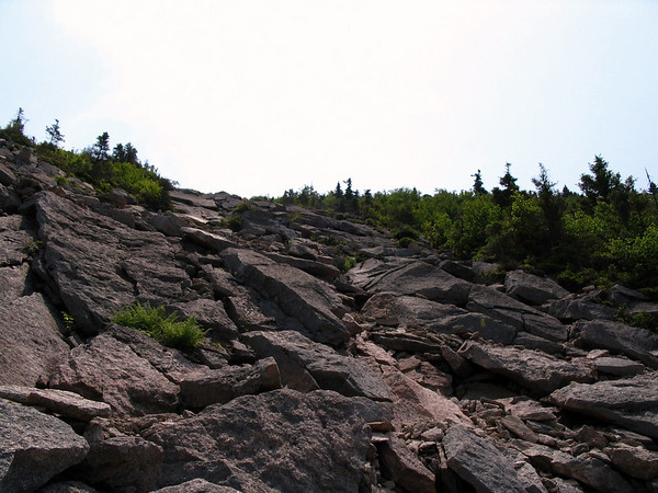
To give you an idea...and to add on to bikehikefish's pics

Near the bottom of the slide
786149029_h8ktR-L.jpg


786149064_zjcAh-L.jpg


786149183_7XzVc-L.jpg


786149355_oVDAV-M.jpg


so yeah, its a steep SOB! But fun nonetheless...and the views are spectacular, as long as you aren't dead tired. :)

Unadogger's trip sounds like a very fun traverse as well, since you avoid the steepness of the north slide, and hike through some beautiful varying terrain and different types of forests, and then end at some waterfalls. And yes, the south slide is nowhere near as ridiculous, plus you pop out partway up it anyways.

Here is one more thought....from David Metsky's web site.

http://hikethewhites.com/tri_p2/index.html

hope it all helps.

grouseking
 
Top