White Mountain National Forest Open as of Tuesday 8/30/2011

vftt.org

Help Support vftt.org:

This site may earn a commission from merchant affiliate links, including eBay, Amazon, and others.
Out of curiosity, since you just posted this on thread that said the WMNF is closed until further notice, why are hiking when you just read that you are not supposed to be?


Brian

Let me indulge your curiosity, I posted that I would be TRYING to hike Monroe tommorrow. Since I live in NH, have the day off, the weather is supposed to be nice, I will be heading to the whites. My Goal is to park at cog base station ascend monroe via the ammo trail maybe even climb Washington. Now keep in mind the is a goal that may not happen. It may not be safe, I will not put others in danger because I am to macho to give up on a hike. I may not be allowed to get near the trailhead. Lightning may strike me dead before then. I am not looking to go up there and become a pain in the but for those trying to clean up If I can get up there and Hike great if not at least I will be in the white mts instead of boring derry nh sitting on the couch watching hbo. If hiking is not possible tomorrow I will most likely drive around the whites taking photos to share with everyone that isnt so close.
 
Let me indulge your curiosity, I posted that I would be TRYING to hike Monroe tommorrow. Since I live in NH, have the day off, the weather is supposed to be nice, I will be heading to the whites. My Goal is to park at cog base station ascend monroe via the ammo trail maybe even climb Washington. Now keep in mind the is a goal that may not happen. It may not be safe, I will not put others in danger because I am to macho to give up on a hike. I may not be allowed to get near the trailhead. Lightning may strike me dead before then. I am not looking to go up there and become a pain in the but for those trying to clean up If I can get up there and Hike great if not at least I will be in the white mts instead of boring derry nh sitting on the couch watching hbo. If hiking is not possible tomorrow I will most likely drive around the whites taking photos to share with everyone that isnt so close.

I'm afraid I don't know your name (mine is Brian Glenn), but I would suggest to you, uh, Mr. Train, that you should not even drive up the road tomorrow, let alone attempt to hike up Mt. Monroe, because, until further notice, THE PARK IS CLOSED. That's what being "closed" means--it means you do not hike there.

Please do not hike on Mt. Monroe tomorrow, or anywhere else in the White Mountain National Forest until it re-opens, no matter how long that takes.


All the best,


Brian
 
Yup-- that's pretty much what he said!

If you do get up north, any info/visuals will be appreciated! Be safe :)

I will and I hope for your sake edmunds path is in good shape! My buddy who works at the willey house couldnt go to work today he lives in conway. He went hiking in fryeburg in a place called jockey cap and said there were rocks and washouts everywere. I think the trails in the whites will be worse:(
 
I though it was all in the state park - although they might be closed, too.

HERE is info on state parks. I walked up the S. Pack road yesterday evening even though it was posted as closed. Cleared any large branches and a few blocked culverts, no major damage.
 
I'm afraid I don't know your name (mine is Brian Glenn), but I would suggest to you, uh, Mr. Train, that you should not even drive up the road tomorrow, let alone attempt to hike up Mt. Monroe, because, until further notice, THE PARK IS CLOSED. That's what being "closed" means--it means you do not hike there.

Please do not hike on Mt. Monroe tomorrow, or anywhere else in the White Mountain National Forest until it re-opens, no matter how long that takes.


All the best,


Brian

My Name is Jim McMurchy and if there is anything else you would like to know just ask. I understand were you are coming from maybe they will open it tommorrow? I am not looking to be a rebel or a jerk If I end up sitting on the grass infront of the mt washington hotel with a good book, I will be happy. I am not gonna break any rules I am not the two hikers that needed SAR to pick then up on the autoroad, I am not gonna get in anyones way. I just want to see whats going on in or around our national forrest thats all
 
Moderator Note
This thread is for discussion of the conditions in the WMNF and official notices of status. Please keep discussions of individual hiking choices elsewhere.
End Moderator Note

And BTW, the WMNF is a Forest, not a Park.
 
A handful of pictures from my venture out on the roads today.

This is at the end of Little River Rd. which many people use as the winter route to North Twin. The Little River was running quite high I would say.
P1070509.JPG


The Ammo is still roaring as seen from Zealand Bridge.
P1070514.JPG


Recognize this bridge? You've probably driven by it even if you haven't walked across it.
P1070516.JPG


Recognize it yet? It's close to the Highland Center.
P1070518.JPG


It's the small bridge that used to be at the start (or end) of the Saco Lake trail.
P1070520.JPG


The bridge got carried downstream quite a ways.
P1070522.JPG


Rt. 302 is closed right at the start of the notch. The road has a major washout on this side of the Dry River Campground. They hope to have one lane open by tonight because there are people still trapped at the private campground (name ??) and the Notchland Inn located between the Dry River campground and the Fourth Iron bridge which was washed out.
P1070524.JPG


I took a ride up the Base Station Rd which is open all the way to the Cog and the Ammo is still running very high. This is recent debris from yesterday. Any river crossings on the Ammo trail would probably be very difficult if not impossible to cross, that's even if the WMNF trails were open at this time which they are not.
P1070533.JPG


I also talked to a couple of WMNF workers who had just checked out Jefferson Notch Rd. They said it was impassable due to washouts. Who knows when this road will be repaired.
 
And just saw that same notice on the White Mtn National Forest page.

Two dry days should get everything reasonably dried out, eh?

And a quick question (I did try searching this for a while): What are the latest feelings on mountain biking up to the Wilderness Trail. It's a two part question: Easy trail? (looks like it); ethically OK in terms of officially bagging the 48?

Looks like a nice stretch of weather, would hate to miss it.


Be aware that currently the Kanc is closed due to washouts in Lincoln and several in Albany so you may not be able to get to Lincoln Woods to try to hike it. If you do please be very very careful - even after 2 or 3 days the rivers are bound to be very high.
 
...and what is the intent of the closure? To ensure roads leading there and trails are reasonably safe. While many experienced VFTT hikers may be able to easily surmount large buildings or mountains in a single bound mere humans may hit trouble and FS would hather not have the distraction of dealing with the fallout.

Lowest common denominator much?
 
Franconia Notch State park re-opens

STATE PARKS - 2:26 p.m. - Hampton Beach and Franonia Notch re-open

The Division of Parks and Recreation have announced that Franconia Notch State Park and Hampton Beach State Park that they will re-open today. Hampton Beach State Park will open the main beach area but swimmers will only be able to go knee deep in the water. Franconia Notch State Park's Flume Gorge will be opening today at noon. State park officials are still assessing the other parks. For current information on the status of State Parks and Trails, visit nhstateparks.org.
---------------------------------------------
So we will have somewhere to hike!
 
A handful of pictures from my venture out on the roads today.

John . . . thanks for posting those terrific photos!

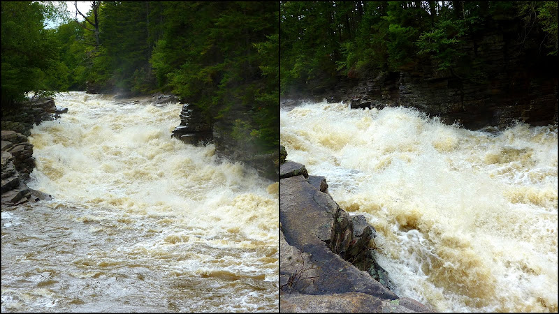
Hopefully, you won't mind me adding a snapshot to your collection??
Below is a composite shot of Lower Ammonoosuc Falls. It was taken at about 11 AM today (29-Aug).


Post_Irene.jpg
 
Last edited:
Cannon?
I though it was all in the state park - although they might be closed, too.
The summit is very close to the boundary and one trail is all in the state park

Many trails to non-4k are on private land and probably are not closed
 
At the moment you can't get there. From Conway, the Rte 302 bridge is out at the Sawyer River, by Fourth Iron tent site.

From the Twin end, today you could go to the top of the Notch but the DOT website claims you'll be able to get to the Willey Station Road, which is the Ethan Pond Trail trail head, but that's not quite far enough for the Davis Path.

AFAIK, there are people "trapped" in between these two points at the Crawford Notch Campground and they're working hard to get to them. Access from the west side will happen first, almost surely in just a day or two.
 
Looks like it will be open tomorrow, except where it is not:

http://www.fs.fed.us/r9/forests/white_mountain/conditions/

and

PDF list of things which are still closed.

(Jim: Ammo Ravine does not appear to be on the still-closed list so you may be able to attempt Monroe with permission of the WMNF after all. Ammonoosuc Lake Dam Road IS on the list, whatever/wherever that is.)

Don't take my word for it -- read all the official stuff. Despite the nice weather I will have to go to work. At least I plan to ride my bike...

Tim

Thanks for the heads up. I got a call last night from a friend who wants to hike local so I'm gonna go keep him company
 
Top