Two Rescued From Garfield

vftt.org

Help Support vftt.org:

This site may earn a commission from merchant affiliate links, including eBay, Amazon, and others.
It was then and is now never safe to blindly follow someone else's tracks. You have no idea if they knew where they were going or if they lead to your destination.
Doug

Definitely. I'm guessing a bunch of us have laid some tracks down and thought, "Boy, that was rough... I hope no one follows my tracks". We had one of those a couple seasons ago when we missing the sharp left turn going down the Skook and went into the beautiful open hardwood glade. Led to a nice 800' vertical climb back up and over the ridge to find the trial again. Oops!
 
Last edited:
I have no doubt about that, you would leave me in the dust. I was just saying the trail conditions have drastically changed. Considering your recent trip reports, I have no doubt you can " Hold your own" your having a heck of a season. Well done and good luck for the rest of the winter.
Sorry that I took your point the wrong way. Your post just hit a nerve that I'm probably just a bit sensitive about. Thanks for the praise though, I'm positive there's many hikers out there that are far faster than myself and others still with better endurance. For now its all just good training for the future. I'm sure you're no slouch yourself given your climbing experiences out west!

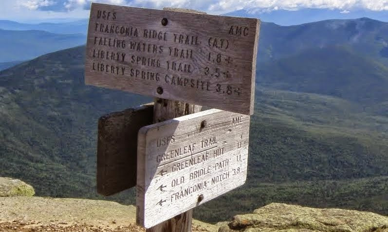
But getting back on track, I strongly feel that the location of the Greenleaf Trail/ Garfield Ridge Trail sign and junction are in a place that make it easy to miss if you're not familiar with the trail and are out in poor visibility. If you're coming up from South you could easily skirt the true summit slightly to the West by walking around some of the boulders and the Garfield Ridge Trail cairns, not the Greenleaf cairns, would lie in front of you but slightly to the right and you'd likely never see that you went perpendicularly across the Greenleaf Trail. If the intersection were moved 200 feet to the North away from all the summit boulders it might well make a difference and save someone's life. I agree with others that broken out conditions, trail condition postings, etc... all lead to more people being out where they shouldn't but this might be a simple and rather effective solution. Just my 2 cents though.

IMG_6154.jpg
The junction in question. Here I'm off trail East of the summit hiding out of the wind.
 
Last edited:
In case anyone is confused, the OBP doesn't go to the summit of Lafayette; it stops at the hut. The Greenleaf trail goes to the hut from there. This could also be confusing if people are looking for the sign to mention the Old Bridle Path if that's the only name they recognize.
 
The sign does give direction and distance to OBP

P8090069.JPG
 
In case anyone is confused, the OBP doesn't go to the summit of Lafayette; it stops at the hut. The Greenleaf trail goes to the hut from there. This could also be confusing if people are looking for the sign to mention the Old Bridle Path if that's the only name they recognize.

That is a great point. I wonder how many new to the mountain do not realize that. If I was climbing up the OBP for the first time, it would seem logical that it does go all the way to the summit. I can see this as an issue for some. Hmmm, the plot thickens.
 
I guess I am in the old school and possibly my interest in bushwhacking leads me to research a route in advance including studying and noting important points on a map including intermediate points. Signs to me are secondary to the terrain as they occasionally are buried with snow, obscured by rime ice or hanging on some sleezebags wall. If its a route I do frequently, I tend not to do as much research but for a first time hike especially in potentially questionable conditions, I make darn sure that I know where I am at and my backup options. Of course, I also have switched over to a "fair weather hiker" that is willing and able to turn around if the conditions are poor so my approach is different than someone who only goal is to tag a peak to check a box on a list. I think the best way to describe my current attitude is I have the skills, the gear but not the motivation. I have a heard a comment attributed to Waterman that there are young bold climbers but not a lot of old bold climbers. In the past I have crawled up to the summit sign of Lafayetee from Greenleaf due to the conditions but have always elected to go have a beer rather than proceeding. I have also done the same at Haystack.

I do admit one major fail on this concept many year ago on New Years day, Despite a lot of research we ascended the Tripyramid ridge from Sabathday Brook and proceeded to end up on the North peak instead of the south peak. We walked right by the trail to the south summit as the sign was missing. We were breaking trail so we didn't have the option of following a track. On the way down off of north we found the turn and got the correct peak just as a snow squall line moved in.
 
I think the phrase is, "There are old climbers, and there are bold climbers, but there aren't a lot of old, bold climbers." I've heard it attributed to different folks.
 
I guess I am in the old school and possibly my interest in bushwhacking leads me to research a route in advance including studying and noting important points on a map including intermediate points. Signs to me are secondary to the terrain as they occasionally are buried with snow, obscured by rime ice or hanging on some sleezebags wall. If its a route I do frequently, I tend not to do as much research but for a first time hike especially in potentially questionable conditions, I make darn sure that I know where I am at and my backup options. Of course, I also have switched over to a "fair weather hiker" that is willing and able to turn around if the conditions are poor so my approach is different than someone who only goal is to tag a peak to check a box on a list. I think the best way to describe my current attitude is I have the skills, the gear but not the motivation. I have a heard a comment attributed to Waterman that there are young bold climbers but not a lot of old bold climbers. In the past I have crawled up to the summit sign of Lafayetee from Greenleaf due to the conditions but have always elected to go have a beer rather than proceeding. I have also done the same at Haystack.

I do admit one major fail on this concept many year ago on New Years day, Despite a lot of research we ascended the Tripyramid ridge from Sabathday Brook and proceeded to end up on the North peak instead of the south peak. We walked right by the trail to the south summit as the sign was missing. We were breaking trail so we didn't have the option of following a track. On the way down off of north we found the turn and got the correct peak just as a snow squall line moved in.

Yes you are, as I suspect a lot of us on this site are. Sitting on the floor with the maps and guide out for hours, maybe in this social media days, its read a post like the sound of it, of we go!! If your truly prepared you have studied the guide and more importantly the maps. Before I went to live in CO for the 14ers, I had all the maps hanging on my wall, way in advance. Id spend hours with the guidebook studying the routes. If you as some do blindly set off just hoping to wing it, the Whites weather and terrain has some surprises for you.
 
The White's are very well signed comparatively speaking. And very well marked to boot.

Yes, but there is no sign here for the Garfield Ridge Tr (2 for Greenleaf and 1 for Franconia Ridge). I believe that is what causes the issues as Garfield Ridge looks most obvious as it continues along the ridge.
 
Yes you are, as I suspect a lot of us on this site are. Sitting on the floor with the maps and guide out for hours, maybe in this social media days, its read a post like the sound of it, of we go!! If your truly prepared you have studied the guide and more importantly the maps. Before I went to live in CO for the 14ers, I had all the maps hanging on my wall, way in advance. Id spend hours with the guidebook studying the routes. If you as some do blindly set off just hoping to wing it, the Whites weather and terrain has some surprises for you.

I do the same thing with my guide and maps. I love trying to read the topography and figure out which way to go, and what to expect. While I'm hiking I can generally picture where we are on the map.

One of the really interesting things I've noticed as a 'there are two types of people in the world' example is that, [literally] in my mind, the map is static and we move about within it; however, I know many people for whom the map spins, and they are always going 'forward'. Most car GPS screens now give you the option of spinning vs static map (click the icon of the compass to toggle this for some). I find it incredibly disorienting (but easy to follow) when the map spins, but I know other people get confused by static maps if they are driving south and they need to take a left (go east) because to them on the map, it's to the right. I suspect this same difference hits many a hiker - when north/south/east/west are the same as forward/backwards/left/right. At that point, getting lost seems like a foregone conclusion.
 
Yes, but there is no sign here for the Garfield Ridge Tr (2 for Greenleaf and 1 for Franconia Ridge). I believe that is what causes the issues as Garfield Ridge looks most obvious as it continues along the ridge.

The Horror!! (I'm being sarcastic not nasty). I just hope AMC doesn't decide to construct signage so our trails begin to look like a Manhattan block! Especially weary since they now auction those old signs off with a big old profit!
 
The sign does give direction and distance to OBP

P8090069.JPG

There used to be a sign for the Garfield Ridge Trail below these with distances to Galehead Hut among other things. I imagine that is an oversight or perhaps a damaged sign is being replaced? There certainly should be one that signifies the start of the trail near the summit of Lafayette.

I just googled pics of the summit of Lafayette and found it there as near as 2011 (edit - April 2013). Credit for the picture to VFTT member Chris Dailey's blog.

http://whitemountainimages.blogspot.com/2013/04/mount-lafayette-mount-lincoln-april.html
 
Last edited:
Hmmm, for some reason I was under the impression the FRT ran down to North Lafayette and GRT didn't start until there, but WMG says I'm mistaken. I agree that if this is the FRT and there's a trail and the only other sign is for Greenleaf, the confusion is a little more understandable.
 
You're mistaken but if you like the Skookumchuck trail, you'd think you would come out on the FRT but you don't. You come up to Lafayette on the GRT when you take the Skook.
 
Hmmm, for some reason I was under the impression the FRT ran down to North Lafayette and GRT didn't start until there, but WMG says I'm mistaken. I agree that if this is the FRT and there's a trail and the only other sign is for Greenleaf, the confusion is a little more understandable.

I was under that impression as well for some reason. I checked the trail descriptions in the AMC Guide 24th and 29th editions and the FRT ends/GRT begins on Lafayette summit. I even went back and looked at some of my old photos of Skoochumchuk/GRT junction and the signage agrees with AMC Guide. Not sure where I got that idea but is odd I'm not the only one. Maybe there is a sign somewhere that conflicts with Guide descriptions.
 
I was under that impression as well for some reason. I checked the trail descriptions in the AMC Guide 24th and 29th editions and the FRT ends/GRT begins on Lafayette summit. I even went back and looked at some of my old photos of Skoochumchuk/GRT junction and the signage agrees with AMC Guide. Not sure where I got that idea but is odd I'm not the only one. Maybe there is a sign somewhere that conflicts with Guide descriptions.

I do not think there is or has been a sign indicating this. I always have know the GRT starts there, its clear on any map. If you think about it, the layout of those trails makes sense, except for one, I think the OBP should continue to the summit and not the Greenleaf trail at the Hut. The OBP see way more traffic and the Greenleaf trail " Taking over" at the hut to the summit makes no sense to me. Then again, they never asked my opinion either.
 
I'd agree with Sierra, especially since historically they did use to get horses up to the top.

I'd wager that some of the confusions is due that what we consider the above the trees views on the ridgeline extend to the Skookumchuck beyond North Layfayette. The trail doesn't but the actual ridge does.

Same reason some people think Jackson is part of a Presi-Traverse. There was a President Jackson, but NH's 4,052 Ft. peak is not named for the President but for a historical cartographer.
 
I do not think there is or has been a sign indicating this. I always have know the GRT starts there, its clear on any map. If you think about it, the layout of those trails makes sense, except for one, I think the OBP should continue to the summit and not the Greenleaf trail at the Hut. The OBP see way more traffic and the Greenleaf trail " Taking over" at the hut to the summit makes no sense to me. Then again, they never asked my opinion either.

I've only done the Skook and that North Lafayette section three times, all within the last two years. I guess my memory is clouded. I just remember reading something and thinking it was weird that the FRT did not continue down to the Skook. Didn't make sense in my head, apparently because it was wrong! :)
 
Top